TopoQuest Logo
Do you find TopoQuest useful?
Help keep TopoQuest running and adding new maps/features by donating!
Bitcoin:  19c7KJd3qBynnjoSw5npx9KScwjBe4ifkT
Litecoin:  LXs6TkuXGGXo1vDsWCkWVdjQX94eUKd6ui
Home View Maps Find Maps Find Places Resources & Links


Fowler, Indiana Topographic Map

USGS Map Title: Fowler, IN
USGS Map MRC: 40087E3
DRG (GeoTIFF) Download: o40087e3.tif


Neighboring USGS Topographic Map Quads:


  Earl Park, IN  
40087F4
 

  Wadena, IN  
40087F3
 

  Mount Gilboa, IN  
40087F2
 

  Boswell, IN  
40087E4
 

  Fowler, IN  
40087E3
 

  Templeton, IN  
40087E2
 

  Tab, IN  
40087D4
 

  Pine Village, IN  
40087D3
 

  Chatterton, IN  
40087D2


Map MRC Location:

N41°
W88°
N41°
W87°
H8 H7 H6 H5 H4 H3 H2 H1
G8 G7 G6 G5 G4 G3 G2 G1
F8 F7 F6 F5 F4 F3 F2 F1
E8 E7 E6 E5 E4 E3 E2 E1
D8 D7 D6 D5 D4 D3 D2 D1
C8 C7 C6 C5 C4 C3 C2 C1
B8 B7 B6 B5 B4 B3 B2 B1
A8 A7 A6 A5 A4 A3 A2 A1
N40°
W88°
N40°
W87°

Fowler, IN USGS 1:24K Topographic Map Preview:
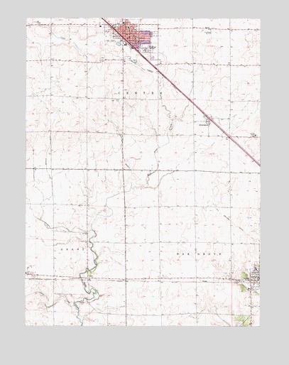
Fowler, IN USGS Topographic Map
Click on map above to begin viewing in our Map Viewer.

This topographic map contains these locations and features:
Feature Name Type Latitude Longitude GNIS ID View Map
BarcePopulated PlaceN40.6209°W87.2767°430485View Map
Benton CountyCivilN40.6063°W87.3109°450403View Map
Benton County Emergency Medical ServiceBuildingN40.6203°W87.3171°2719275View Map
Benton County Sheriff's OfficeBuildingN40.6171°W87.3161°2758457View Map
Boswell CemeteryCemeteryN40.5200°W87.3700°431373View Map
ChasePopulated PlaceN40.5195°W87.3420°432433View Map
FargoPopulated PlaceN40.5189°W87.2795°434388View Map
FowlerPopulated PlaceN40.6167°W87.3209°434729View Map
Fowler Center Township Volunteer Fire DepartmentBuildingN40.6183°W87.3231°2625983View Map
Fowler Police DepartmentBuildingN40.6179°W87.3204°2758153View Map
Fowler TheatreBuildingN40.6181°W87.3228°2712660View Map
Goose CreekStreamN40.5081°W87.3486°435191View Map
Humbert DitchCanalN40.6003°W87.3020°436601View Map
Old Academy ParkParkN40.5170°W87.2545°440528View Map
Oxford CemeteryCemeteryN40.5184°W87.2590°440818View Map
Perigo CemeteryCemeteryN40.5095°W87.3457°441020View Map
Sacred Heart SchoolSchoolN40.6236°W87.3209°446553View Map
Seamons DitchCanalN40.5570°W87.3609°443182View Map
SwaningtonPopulated PlaceN40.5834°W87.2772°444465View Map
Town of FowlerCivilN40.6172°W87.3186°2396945View Map
Township of CenterCivilN40.6064°W87.2947°453172View Map
Township of Oak GroveCivilN40.5194°W87.2652°453681View Map
Wattles DitchCanalN40.5736°W87.3239°445557View Map

Note: Coordinates in the location and feature list above are referenced to NAD83 datum.


Copyright (C) 2008-2025 Ryan Niemi / Sunset Dynamics ... All Rights Reserved