TopoQuest Logo
Do you find TopoQuest useful?
Help keep TopoQuest running and adding new maps/features by donating!
Bitcoin:  19c7KJd3qBynnjoSw5npx9KScwjBe4ifkT
Litecoin:  LXs6TkuXGGXo1vDsWCkWVdjQX94eUKd6ui
Home View Maps Find Maps Find Places Resources & Links


Boswell, Indiana Topographic Map

USGS Map Title: Boswell, IN
USGS Map MRC: 40087E4
DRG (GeoTIFF) Download: o40087e4.tif


Neighboring USGS Topographic Map Quads:


  Darrow, IL  
40087F5
 

  Earl Park, IN  
40087F4
 

  Wadena, IN  
40087F3
 

  Stockland, IL  
40087E5
 

  Boswell, IN  
40087E4
 

  Fowler, IN  
40087E3
 

  Ambia, IN  
40087D5
 

  Tab, IN  
40087D4
 

  Pine Village, IN  
40087D3


Map MRC Location:

N41°
W88°
N41°
W87°
H8 H7 H6 H5 H4 H3 H2 H1
G8 G7 G6 G5 G4 G3 G2 G1
F8 F7 F6 F5 F4 F3 F2 F1
E8 E7 E6 E5 E4 E3 E2 E1
D8 D7 D6 D5 D4 D3 D2 D1
C8 C7 C6 C5 C4 C3 C2 C1
B8 B7 B6 B5 B4 B3 B2 B1
A8 A7 A6 A5 A4 A3 A2 A1
N40°
W88°
N40°
W87°

Boswell, IN USGS 1:24K Topographic Map Preview:
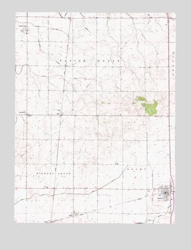
Boswell, IN USGS Topographic Map
Click on map above to begin viewing in our Map Viewer.

This topographic map contains these locations and features:
Feature Name Type Latitude Longitude GNIS ID View Map
Benton County Emergency Medical Service - Boswell StationBuildingN40.5144°W87.3788°2719327View Map
BoswellPopulated PlaceN40.5211°W87.3784°431372View Map
Boswell Elementary SchoolSchoolN40.5167°W87.3867°446564View Map
Boswell Grant Township Fire DepartmentBuildingN40.5197°W87.3851°2626037View Map
Clifton Airport (historical)AirportN40.5209°W87.4104°2677086View Map
DunnPopulated PlaceN40.5639°W87.4639°433791View Map
DunningtonPopulated PlaceN40.5642°W87.4909°433799View Map
Finigan DitchCanalN40.5870°W87.4742°434485View Map
FreePopulated PlaceN40.6217°W87.4572°434798View Map
Freeland ParkPopulated PlaceN40.6145°W87.4911°434812View Map
Gillen DitchCanalN40.5228°W87.3925°435076View Map
HandyPopulated PlaceN40.5009°W87.4714°435669View Map
Leuck DitchCanalN40.5173°W87.4650°437797View Map
Minier LateralCanalN40.6000°W87.4742°439267View Map
Saint Marys SchoolSchoolN40.5639°W87.4900°442717View Map
Salmon DitchCanalN40.6192°W87.4967°442939View Map
TalbotPopulated PlaceN40.5053°W87.4542°444550View Map
Town of BoswellCivilN40.5187°W87.3823°2396598View Map
Township of GrantCivilN40.5201°W87.3785°453334View Map
Township of Hickory GroveCivilN40.5204°W87.4808°453410View Map
Township of Parish GroveCivilN40.6069°W87.4532°453706View Map
Zion ChurchChurchN40.5350°W87.4192°446463View Map

Note: Coordinates in the location and feature list above are referenced to NAD83 datum.


Copyright (C) 2008-2025 Ryan Niemi / Sunset Dynamics ... All Rights Reserved