TopoQuest Logo
Do you find TopoQuest useful?
Help keep TopoQuest running and adding new maps/features by donating!
Bitcoin:  19c7KJd3qBynnjoSw5npx9KScwjBe4ifkT
Litecoin:  LXs6TkuXGGXo1vDsWCkWVdjQX94eUKd6ui
Home View Maps Find Maps Find Places Resources & Links


Ashburn, Missouri Topographic Map

USGS Map Title: Ashburn, MO
USGS Map MRC: 39091E2
DRG (GeoTIFF) Download: o39091e2.tif


Neighboring USGS Topographic Map Quads:


  Hannibal East, MO  
39091F3
 

  Hull, IL  
39091F2
 

  Barry, IL  
39091F1
 

  Hannibal SE, MO  
39091E3
 

  Ashburn, MO  
39091E2
 

  Rockport, IL  
39091E1
 

  Frankford, MO  
39091D3
 

  Vera, MO  
39091D2
 

  Louisiana, MO  
39091D1


Map MRC Location:

N40°
W92°
N40°
W91°
H8 H7 H6 H5 H4 H3 H2 H1
G8 G7 G6 G5 G4 G3 G2 G1
F8 F7 F6 F5 F4 F3 F2 F1
E8 E7 E6 E5 E4 E3 E2 E1
D8 D7 D6 D5 D4 D3 D2 D1
C8 C7 C6 C5 C4 C3 C2 C1
B8 B7 B6 B5 B4 B3 B2 B1
A8 A7 A6 A5 A4 A3 A2 A1
N39°
W92°
N39°
W91°

Ashburn, MO USGS 1:24K Topographic Map Preview:
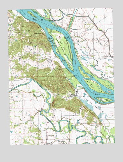
Ashburn, MO USGS Topographic Map
Click on map above to begin viewing in our Map Viewer.

This topographic map contains these locations and features:
Feature Name Type Latitude Longitude GNIS ID View Map
AshburnPopulated PlaceN39.5448°W91.1688°713425View Map
Ashburn BridgeBridgeN39.5056°W91.1701°754989View Map
Ashburn CemeteryCemeteryN39.5453°W91.1782°713426View Map
Ashburn Rural Volunteer Fire DepartmentBuildingN39.5450°W91.1729°2621661View Map
Battle CreekStreamN39.5817°W91.1924°713737View Map
Big CutoffStreamN39.6217°W91.1999°404398View Map
Blackbird IslandIslandN39.5400°W91.1365°714317View Map
Blackjack School (historical)SchoolN39.5659°W91.1260°1747219View Map
BuschPopulated PlaceN39.5798°W91.1926°740714View Map
Busch CemeteryCemeteryN39.5773°W91.2001°715104View Map
Centenary CemeteryCemeteryN39.6056°W91.2465°715624View Map
Centenary School (historical)SchoolN39.6123°W91.2440°743917View Map
Cincinnati LandingLocaleN39.5984°W91.1749°422553View Map
Cincinnati School (historical)SchoolN39.5998°W91.1754°1747228View Map
Clear LakeSwampN39.5773°W91.1285°406225View Map
Collins Pond SloughLakeN39.5683°W91.1465°406381View Map
Cronican SloughGutN39.5106°W91.1829°716507View Map
Denmark IslandIslandN39.5550°W91.1529°407124View Map
Drift IslandIslandN39.5534°W91.1321°407394View Map
Dupont Reservation Conservation AreaParkN39.5589°W91.1783°2093244View Map
Eagle IslandIslandN39.5470°W91.1374°407569View Map
Early BranchStreamN39.5023°W91.1863°717242View Map
Early CemeteryCemeteryN39.5481°W91.1787°717244View Map
Fools CreekStreamN39.6231°W91.2379°718054View Map
Gilbert ChuteStreamN39.5648°W91.1724°718438View Map
Gilbert IslandIslandN39.5900°W91.1832°729497View Map
Goose Gap HollowValleyN39.5273°W91.1668°718592View Map
Goose Pond (historical)LakeN39.6200°W91.1482°1747238View Map
Halfmoon SloughGutN39.5781°W91.1382°409646View Map
Happy HollowValleyN39.5453°W91.1974°719068View Map
Haw CreekStreamN39.5305°W91.2145°719222View Map
Haw Creek School (historical)SchoolN39.5200°W91.2347°744260View Map
Haw Creek SloughStreamN39.5137°W91.1960°719223View Map
Hog SloughLakeN39.5825°W91.1585°410355View Map
HopePopulated PlaceN39.5956°W91.2021°740939View Map
Horn BranchStreamN39.5000°W91.2021°719831View Map
Horseshoe LakeLakeN39.5254°W91.1989°719873View Map
Jakes HollowValleyN39.5231°W91.1618°720237View Map
Jim HollowValleyN39.6053°W91.2104°720323View Map
Jim Young IslandIslandN39.6200°W91.2201°411115View Map
Jolly CemeteryCemeteryN39.5898°W91.1993°720394View Map
LaMottePopulated PlaceN39.5606°W91.1796°740997View Map
Love School (historical)SchoolN39.5186°W91.1660°744269View Map
Mundy LandingPopulated PlaceN39.5517°W91.1610°741086View Map
Old Sugar CreekGutN39.5081°W91.1948°723792View Map
Omeys SloughGutN39.5934°W91.1407°415117View Map
Pfeiffer School (historical)SchoolN39.5956°W91.1488°1747254View Map
Pickerton HillSummitN39.5364°W91.1979°724307View Map
Riverland (historical)LocaleN39.5042°W91.1360°744284View Map
Robison CemeteryCemeteryN39.5761°W91.2304°725425View Map
Running SloughGutN39.5920°W91.1551°417041View Map
Schindler CemeteryCemeteryN39.5856°W91.2279°726100View Map
Shaleton (historical)LocaleN39.6192°W91.2326°740285View Map
Stevenson PondLakeN39.5785°W91.1607°419117View Map
Swain SloughStreamN39.6220°W91.1846°419444View Map
Taylor ChapelChurchN39.5192°W91.1704°729667View Map
Taylor IslandIslandN39.6153°W91.2121°419563View Map
Ted Shanks Conservation AreaParkN39.5306°W91.1358°713115View Map
Town of AshburnCivilN39.5458°W91.1720°2397440View Map
Township of Salt RiverCivilN39.5393°W91.1667°767194View Map
Vernon School (historical)SchoolN39.5773°W91.2002°2650333View Map
Walker AirportAirportN39.5223°W91.1707°2679357View Map

Note: Coordinates in the location and feature list above are referenced to NAD83 datum.


Copyright (C) 2008-2024 Ryan Niemi / Sunset Dynamics ... All Rights Reserved