TopoQuest Logo
Do you find TopoQuest useful?
Help keep TopoQuest running and adding new maps/features by donating!
Bitcoin:  19c7KJd3qBynnjoSw5npx9KScwjBe4ifkT
Litecoin:  LXs6TkuXGGXo1vDsWCkWVdjQX94eUKd6ui
Home View Maps Find Maps Find Places Resources & Links


Hannibal East, Missouri Topographic Map

USGS Map Title: Hannibal East, MO
USGS Map MRC: 39091F3
DRG (GeoTIFF) Download: o39091f3.tif


Neighboring USGS Topographic Map Quads:


  Quincy SW, MO  
39091G4
 

  Marblehead, IL  
39091G3
 

  Payson, IL  
39091G2
 

  Hannibal West, MO  
39091F4
 

  Hannibal East, MO  
39091F3
 

  Hull, IL  
39091F2
 

  New London, MO  
39091E4
 

  Hannibal SE, MO  
39091E3
 

  Ashburn, MO  
39091E2


Map MRC Location:

N40°
W92°
N40°
W91°
H8 H7 H6 H5 H4 H3 H2 H1
G8 G7 G6 G5 G4 G3 G2 G1
F8 F7 F6 F5 F4 F3 F2 F1
E8 E7 E6 E5 E4 E3 E2 E1
D8 D7 D6 D5 D4 D3 D2 D1
C8 C7 C6 C5 C4 C3 C2 C1
B8 B7 B6 B5 B4 B3 B2 B1
A8 A7 A6 A5 A4 A3 A2 A1
N39°
W92°
N39°
W91°

Hannibal East, MO USGS 1:24K Topographic Map Preview:
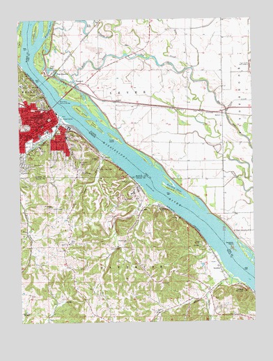
Hannibal East, MO USGS Topographic Map
Click on map above to begin viewing in our Map Viewer.

This topographic map contains these locations and features:
Feature Name Type Latitude Longitude GNIS ID View Map
AladdinPopulated PlaceN39.7164°W91.3232°422394View Map
Antioch Chapel Baptist ChurchChurchN39.6573°W91.3490°729273View Map
Bear CreekStreamN39.7101°W91.3518°713806View Map
Bird SloughStreamN39.7356°W91.3463°404460View Map
Bird Slough School (historical)SchoolN39.7295°W91.3310°741471View Map
Bird Slough School (historical)SchoolN39.7298°W91.3313°1725363View Map
Brinkmeier CemeteryCemeteryN39.6720°W91.3585°714712View Map
Broadway WharfLocaleN39.7120°W91.3549°741472View Map
Camp Oko-TipiLocaleN39.6575°W91.2790°715280View Map
Cardiff HillSummitN39.7167°W91.3629°715391View Map
Cave CityPopulated PlaceN39.6895°W91.3318°732996View Map
Cave HollowValleyN39.6946°W91.3308°735551View Map
Centennial Memorial LighthouseLocaleN39.7145°W91.3590°733000View Map
Central ParkParkN39.7092°W91.3588°732997View Map
Central SchoolSchoolN39.7075°W91.3646°715689View Map
Chenale Ecarte Club (historical)LocaleN39.7342°W91.3101°1725369View Map
Clear LakeLakeN39.7296°W91.3583°406219View Map
Clemens (historical)LocaleN39.6364°W91.2513°744066View Map
Clemens FieldParkN39.7050°W91.3596°741473View Map
Eagle SloughStreamN39.7298°W91.2843°407579View Map
Eagle Slough School (historical)SchoolN39.7453°W91.2940°1725378View Map
East HannibalPopulated PlaceN39.7298°W91.3510°422650View Map
Fall CreekStreamN39.6950°W91.3299°732998View Map
Fall CreekStreamN39.7495°W91.3193°408249View Map
Fall Creek GorgeValleyN39.6931°W91.3343°759869View Map
Field SchoolSchoolN39.7017°W91.3713°717901View Map
Fourmile ChuteChannelN39.6823°W91.2960°408592View Map
Fourmile IslandIslandN39.6784°W91.2926°408597View Map
Gilbert LandingLocaleN39.6442°W91.2626°736163View Map
HannibalPopulated PlaceN39.7084°W91.3585°735640View Map
Hannibal Fire Department Station 1BuildingN39.7075°W91.3575°2620986View Map
Hannibal Police DepartmentBuildingN39.7067°W91.3621°2752236View Map
Hannibal Post OfficePost OfficeN39.7063°W91.3628°2782918View Map
Hascall CemeteryCemeteryN39.6292°W91.3024°719196View Map
Hascall CreekStreamN39.6250°W91.3060°719197View Map
Holliday HillSummitN39.7114°W91.3701°754982View Map
Hope CemeteryCemeteryN39.6814°W91.3707°719788View Map
IlascoPopulated PlaceN39.6714°W91.3107°740953View Map
Inspiration PointLocaleN39.7217°W91.3696°732999View Map
Lily PondLakeN39.7496°W91.3404°412093View Map
Lookout MountainSummitN39.6373°W91.2557°721564View Map
Malaruni CreekStreamN39.6353°W91.2760°721772View Map
Marble CreekStreamN39.6750°W91.3029°721854View Map
Marble Creek CemeteryCemeteryN39.6584°W91.3182°721856View Map
Marble Creek School (historical)SchoolN39.6612°W91.3185°741474View Map
Marion County Sheriff's OfficeBuildingN39.7066°W91.3643°2752200View Map
Mark Twain Boyhood HomeBuildingN39.7119°W91.3575°732315View Map
Mark Twain Memorial BridgeBridgeN39.7207°W91.3568°425165View Map
Mark Twain RegionAreaN39.7000°W91.3335°760188View Map
McDonald ChuteStreamN39.7428°W91.3610°413248View Map
Mills Creek School (historical)SchoolN39.6670°W91.3718°741458View Map
Monkey RunPopulated PlaceN39.6723°W91.3013°722530View Map
Mount Olivet CemeteryCemeteryN39.6895°W91.3424°722832View Map
Mount Olivet Memorial ParkCemeteryN39.6859°W91.3435°722838View Map
Nippers ParkParkN39.7100°W91.3531°732331View Map
Old Smith School (historical)SchoolN39.6556°W91.2510°1725424View Map
Pearl IslandIslandN39.7067°W91.3349°424548View Map
Pettibone SchoolSchoolN39.7109°W91.3629°724265View Map
Pigeon CreekStreamN39.7117°W91.2640°415654View Map
Pool 22ReservoirN39.6424°W91.2538°760688View Map
River PointCapeN39.7100°W91.3531°732360View Map
RiversideLocaleN39.7019°W91.3478°732361View Map
Riverside CemeteryCemeteryN39.7013°W91.3425°725349View Map
Riverview ParkParkN39.7231°W91.3696°725361View Map
Robinson CemeteryCemeteryN39.6903°W91.3685°725416View Map
Rouse School (historical)SchoolN39.7064°W91.3043°1725441View Map
Running SloughStreamN39.7473°W91.2568°417043View Map
Running Slough School (historical)SchoolN39.6987°W91.2657°1725442View Map
Saint John SchoolSchoolN39.7025°W91.3699°725765View Map
SavertonPopulated PlaceN39.6464°W91.2682°726071View Map
Saverton IslandIslandN39.6548°W91.2610°418042View Map
ShepherdPopulated PlaceN39.7250°W91.3446°423182View Map
Shuck IslandIslandN39.7125°W91.3413°418479View Map
SpencerPopulated PlaceN39.7109°W91.2660°423197View Map
Tower IslandIslandN39.7012°W91.3238°419795View Map
Towhead IslandIslandN39.7492°W91.3596°737938View Map
Township of LeveeCivilN39.7219°W91.3086°429249View Map
Township of MasonCivilN39.6987°W91.3727°767001View Map
Treats DamDamN39.6484°W91.2768°761006View Map
Turtle IslandIslandN39.7450°W91.3654°419962View Map
Wabash BridgeBridgeN39.7242°W91.3621°741470View Map
Wild Cat CornerLocaleN39.7114°W91.3567°732424View Map
Ziegler IslandIslandN39.7423°W91.3746°729228View Map

Note: Coordinates in the location and feature list above are referenced to NAD83 datum.


Copyright (C) 2008-2024 Ryan Niemi / Sunset Dynamics ... All Rights Reserved