TopoQuest Logo
Do you find TopoQuest useful?
Help keep TopoQuest running and adding new maps/features by donating!
Bitcoin:  19c7KJd3qBynnjoSw5npx9KScwjBe4ifkT
Litecoin:  LXs6TkuXGGXo1vDsWCkWVdjQX94eUKd6ui
Home View Maps Find Maps Find Places Resources & Links


Blue Mountain Dam, Arkansas Topographic Map

USGS Map Title: Blue Mountain Dam, AR
USGS Map MRC: 35093A6
DRG (GeoTIFF) Download: o35093a6.tif


Neighboring USGS Topographic Map Quads:


  Magazine, AR  
35093B7
 

  Blue Mountain, AR  
35093B6
 

  Magazine Mountain NE, AR  
35093B5
 

  Sugar Grove, AR  
35093A7
 

  Blue Mountain Dam, AR  
35093A6
 

  Havana, AR  
35093A5
 

  Freedom Mountain, AR  
34093H7
 

  Gravelly, AR  
34093H6
 

  Bluffton, AR  
34093H5


Map MRC Location:

N36°
W94°
N36°
W93°
H8 H7 H6 H5 H4 H3 H2 H1
G8 G7 G6 G5 G4 G3 G2 G1
F8 F7 F6 F5 F4 F3 F2 F1
E8 E7 E6 E5 E4 E3 E2 E1
D8 D7 D6 D5 D4 D3 D2 D1
C8 C7 C6 C5 C4 C3 C2 C1
B8 B7 B6 B5 B4 B3 B2 B1
A8 A7 A6 A5 A4 A3 A2 A1
N35°
W94°
N35°
W93°

Blue Mountain Dam, AR USGS 1:24K Topographic Map Preview:
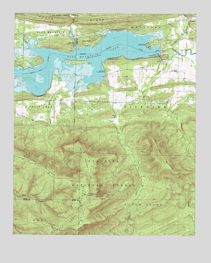
Blue Mountain Dam, AR USGS Topographic Map
Click on map above to begin viewing in our Map Viewer.

This topographic map contains these locations and features:
Feature Name Type Latitude Longitude GNIS ID View Map
Alexander A Scott CemeteryCemeteryN35.1112°W93.6302°73499View Map
Ashley CreekStreamN35.1045°W93.7074°70471View Map
Ashley Creek Recreation AreaLocaleN35.1079°W93.7091°76205View Map
Bakers CreekStreamN35.0779°W93.6252°70493View Map
Blue Mountain DamDamN35.1043°W93.6496°74689View Map
Blue Mountain LakeReservoirN35.0996°W93.7004°74690View Map
Cedar CreekStreamN35.1029°W93.6380°71063View Map
Cedar Creek Church (historical)ChurchN35.0931°W93.6716°67866View Map
County Line CemeteryCemeteryN35.0756°W93.7263°71240View Map
Crow CreekStreamN35.1070°W93.7399°70394View Map
Dry Creek MountainRidgeN35.0412°W93.7380°71446View Map
Dry Creek WildernessReserveN35.0273°W93.7435°74467View Map
Flood MountainSummitN35.0429°W93.6996°71641View Map
Havana Fire Department Morris Chapel StationBuildingN35.0932°W93.6454°2116547View Map
Ladds CreekStreamN35.0840°W93.7069°72276View Map
Lick CreekStreamN35.0879°W93.7005°72333View Map
Lick Creek Recreation AreaLocaleN35.0931°W93.6880°72338View Map
Moores Chapel CemeteryCemeteryN35.0931°W93.6413°67912View Map
Moores Chapel United Methodist ChurchChurchN35.0929°W93.6413°77685View Map
Moores School (historical)SchoolN35.0848°W93.6335°67913View Map
Outlet Recreation AreaParkN35.1006°W93.6527°72963View Map
Petit Jean MountainRidgeN35.0229°W93.6999°67083View Map
Petit Jean MountainSummitN35.0229°W93.6999°73054View Map
Potato Hill MountainSummitN35.0468°W93.6499°73174View Map
Potts RidgeRidgeN35.1209°W93.7138°73180View Map
Quarry HeightsPopulated PlaceN35.1101°W93.6966°73221View Map
Rock CreekStreamN35.1051°W93.6410°73338View Map
Rock Creek CemeteryCemeteryN35.1145°W93.6324°73344View Map
Small Smith CemeteryCemeteryN35.0934°W93.6421°2033672View Map
Smiths School (historical)SchoolN35.0848°W93.6852°67952View Map
Southern Home (historical)Populated PlaceN35.0909°W93.6858°67954View Map
Stonehouse Recreation AreaParkN35.0234°W93.6985°73727View Map
Township of RichlandCivilN35.0718°W93.6268°69888View Map
Township of WavelandCivilN35.1234°W93.6490°69893View Map
WavelandPopulated PlaceN35.1237°W93.6282°74027View Map
Waveland Park Recreation AreaLocaleN35.1076°W93.6582°78709View Map
Waveland Post OfficePost OfficeN35.1231°W93.6274°84408View Map

Note: Coordinates in the location and feature list above are referenced to NAD83 datum.


Copyright (C) 2008-2025 Ryan Niemi / Sunset Dynamics ... All Rights Reserved