TopoQuest Logo
Do you find TopoQuest useful?
Help keep TopoQuest running and adding new maps/features by donating!
Bitcoin:  19c7KJd3qBynnjoSw5npx9KScwjBe4ifkT
Litecoin:  LXs6TkuXGGXo1vDsWCkWVdjQX94eUKd6ui
Home View Maps Find Maps Find Places Resources & Links


Gravelly, Arkansas Topographic Map

USGS Map Title: Gravelly, AR
USGS Map MRC: 34093H6
DRG (GeoTIFF) Download: o34093h6.tif


Neighboring USGS Topographic Map Quads:


  Sugar Grove, AR  
35093A7
 

  Blue Mountain Dam, AR  
35093A6
 

  Havana, AR  
35093A5
 

  Freedom Mountain, AR  
34093H7
 

  Gravelly, AR  
34093H6
 

  Bluffton, AR  
34093H5
 

  Harvey, AR  
34093G7
 

  Little Texas, AR  
34093G6
 

  Chula Mountain, AR  
34093G5


Map MRC Location:

N35°
W94°
N35°
W93°
H8 H7 H6 H5 H4 H3 H2 H1
G8 G7 G6 G5 G4 G3 G2 G1
F8 F7 F6 F5 F4 F3 F2 F1
E8 E7 E6 E5 E4 E3 E2 E1
D8 D7 D6 D5 D4 D3 D2 D1
C8 C7 C6 C5 C4 C3 C2 C1
B8 B7 B6 B5 B4 B3 B2 B1
A8 A7 A6 A5 A4 A3 A2 A1
N34°
W94°
N34°
W93°

Gravelly, AR USGS 1:24K Topographic Map Preview:
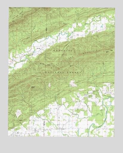
Gravelly, AR USGS Topographic Map
Click on map above to begin viewing in our Map Viewer.

This topographic map contains these locations and features:
Feature Name Type Latitude Longitude GNIS ID View Map
Blue BallPopulated PlaceN34.9623°W93.7085°76378View Map
Blue Ball Volunteer Fire StationBuildingN34.9569°W93.7156°2116161View Map
Briscoe CreekStreamN34.9551°W93.7238°70824View Map
Callahan GapGapN34.9576°W93.6360°70961View Map
Callahan KnobSummitN34.9587°W93.6274°70962View Map
Cane CreekStreamN34.9054°W93.6363°70986View Map
Cedar BranchStreamN34.9887°W93.6257°71053View Map
Cedar CreekStreamN34.9759°W93.6749°71061View Map
Chop Off MountainSummitN34.9223°W93.7241°71147View Map
Cudd CreekStreamN34.9151°W93.6355°71312View Map
Dutch Creek MountainRidgeN34.9537°W93.6560°71478View Map
Dutch Creek Mountain Scenic AreaLocaleN34.9401°W93.7180°74594View Map
Egypt CemeteryCemeteryN34.9668°W93.6944°71541View Map
Eli BranchStreamN34.9754°W93.6766°71548View Map
GravellyPopulated PlaceN34.8832°W93.6874°77059View Map
Gravelly Post OfficePost OfficeN34.8816°W93.6865°84405View Map
Honey Cut GapGapN34.9443°W93.6780°72057View Map
Lofland CreekStreamN34.8956°W93.6521°72440View Map
Mount Pleasant ChurchChurchN34.9765°W93.6469°72765View Map
Mount Vernon ChurchChurchN34.9151°W93.6583°67920View Map
Mulberry ChurchChurchN34.8973°W93.7005°72812View Map
NolaPopulated PlaceN34.8779°W93.7413°72876View Map
Oil Well HollowValleyN34.9520°W93.7294°72925View Map
Park CreekStreamN34.8931°W93.6624°72998View Map
Parks CemeteryCemeteryN34.8770°W93.7238°73005View Map
Pollard BranchStreamN34.9412°W93.7449°73155View Map
Red Hill CemeteryCemeteryN34.9151°W93.6571°2033666View Map
Rock CreekStreamN34.9143°W93.6305°73328View Map
Rocky Ford School (historical)SchoolN34.9731°W93.6733°67944View Map
Sinco BranchStreamN34.9787°W93.6696°73587View Map
Tate Town ChurchChurchN34.9432°W93.7485°73828View Map
Township of Dutch CreekCivilN34.9963°W93.6370°69875View Map
Township of Gravelly HillCivilN34.8900°W93.6735°69879View Map
Township of JonesCivilN34.8803°W93.7359°69067View Map
West Fourche Fire DepartmentBuildingN34.8833°W93.6906°2117294View Map
Young GravellyPopulated PlaceN34.9154°W93.6585°74227View Map
Young Gravelly CemeteryCemeteryN34.9151°W93.6574°2033694View Map

Note: Coordinates in the location and feature list above are referenced to NAD83 datum.


Copyright (C) 2008-2025 Ryan Niemi / Sunset Dynamics ... All Rights Reserved