TopoQuest Logo
Do you find TopoQuest useful?
Help keep TopoQuest running and adding new maps/features by donating!
Bitcoin:  19c7KJd3qBynnjoSw5npx9KScwjBe4ifkT
Litecoin:  LXs6TkuXGGXo1vDsWCkWVdjQX94eUKd6ui
Home View Maps Find Maps Find Places Resources & Links


Frog Hollow, Oregon Topographic Map

USGS Map Title: Frog Hollow, OR
USGS Map MRC: 44119E8
DRG (GeoTIFF) Download: o44119e8.tif


Neighboring USGS Topographic Map Quads:


  Toney Butte, OR  
44120F1
 

  Richmond, OR  
44119F8
 

  Johnson Heights, OR  
44119F7
 

  Keyes Mountain, OR  
44120E1
 

  Frog Hollow, OR  
44119E8
 

  Tubb Spring, OR  
44119E7
 

  Peterson Point, OR  
44120D1
 

  Derr Meadows, OR  
44119D8
 

  Antone, OR  
44119D7


Map MRC Location:

N45°
W120°
N45°
W119°
H8 H7 H6 H5 H4 H3 H2 H1
G8 G7 G6 G5 G4 G3 G2 G1
F8 F7 F6 F5 F4 F3 F2 F1
E8 E7 E6 E5 E4 E3 E2 E1
D8 D7 D6 D5 D4 D3 D2 D1
C8 C7 C6 C5 C4 C3 C2 C1
B8 B7 B6 B5 B4 B3 B2 B1
A8 A7 A6 A5 A4 A3 A2 A1
N44°
W120°
N44°
W119°

Frog Hollow, OR USGS 1:24K Topographic Map Preview:
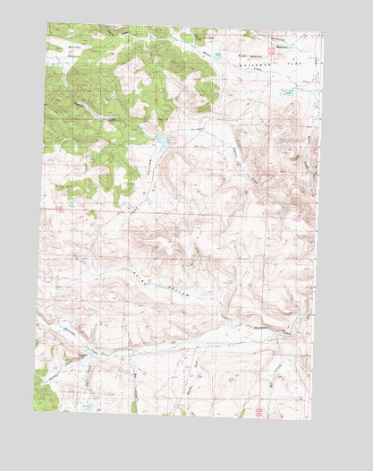
Frog Hollow, OR USGS Topographic Map
Click on map above to begin viewing in our Map Viewer.

This topographic map contains these locations and features:
Feature Name Type Latitude Longitude GNIS ID View Map
Bearway MeadowFlatN44.6129°W119.9919°1117407View Map
Blann CreekStreamN44.6199°W119.9511°1131023View Map
Blann MeadowFlatN44.6107°W119.9044°1158128View Map
Blann Meadow ReservoirReservoirN44.6160°W119.9228°1159103View Map
Blann Meadow Reservoir DamDamN44.6164°W119.9214°1159104View Map
Caleb (historical)Populated PlaceN44.5235°W119.9122°1131017View Map
Caleb CemeteryCemeteryN44.5235°W119.9396°1118459View Map
Caleb Post Office (historical)Post OfficeN44.5235°W119.9122°1164998View Map
Collins DamDamN44.5020°W119.9761°1133492View Map
Collins Landing Strip (historical)AirportN44.5165°W119.9761°1158819View Map
Collins ReservoirReservoirN44.5007°W119.9758°1131016View Map
Dry Lake (historical)LakeN44.5070°W119.8797°1133797View Map
Fopiano DamDamN44.5898°W119.9441°1133539View Map
Fopiano RanchLocaleN44.5926°W119.9289°1638499View Map
Fopiano ReservoirReservoirN44.5878°W119.9460°1129504View Map
Fort CreekStreamN44.5274°W119.8917°1142317View Map
Fort Creek DamDamN44.5087°W119.8839°1133542View Map
Fort Creek ReservoirReservoirN44.5079°W119.8804°1129503View Map
Frog HollowValleyN44.5776°W119.9492°1121007View Map
Fry CreekStreamN44.5187°W119.9719°1142513View Map
Keeton CreekStreamN44.5182°W119.9744°1144511View Map
Mac CreekStreamN44.5199°W119.9561°1145703View Map
McKay CreekStreamN44.6207°W119.9511°1131024View Map
North Fork Willow CreekStreamN44.6021°W119.8761°1131019View Map
One-Oh-One RanchLocaleN44.5260°W119.9083°1638819View Map
Rhine HollowValleyN44.5276°W119.9122°1129332View Map
Sheet Iron Jack CreekStreamN44.6193°W119.9372°1126854View Map
Sixshooter CreekStreamN44.6110°W119.8775°1131020View Map
Spoos MillPopulated PlaceN44.5182°W119.9761°1161528View Map
Waterman (historical)Populated PlaceN44.6193°W119.8903°1161577View Map
Waterman FlatFlatN44.6126°W119.8875°1128727View Map
Waterman Post Office (historical)Post OfficeN44.6193°W119.8903°1166134View Map
Whisky CreekStreamN44.5268°W119.9206°1152205View Map

Note: Coordinates in the location and feature list above are referenced to NAD83 datum.


Copyright (C) 2008-2024 Ryan Niemi / Sunset Dynamics ... All Rights Reserved