TopoQuest Logo
Do you find TopoQuest useful?
Help keep TopoQuest running and adding new maps/features by donating!
Bitcoin:  19c7KJd3qBynnjoSw5npx9KScwjBe4ifkT
Litecoin:  LXs6TkuXGGXo1vDsWCkWVdjQX94eUKd6ui
Home View Maps Find Maps Find Places Resources & Links


Derr Meadows, Oregon Topographic Map

USGS Map Title: Derr Meadows, OR
USGS Map MRC: 44119D8
DRG (GeoTIFF) Download: o44119d8.tif


Neighboring USGS Topographic Map Quads:


  Keyes Mountain, OR  
44120E1
 

  Frog Hollow, OR  
44119E8
 

  Tubb Spring, OR  
44119E7
 

  Peterson Point, OR  
44120D1
 

  Derr Meadows, OR  
44119D8
 

  Antone, OR  
44119D7
 

  Keys Creek, OR  
44120C1
 

  Little Summit Prairie, OR  
44119C8
 

  Six Corners, OR  
44119C7


Map MRC Location:

N45°
W120°
N45°
W119°
H8 H7 H6 H5 H4 H3 H2 H1
G8 G7 G6 G5 G4 G3 G2 G1
F8 F7 F6 F5 F4 F3 F2 F1
E8 E7 E6 E5 E4 E3 E2 E1
D8 D7 D6 D5 D4 D3 D2 D1
C8 C7 C6 C5 C4 C3 C2 C1
B8 B7 B6 B5 B4 B3 B2 B1
A8 A7 A6 A5 A4 A3 A2 A1
N44°
W120°
N44°
W119°

Derr Meadows, OR USGS 1:24K Topographic Map Preview:
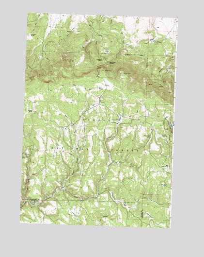
Derr Meadows, OR USGS Topographic Map
Click on map above to begin viewing in our Map Viewer.

This topographic map contains these locations and features:
Feature Name Type Latitude Longitude GNIS ID View Map
Alder SpringSpringN44.4301°W119.8839°1137103View Map
Aspen Grove SpringSpringN44.4148°W119.9992°1137329View Map
Barnhouse Recreation SiteLocaleN44.4735°W119.9344°1167659View Map
Barnhouse SpringSpringN44.4733°W119.9366°1137538View Map
Blevins SpringSpringN44.4566°W119.9387°1138261View Map
Buck PointSummitN44.4671°W119.9347°1138812View Map
Buck Point TroughsSpringN44.4717°W119.9308°1138816View Map
Cabbage CreekStreamN44.4251°W119.9961°1161235View Map
Camp Watson (historical)MilitaryN44.4853°W119.8939°1139274View Map
Camp Watson CemeteryCemeteryN44.4844°W119.8995°2507707View Map
Camp Watson PointCapeN44.4660°W119.9186°1139275View Map
Camp Watson Post Office (historical)Post OfficeN44.4851°W119.8950°1165005View Map
Chamberlin SpringSpringN44.4285°W119.8943°1139554View Map
Chambers SpringSpringN44.4866°W119.9966°1139557View Map
Derr CampLocaleN44.4365°W119.9233°1140908View Map
Derr CreekStreamN44.4131°W119.9256°1161233View Map
Derr Guard StationLocaleN44.4382°W119.9214°1140909View Map
Derr MeadowsSwampN44.4375°W119.9207°1140910View Map
Dicer MeadowFlatN44.3821°W119.8933°1141012View Map
Double CorralLocaleN44.3954°W119.9661°1141201View Map
Double Corral CreekStreamN44.3962°W119.9664°1154293View Map
Fry SpringSpringN44.4632°W119.9836°1142519View Map
Happy Camp CreekStreamN44.3887°W119.9955°1143275View Map
Happy Jack CampLocaleN44.4160°W119.9986°1143283View Map
Haypress CreekStreamN44.4318°W119.9558°1143407View Map
Jackson CreekStreamN44.3887°W119.9955°1144197View Map
Sam Davis SpringSpringN44.4011°W119.8788°1149019View Map
Toggle CreekStreamN44.3943°W119.9367°1161236View Map
Toggle MeadowsFlatN44.3868°W119.9119°1151296View Map
West Buker SpringSpringN44.4117°W119.8779°1152034View Map
Younger SpringSpringN44.4415°W119.9923°1152756View Map

Note: Coordinates in the location and feature list above are referenced to NAD83 datum.


Copyright (C) 2008-2024 Ryan Niemi / Sunset Dynamics ... All Rights Reserved