TopoQuest Logo
Do you find TopoQuest useful?
Help keep TopoQuest running and adding new maps/features by donating!
Bitcoin:  19c7KJd3qBynnjoSw5npx9KScwjBe4ifkT
Litecoin:  LXs6TkuXGGXo1vDsWCkWVdjQX94eUKd6ui
Home View Maps Find Maps Find Places Resources & Links


Toney Butte, Oregon Topographic Map

USGS Map Title: Toney Butte, OR
USGS Map MRC: 44120F1
DRG (GeoTIFF) Download: o44120f1.tif


Neighboring USGS Topographic Map Quads:


  Rowe Creek, OR  
44120G2
 

  Service Creek, OR  
44120G1
 

  Masiker Mountain, OR  
44119G8
 

  Sutton Mountain, OR  
44120F2
 

  Toney Butte, OR  
44120F1
 

  Richmond, OR  
44119F8
 

  Mitchell, OR  
44120E2
 

  Keyes Mountain, OR  
44120E1
 

  Frog Hollow, OR  
44119E8


Map MRC Location:

N45°
W121°
N45°
W120°
H8 H7 H6 H5 H4 H3 H2 H1
G8 G7 G6 G5 G4 G3 G2 G1
F8 F7 F6 F5 F4 F3 F2 F1
E8 E7 E6 E5 E4 E3 E2 E1
D8 D7 D6 D5 D4 D3 D2 D1
C8 C7 C6 C5 C4 C3 C2 C1
B8 B7 B6 B5 B4 B3 B2 B1
A8 A7 A6 A5 A4 A3 A2 A1
N44°
W121°
N44°
W120°

Toney Butte, OR USGS 1:24K Topographic Map Preview:
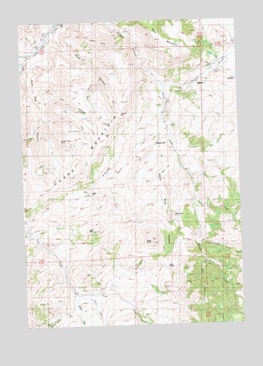
Toney Butte, OR USGS Topographic Map
Click on map above to begin viewing in our Map Viewer.

This topographic map contains these locations and features:
Feature Name Type Latitude Longitude GNIS ID View Map
Bald GapGapN44.7024°W120.0772°1117171View Map
Black RockPillarN44.6696°W120.0397°1117771View Map
Black Rock CanyonValleyN44.7054°W120.0447°1117776View Map
Camel HumpSummitN44.7396°W120.0742°1118486View Map
Clark CanyonValleyN44.7449°W120.1072°1118964View Map
Dead Dog CanyonValleyN44.7362°W120.1178°1119734View Map
Gordy FlatFlatN44.6887°W120.0428°1160515View Map
Green HollowValleyN44.6393°W120.0797°1121379View Map
Horse MountainSummitN44.6812°W120.1156°1136395View Map
Juniper GapGapN44.7115°W120.0681°1158305View Map
Keys MountainSummitN44.7499°W120.0511°1136438View Map
Keys ReservoirReservoirN44.7261°W120.0019°1159069View Map
Limekiln CreekStreamN44.6510°W120.0217°1123090View Map
Mabe HillSummitN44.6787°W120.0870°1160516View Map
May SpringSpringN44.6912°W120.1137°1123868View Map
Melvina CreekStreamN44.7076°W120.0431°1124053View Map
Monroe CreekStreamN44.6379°W120.0958°1124295View Map
Old Frizzell RanchLocaleN44.6393°W120.0967°1124964View Map
Payne CreekStreamN44.6374°W120.0947°1125249View Map
Quaking Aspen SpringSpringN44.7008°W120.1037°1125723View Map
Rattlesnake CreekStreamN44.6585°W120.0250°1125831View Map
Red Mud CreekStreamN44.6746°W120.0283°1125895View Map
Richmond CemeteryCemeteryN44.7293°W120.0121°1125987View Map
Rock SpringSpringN44.6478°W120.0437°1126209View Map
School Section CabinLocaleN44.7049°W120.0895°1126653View Map
Scott ButteSummitN44.6640°W120.0847°1126676View Map
Shoofly RanchLocaleN44.6737°W120.0270°1126911View Map
Tamarack CreekStreamN44.7243°W120.0447°1127877View Map
The Blue BanksCliffN44.6937°W120.0647°1127952View Map
Tilley CanyonValleyN44.7260°W120.0797°1128096View Map
Toney ButteSummitN44.6587°W120.0533°1128162View Map
Trail CanyonValleyN44.7176°W120.1147°1128181View Map
Trent CreekStreamN44.6860°W120.0289°1158710View Map
Waldron (historical)Populated PlaceN44.7243°W120.0286°1136874View Map
Waldron Post Office (historical)Post OfficeN44.7243°W120.0286°1166116View Map
Waldron School (historical)SchoolN44.6993°W120.0481°1128583View Map
Wheeler CountyCivilN44.7261°W120.0276°1135865View Map
Wheeler Post Office (historical)Post OfficeN44.6387°W120.0970°1164778View Map

Note: Coordinates in the location and feature list above are referenced to NAD83 datum.


Copyright (C) 2008-2024 Ryan Niemi / Sunset Dynamics ... All Rights Reserved