TopoQuest Logo
Do you find TopoQuest useful?
Help keep TopoQuest running and adding new maps/features by donating!
Bitcoin:  19c7KJd3qBynnjoSw5npx9KScwjBe4ifkT
Litecoin:  LXs6TkuXGGXo1vDsWCkWVdjQX94eUKd6ui
Home View Maps Find Maps Find Places Resources & Links


Beans Ferry, Mississippi Topographic Map

USGS Map Title: Beans Ferry, MS
USGS Map MRC: 34088B4
DRG (GeoTIFF) Download: o34088b4.tif


Neighboring USGS Topographic Map Quads:


  Mooreville, MS  
34088C5
 

  Fulton, MS  
34088C4
 

  Fulton SE, MS  
34088C3
 

  Evergreen, MS  
34088B5
 

  Beans Ferry, MS  
34088B4
 

  Tremont, MS  
34088B3
 

  Nettleton, MS  
34088A5
 

  Smithville, MS  
34088A4
 

  Turon, MS  
34088A3


Map MRC Location:

N35°
W89°
N35°
W88°
H8 H7 H6 H5 H4 H3 H2 H1
G8 G7 G6 G5 G4 G3 G2 G1
F8 F7 F6 F5 F4 F3 F2 F1
E8 E7 E6 E5 E4 E3 E2 E1
D8 D7 D6 D5 D4 D3 D2 D1
C8 C7 C6 C5 C4 C3 C2 C1
B8 B7 B6 B5 B4 B3 B2 B1
A8 A7 A6 A5 A4 A3 A2 A1
N34°
W89°
N34°
W88°

Beans Ferry, MS USGS 1:24K Topographic Map Preview:
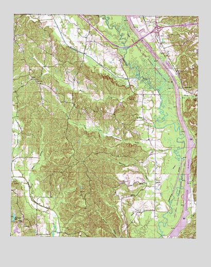
Beans Ferry, MS USGS Topographic Map
Click on map above to begin viewing in our Map Viewer.

This topographic map contains these locations and features:
Feature Name Type Latitude Longitude GNIS ID View Map
AbneyPopulated PlaceN34.2134°W88.4870°691657View Map
Bean CemeteryCemeteryN34.1504°W88.4534°666627View Map
Beans FerryPopulated PlaceN34.2098°W88.3850°666629View Map
Beans Ferry Church of ChristChurchN34.2115°W88.3850°683684View Map
Beenes Ferry (historical)CrossingN34.2059°W88.4003°706218View Map
Black BranchStreamN34.1437°W88.4825°667206View Map
Booth CemeteryCemeteryN34.2023°W88.4175°667442View Map
Bourland CemeteryCemeteryN34.1562°W88.4248°667467View Map
Bourland CreekStreamN34.1629°W88.3881°667468View Map
CardsvillePopulated PlaceN34.1557°W88.4025°691749View Map
Cardsville ChurchChurchN34.1484°W88.4189°668057View Map
Cardsville Volunteer Fire DepartmentBuildingN34.1669°W88.4034°2666012View Map
Carolina ChurchChurchN34.1329°W88.4934°668075View Map
Dorsey - Friendship Fire Department Hopewell Keys StationBuildingN34.1984°W88.4575°2666008View Map
Enon ChurchChurchN34.1554°W88.4109°669790View Map
Green CreekStreamN34.1746°W88.3898°670660View Map
Greenwood CreekStreamN34.1584°W88.4981°670725View Map
Henry Shackleford Lake DamDamN34.1284°W88.4884°682478View Map
Hopewell ChurchChurchN34.2123°W88.4839°671439View Map
Keys CemeteryCemeteryN34.2018°W88.4645°706243View Map
Keys ChurchChurchN34.2009°W88.4645°672114View Map
Mantachie CreekStreamN34.2146°W88.4153°673116View Map
McHenry Lookout TowerTowerN34.1976°W88.4573°711275View Map
Moores CreekStreamN34.2140°W88.4150°673791View Map
Muscadine Bower School (historical)SchoolN34.2037°W88.3781°706258View Map
Pennington LakeReservoirN34.1357°W88.4982°675592View Map
Pool CReservoirN34.1287°W88.3887°682538View Map
Reeds CemeteryCemeteryN34.2029°W88.3775°676566View Map
Reeds CreekStreamN34.2068°W88.3973°676568View Map
Supervisor District 3CivilN34.1863°W88.4698°711897View Map
Van BurenPopulated PlaceN34.1918°W88.4114°679181View Map
WFTO-AM (Fulton)TowerN34.2473°W88.4073°680157View Map
Wheeling (historical)LocaleN34.1409°W88.3789°706280View Map
White Springs (historical)LocaleN34.1543°W88.3773°706281View Map
Wiygul CemeteryCemeteryN34.1307°W88.4873°679801View Map

Note: Coordinates in the location and feature list above are referenced to NAD83 datum.


Copyright (C) 2008-2024 Ryan Niemi / Sunset Dynamics ... All Rights Reserved