TopoQuest Logo
Do you find TopoQuest useful?
Help keep TopoQuest running and adding new maps/features by donating!
Bitcoin:  19c7KJd3qBynnjoSw5npx9KScwjBe4ifkT
Litecoin:  LXs6TkuXGGXo1vDsWCkWVdjQX94eUKd6ui
Home View Maps Find Maps Find Places Resources & Links


Gaither, Arkansas Topographic Map

USGS Map Title: Gaither, AR
USGS Map MRC: 36093B2
DRG (GeoTIFF) Download: o36093b2.tif


Neighboring USGS Topographic Map Quads:


  Alpena, AR  
36093C3
 

  Batavia, AR  
36093C2
 

  Bergman, AR  
36093C1
 

  Osage NE, AR  
36093B3
 

  Gaither, AR  
36093B2
 

  Harrison, AR  
36093B1
 

  Ponca, AR  
36093A3
 

  Jasper, AR  
36093A2
 

  Hasty, AR  
36093A1


Map MRC Location:

N37°
W94°
N37°
W93°
H8 H7 H6 H5 H4 H3 H2 H1
G8 G7 G6 G5 G4 G3 G2 G1
F8 F7 F6 F5 F4 F3 F2 F1
E8 E7 E6 E5 E4 E3 E2 E1
D8 D7 D6 D5 D4 D3 D2 D1
C8 C7 C6 C5 C4 C3 C2 C1
B8 B7 B6 B5 B4 B3 B2 B1
A8 A7 A6 A5 A4 A3 A2 A1
N36°
W94°
N36°
W93°

Gaither, AR USGS 1:24K Topographic Map Preview:
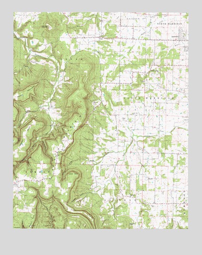
Gaither, AR USGS Topographic Map
Click on map above to begin viewing in our Map Viewer.

This topographic map contains these locations and features:
Feature Name Type Latitude Longitude GNIS ID View Map
Beaver Lodge LakeReservoirN36.1917°W93.2102°80927View Map
Beaver Lodge Lake DamDamN36.1917°W93.2102°80926View Map
CappsPopulated PlaceN36.2356°W93.1893°57506View Map
Capps - Batavia Fire Department Station 1BuildingN36.2373°W93.1870°2116232View Map
Capps Presbyterian ChurchChurchN36.2359°W93.1885°69266View Map
Capps Road Church of ChristChurchN36.2353°W93.1305°69267View Map
Coker CemeteryCemeteryN36.2248°W93.2368°47896View Map
Cone PointSummitN36.1334°W93.1982°71210View Map
Dowell BranchStreamN36.1706°W93.1696°48594View Map
Dowell CoveValleyN36.1631°W93.1907°48595View Map
East Fork Terrapin CreekStreamN36.1967°W93.2252°48764View Map
Fernsides CoveValleyN36.1771°W93.2315°49031View Map
GaitherPopulated PlaceN36.1437°W93.1668°57785View Map
Gaither Baptist ChurchChurchN36.1445°W93.1724°69289View Map
Gaither CemeteryCemeteryN36.1503°W93.1743°49304View Map
Gaither CoveValleyN36.1458°W93.1924°49305View Map
Gaither MountainSummitN36.1709°W93.2205°57786View Map
Gaither PrairieAreaN36.1565°W93.1580°69290View Map
Grubb SpringsPopulated PlaceN36.2151°W93.1546°49696View Map
Grubb Springs Baptist ChurchChurchN36.2140°W93.1566°69292View Map
Hambrick KnobSummitN36.1270°W93.1674°57871View Map
Harrison High SchoolSchoolN36.2395°W93.1334°69295View Map
Hill Top Fire Department Station 2BuildingN36.1539°W93.2289°2116577View Map
Holt CemeteryCemeteryN36.1870°W93.1649°50266View Map
Johnson CoveValleyN36.1651°W93.2410°50691View Map
Jones PointCapeN36.1567°W93.2071°50738View Map
Kennedy MountainSummitN36.2412°W93.2257°50808View Map
Krooked Kreek Fire Station GaitherBuildingN36.1437°W93.1714°2116671View Map
Long CemeteryCemeteryN36.1759°W93.1699°51418View Map
Piney MountainSummitN36.2034°W93.2424°58387View Map
Plumly SchoolSchoolN36.2348°W93.2477°53632View Map
Robinson CemeteryCemeteryN36.1978°W93.1938°54077View Map
Rogers CemeteryCemeteryN36.1381°W93.1488°54163View Map
Sims CoveValleyN36.1922°W93.2410°54871View Map
Stewart PointCapeN36.1792°W93.2416°55217View Map
Terrapin CoveValleyN36.1837°W93.2218°55495View Map
Township of BryanCivilN36.2201°W93.2038°69607View Map
Township of Crooked Creek (historical)CivilN36.1876°W93.1710°69273View Map
Township of GaitherCivilN36.1424°W93.1558°69611View Map
Township of South HarrisonCivilN36.1963°W93.1304°69620View Map
Valley View United Methodist ChurchChurchN36.1915°W93.1652°78646View Map
Wagley CemeteryCemeteryN36.1887°W93.1704°55937View Map
West Fork Terrapin CreekStreamN36.1970°W93.2252°56187View Map
White ChurchChurchN36.1531°W93.1538°56251View Map

Note: Coordinates in the location and feature list above are referenced to NAD83 datum.


Copyright (C) 2008-2025 Ryan Niemi / Sunset Dynamics ... All Rights Reserved