TopoQuest Logo
Do you find TopoQuest useful?
Help keep TopoQuest running and adding new maps/features by donating!
Bitcoin:  19c7KJd3qBynnjoSw5npx9KScwjBe4ifkT
Litecoin:  LXs6TkuXGGXo1vDsWCkWVdjQX94eUKd6ui
Home View Maps Find Maps Find Places Resources & Links


Jasper, Arkansas Topographic Map

USGS Map Title: Jasper, AR
USGS Map MRC: 36093A2
DRG (GeoTIFF) Download: o36093a2.tif


Neighboring USGS Topographic Map Quads:


  Osage NE, AR  
36093B3
 

  Gaither, AR  
36093B2
 

  Harrison, AR  
36093B1
 

  Ponca, AR  
36093A3
 

  Jasper, AR  
36093A2
 

  Hasty, AR  
36093A1
 

  Murray, AR  
35093H3
 

  Parthenon, AR  
35093H2
 

  Mount Judea, AR  
35093H1


Map MRC Location:

N37°
W94°
N37°
W93°
H8 H7 H6 H5 H4 H3 H2 H1
G8 G7 G6 G5 G4 G3 G2 G1
F8 F7 F6 F5 F4 F3 F2 F1
E8 E7 E6 E5 E4 E3 E2 E1
D8 D7 D6 D5 D4 D3 D2 D1
C8 C7 C6 C5 C4 C3 C2 C1
B8 B7 B6 B5 B4 B3 B2 B1
A8 A7 A6 A5 A4 A3 A2 A1
N36°
W94°
N36°
W93°

Jasper, AR USGS 1:24K Topographic Map Preview:
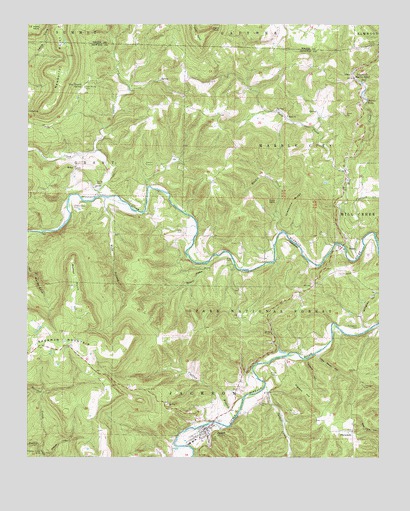
Jasper, AR USGS Topographic Map
Click on map above to begin viewing in our Map Viewer.

This topographic map contains these locations and features:
Feature Name Type Latitude Longitude GNIS ID View Map
Adair CemeteryCemeteryN36.0653°W93.1949°70410View Map
Basin ChurchChurchN36.0987°W93.1577°70525View Map
Basin School (historical)SchoolN36.0987°W93.1580°69915View Map
Boulder CreekStreamN36.0020°W93.2455°70775View Map
Briar BluffCliffN36.0654°W93.1591°81814View Map
Brown CemeteryCemeteryN36.0565°W93.1785°70840View Map
Buck PointCapeN36.0759°W93.1643°70897View Map
Buffalo Ranger District OfficeBuildingN36.0173°W93.1782°74478View Map
Carlton BranchStreamN36.0106°W93.1763°71012View Map
Cave SpringSpringN36.0881°W93.2327°81815View Map
Cecil CreekStreamN36.0884°W93.2257°76555View Map
Cherry Grove CemeteryCemeteryN36.0723°W93.2335°71124View Map
City of JasperCivilN36.0105°W93.1860°2404791View Map
Conard Fissure (historical)MineN36.0848°W93.2080°71207View Map
Cove CreekStreamN36.0754°W93.2257°71248View Map
Cove SpringSpringN36.0804°W93.2205°81818View Map
DogpatchPopulated PlaceN36.1098°W93.1349°76808View Map
Dogwood FlatFlatN36.0184°W93.1516°71403View Map
Edwards LakeReservoirN36.1151°W93.2068°80929View Map
Edwards Lake DamDamN36.1151°W93.2068°80928View Map
ErbiePopulated PlaceN36.0837°W93.2332°71565View Map
Erbie Community ChurchChurchN36.0831°W93.2330°69920View Map
Flatrock CreekStreamN36.0734°W93.1371°71629View Map
FlatwoodsPopulated PlaceN36.0073°W93.1346°71633View Map
Goat BluffCliffN36.0759°W93.2352°81821View Map
Grapevine RidgeRidgeN36.0745°W93.1557°71806View Map
Harp CreekStreamN36.0829°W93.1363°71912View Map
Henry Koen Experimental ForestParkN36.0362°W93.1863°74424View Map
Henry Koen Experimental ForestForestN36.0398°W93.1735°81823View Map
Hoskin CreekStreamN36.0648°W93.1605°72090View Map
JasperPopulated PlaceN36.0081°W93.1866°72172View Map
Jasper Elementary SchoolSchoolN36.0052°W93.1904°69923View Map
Jasper Fire StationBuildingN36.0090°W93.1876°2116629View Map
Jasper High SchoolSchoolN36.0045°W93.1907°69924View Map
Jasper Police DepartmentBuildingN36.0089°W93.1875°2118843View Map
Little Blade HollowValleyN36.0301°W93.1468°72369View Map
Little Buffalo (historical)Populated PlaceN36.0479°W93.1263°69925View Map
Marble FallsFallsN36.1030°W93.1296°72551View Map
Mill CreekStreamN36.0579°W93.1324°72669View Map
Mill Creek Hollow DamDamN36.0751°W93.1368°80930View Map
Mill Creek Hollow ReservoirReservoirN36.0751°W93.1368°80931View Map
Mutton PointSummitN36.0542°W93.2341°72826View Map
Newberry PointCapeN36.1159°W93.2357°72862View Map
Newton County Sheriff's OfficeBuildingN36.0088°W93.1867°2118842View Map
North PondReservoirN36.0551°W93.1799°81829View Map
Panther Creek MineMineN36.0020°W93.2460°72989View Map
Point RockPillarN36.1234°W93.1849°73147View Map
PruittPopulated PlaceN36.0623°W93.1368°73208View Map
Pruitt CemeteryCemeteryN36.0237°W93.1632°73209View Map
Sawmill HollowValleyN36.0562°W93.1863°73488View Map
Shaddox CemeteryCemeteryN36.0617°W93.1332°81831View Map
Sherman MountainSummitN36.0340°W93.2455°83615View Map
South PondReservoirN36.0534°W93.1785°81832View Map
Spider CreekStreamN36.0201°W93.1657°73665View Map
Spring BluffCliffN36.1095°W93.1321°69941View Map
Stringtown CemeteryCemeteryN36.0373°W93.1329°73739View Map
Stringtown HollowValleyN36.0379°W93.1313°73740View Map
Tadpole HollowValleyN36.0279°W93.1513°73815View Map
The BasinPopulated PlaceN36.0981°W93.1585°69943View Map
Tom Thumb CemeteryCemeteryN36.1070°W93.2296°73879View Map
Tom Thumb SpringSpringN36.1072°W93.2311°73880View Map
Township of Grant (historical)CivilN36.0848°W93.2335°69921View Map
Township of JacksonCivilN36.0041°W93.1829°69678View Map
Township of Marble City (historical)CivilN36.0917°W93.1502°69684View Map
Township of Marble FallsCivilN36.0842°W93.1502°2406958View Map
Van Dyke SpringSpringN36.0856°W93.2399°81833View Map
Weatherby LakeReservoirN36.0303°W93.2419°79630View Map
Weatherby Lake DamDamN36.0301°W93.2418°79629View Map
Webb BranchStreamN36.0751°W93.2221°74034View Map
Welch BluffCliffN36.0640°W93.1260°81834View Map
Wildcat HollowValleyN36.0005°W93.2439°74151View Map
Young CemeteryCemeteryN36.0792°W93.2254°74226View Map

Note: Coordinates in the location and feature list above are referenced to NAD83 datum.


Copyright (C) 2008-2024 Ryan Niemi / Sunset Dynamics ... All Rights Reserved