TopoQuest Logo
Do you find TopoQuest useful?
Help keep TopoQuest running and adding new maps/features by donating!
Bitcoin:  19c7KJd3qBynnjoSw5npx9KScwjBe4ifkT
Litecoin:  LXs6TkuXGGXo1vDsWCkWVdjQX94eUKd6ui
Home View Maps Find Maps Find Places Resources & Links


Osage NE, Arkansas Topographic Map

USGS Map Title: Osage NE, AR
USGS Map MRC: 36093B3
DRG (GeoTIFF) Download: o36093b3.tif


Neighboring USGS Topographic Map Quads:


  Green Forest, AR  
36093C4
 

  Alpena, AR  
36093C3
 

  Batavia, AR  
36093C2
 

  Osage, AR  
36093B4
 

  Osage NE, AR  
36093B3
 

  Gaither, AR  
36093B2
 

  Osage SW, AR  
36093A4
 

  Ponca, AR  
36093A3
 

  Jasper, AR  
36093A2


Map MRC Location:

N37°
W94°
N37°
W93°
H8 H7 H6 H5 H4 H3 H2 H1
G8 G7 G6 G5 G4 G3 G2 G1
F8 F7 F6 F5 F4 F3 F2 F1
E8 E7 E6 E5 E4 E3 E2 E1
D8 D7 D6 D5 D4 D3 D2 D1
C8 C7 C6 C5 C4 C3 C2 C1
B8 B7 B6 B5 B4 B3 B2 B1
A8 A7 A6 A5 A4 A3 A2 A1
N36°
W94°
N36°
W93°

Osage NE, AR USGS 1:24K Topographic Map Preview:
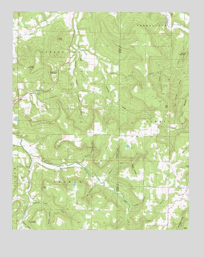
Osage NE, AR USGS Topographic Map
Click on map above to begin viewing in our Map Viewer.

This topographic map contains these locations and features:
Feature Name Type Latitude Longitude GNIS ID View Map
Alford CoveValleyN36.1537°W93.3085°45821View Map
Bee BluffCliffN36.1492°W93.3530°46295View Map
Big SpringSpringN36.2231°W93.3277°46607View Map
Big Spring DrawValleyN36.2128°W93.2535°46610View Map
Brewer LakeReservoirN36.1517°W93.3285°79653View Map
Brewer Lake DamDamN36.1517°W93.3285°79652View Map
Butler CoveValleyN36.1573°W93.2502°47233View Map
DelmarPopulated PlaceN36.1606°W93.3410°56987View Map
Denton CoveValleyN36.2201°W93.3127°48477View Map
Dishrown CreekStreamN36.2295°W93.3288°48523View Map
Dodson MountainSummitN36.1295°W93.3580°57668View Map
Dog Branch CemeteryCemeteryN36.2037°W93.3582°48552View Map
Ferguson HollowValleyN36.1645°W93.3005°49029View Map
Gibbs CemeteryCemeteryN36.1809°W93.3182°49388View Map
Hill TopPopulated PlaceN36.1426°W93.2557°69298View Map
Hill Top Church of ChristChurchN36.1456°W93.2541°77188View Map
Hill Top Fire Department Station 1BuildingN36.1491°W93.2532°2116576View Map
Hilltop CemeteryCemeteryN36.1495°W93.2549°50133View Map
Holden MountainSummitN36.2212°W93.3582°50185View Map
McMillion CemeteryCemeteryN36.1551°W93.3691°51869View Map
Micks BranchStreamN36.1259°W93.2877°51923View Map
Needle Eye MountainSummitN36.2170°W93.3493°58245View Map
Outlaw HollowValleyN36.1362°W93.3480°53094View Map
Owl HollowValleyN36.1515°W93.3163°53113View Map
Parton HollowValleyN36.1384°W93.2902°53206View Map
Phelps HollowValleyN36.1640°W93.2910°53318View Map
Pilot KnobSummitN36.2348°W93.3432°58368View Map
Pitcher HollowValleyN36.1287°W93.3677°53509View Map
Possum Trot ChurchChurchN36.1404°W93.3602°53713View Map
Possum Trot CreekStreamN36.1684°W93.3627°78080View Map
Red BankPopulated PlaceN36.1962°W93.2668°58470View Map
Rocky ForkStreamN36.1412°W93.3616°54137View Map
Round MountainSummitN36.2265°W93.2518°54243View Map
Shady Grove CemeteryCemeteryN36.1644°W93.3533°2761417View Map
Shady Grove ChurchChurchN36.1648°W93.3530°54721View Map
Township of CarrolltonCivilN36.2440°W93.3476°66891View Map
Township of Delmar (historical)CivilN36.1501°W93.3335°66896View Map
Township of SummitCivilN36.1687°W93.2593°69622View Map
Tucker CoveValleyN36.2187°W93.2680°55681View Map
Whooping HollowValleyN36.2051°W93.3316°56339View Map
Winding Staircase HollowValleyN36.1634°W93.3263°56456View Map

Note: Coordinates in the location and feature list above are referenced to NAD83 datum.


Copyright (C) 2008-2025 Ryan Niemi / Sunset Dynamics ... All Rights Reserved