TopoQuest Logo
Do you find TopoQuest useful?
Help keep TopoQuest running and adding new maps/features by donating!
Bitcoin:  19c7KJd3qBynnjoSw5npx9KScwjBe4ifkT
Litecoin:  LXs6TkuXGGXo1vDsWCkWVdjQX94eUKd6ui
Home View Maps Find Maps Find Places Resources & Links


Galax, Virginia Topographic Map

USGS Map Title: Galax, VA
USGS Map MRC: 36080F8
DRG (GeoTIFF) Download: o36080f8.tif


Neighboring USGS Topographic Map Quads:


  Cripple Creek, VA  
36081G1
 

  Austinville, VA  
36080G8
 

  Sylvatus, VA  
36080G7
 

  Brierpatch Mountain, VA  
36081F1
 

  Galax, VA  
36080F8
 

  Woodlawn, VA  
36080F7
 

  Sparta East, NC  
36081E1
 

  Cumberland Knob, NC  
36080E8
 

  Lambsburg, VA  
36080E7


Map MRC Location:

N37°
W81°
N37°
W80°
H8 H7 H6 H5 H4 H3 H2 H1
G8 G7 G6 G5 G4 G3 G2 G1
F8 F7 F6 F5 F4 F3 F2 F1
E8 E7 E6 E5 E4 E3 E2 E1
D8 D7 D6 D5 D4 D3 D2 D1
C8 C7 C6 C5 C4 C3 C2 C1
B8 B7 B6 B5 B4 B3 B2 B1
A8 A7 A6 A5 A4 A3 A2 A1
N36°
W81°
N36°
W80°

Galax, VA USGS 1:24K Topographic Map Preview:
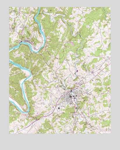
Galax, VA USGS Topographic Map
Click on map above to begin viewing in our Map Viewer.

This topographic map contains these locations and features:
Feature Name Type Latitude Longitude GNIS ID View Map
Austin School (historical)SchoolN36.6462°W80.9962°1501150View Map
Bald RockSummitN36.7462°W80.9487°1494821View Map
Beulah ChurchChurchN36.6990°W80.9787°1481679View Map
Bishop School (historical)SchoolN36.6654°W80.8792°1738599View Map
Bishops ChapelChurchN36.6640°W80.8865°1481817View Map
Bishops Chapel CemeteryCemeteryN36.6640°W80.8873°1738600View Map
Blair CemeteryCemeteryN36.6932°W80.9240°1738601View Map
Blair Ferry (historical)CrossingN36.7057°W80.9651°1501156View Map
Burnett CemeteryCemeteryN36.7248°W80.8876°1738617View Map
Calvary ChurchChurchN36.6643°W80.9037°1482233View Map
Camp Zion ChurchChurchN36.6262°W80.9231°1482282View Map
Chestnut YardLocaleN36.7226°W80.9170°1482511View Map
Church of the Good ShepherdChurchN36.6621°W80.9281°1738541View Map
City of GalaxCivilN36.6660°W80.9176°1498426View Map
Clear ForkStreamN36.6376°W80.9656°1482564View Map
CliffviewPopulated PlaceN36.6812°W80.9148°1494881View Map
Cliffview ChurchChurchN36.6957°W80.9334°1482577View Map
Coal CreekStreamN36.6312°W80.8998°1482603View Map
Coal Creek CemeteryCemeteryN36.6282°W80.8759°1738632View Map
Coal Creek ChurchChurchN36.6287°W80.8759°1738633View Map
Coal Creek Memorial CemeteryCemeteryN36.6273°W80.8762°1738634View Map
Coal Creek SchoolSchoolN36.6285°W80.8756°1482604View Map
Coby KnobSummitN36.6340°W80.9081°1494885View Map
Cooperative Center for Exceptional ChildrenSchoolN36.6546°W80.9243°2498452View Map
Cox MillPopulated PlaceN36.6312°W80.8995°1482775View Map
CT FieldsAirportN36.6352°W80.9144°2787188View Map
Daniel BranchStreamN36.7451°W80.8781°1482911View Map
Dean Cox CemeteryCemeteryN36.6268°W80.8823°1738661View Map
Dickinson Ferry (historical)CrossingN36.6743°W80.9837°1501177View Map
Dixon BranchStreamN36.7171°W80.9542°1483038View Map
Dixon CemeteryCemeteryN36.7248°W80.9573°1738665View Map
Eagle Bottom CreekStreamN36.7160°W80.9815°1483190View Map
Enoch KnobSummitN36.6679°W80.8892°1483311View Map
Faith TempleChurchN36.6712°W80.9131°1483342View Map
Farmville School (historical)SchoolN36.6454°W80.8926°1738685View Map
Felts Junior High SchoolSchoolN36.6690°W80.9101°1483400View Map
Felts Memorial CemeteryCemeteryN36.6801°W80.9076°1483401View Map
Felts ParkParkN36.6571°W80.9206°1488855View Map
First Christian ChurchChurchN36.6648°W80.9281°1738542View Map
FriesPopulated PlaceN36.7162°W80.9787°1483549View Map
Fries CemeteryCemeteryN36.7110°W80.9701°1501191View Map
Fries ChurchChurchN36.7285°W80.9748°1483550View Map
Fries Middle SchoolSchoolN36.7145°W80.9737°1501192View Map
Fries Mill DamDamN36.7135°W80.9898°1489912View Map
Fries Post OfficePost OfficeN36.7163°W80.9805°2766364View Map
Fries TabernacleChurchN36.7293°W80.9815°1483551View Map
Fries Volunteer Fire and Rescue SquadBuildingN36.7157°W80.9797°2721123View Map
GalaxPopulated PlaceN36.6612°W80.9240°1483573View Map
Galax - Grayson Emergency Medical ServicesBuildingN36.6599°W80.9270°2721054View Map
Galax CemeteryCemeteryN36.6673°W80.9090°1483574View Map
Galax ChurchChurchN36.6382°W80.9670°1483575View Map
Galax Elementary SchoolSchoolN36.6586°W80.9251°1738543View Map
Galax High SchoolSchoolN36.6546°W80.9253°1738544View Map
Galax Middle SchoolSchoolN36.6548°W80.9234°1738545View Map
Galax Police DepartmentBuildingN36.6645°W80.9252°2773427View Map
Galax Post OfficePost OfficeN36.6630°W80.9224°2766365View Map
Galax Volunteer Fire DepartmentBuildingN36.6613°W80.9274°2721122View Map
Gladeville CemeteryCemeteryN36.6879°W80.8881°1738546View Map
Gladeville ChurchChurchN36.6885°W80.8881°1483658View Map
Gladeville Elementary SchoolSchoolN36.6996°W80.8784°1483659View Map
Glady ForkStreamN36.6282°W80.9067°1483660View Map
Glenwood ChurchChurchN36.6279°W80.8862°1483672View Map
Grace ChurchChurchN36.7315°W80.9812°1483726View Map
HebronPopulated PlaceN36.7407°W80.9073°1484011View Map
Hebron CemeteryCemeteryN36.7485°W80.9087°1484012View Map
Hebron Church of ChristChurchN36.7454°W80.9098°1738719View Map
Hickory FlatPopulated PlaceN36.6982°W80.9315°1494990View Map
HilltownPopulated PlaceN36.7304°W80.9826°1494993View Map
Iron RidgeRidgeN36.7160°W80.9270°1484361View Map
Isom CemeteryCemeteryN36.6960°W80.9481°1738737View Map
J R Carico Memorial BridgeBridgeN36.6462°W80.9779°1501206View Map
Jennings CemeteryCemeteryN36.7018°W80.9029°1738743View Map
Jennings CemeteryCemeteryN36.7040°W80.9226°1738745View Map
Kenworthy GapGapN36.6396°W80.9429°1484559View Map
Leonard ChurchChurchN36.6785°W80.9348°1484778View Map
Leonard Memorial CemeteryCemeteryN36.6787°W80.9348°1738770View Map
Life Center of GalaxBuildingN36.6594°W80.9288°2438444View Map
Locust Grove School (historical)SchoolN36.6951°W80.9140°1738778View Map
McCamant HillSummitN36.6254°W80.9267°1495057View Map
McKenzie CemeteryCemeteryN36.6848°W80.9459°1485309View Map
Meadow CreekStreamN36.6454°W80.9790°1485334View Map
Midway CemeteryCemeteryN36.7110°W80.9312°1738809View Map
Midway ChurchChurchN36.7112°W80.9306°1485389View Map
Mill CreekStreamN36.6957°W80.9151°1485408View Map
Miller BranchStreamN36.6476°W80.8754°1485460View Map
Monta Vista CemeteryCemeteryN36.6879°W80.8917°1485519View Map
Mount Ararat ChurchChurchN36.6371°W80.9170°1485568View Map
Mount Olivet CemeteryCemeteryN36.7440°W80.9879°1738822View Map
Mount Olivet ChurchChurchN36.7437°W80.9870°1485615View Map
Mount Pisgah CemeteryCemeteryN36.6704°W80.9395°1738547View Map
Mount Pisgah ChurchChurchN36.6707°W80.9395°1485626View Map
Mount Pisgah School (historical)SchoolN36.6990°W80.9792°1501225View Map
Mount Pleasant CemeteryCemeteryN36.7079°W80.8854°1485628View Map
Mount Sinai ChurchChurchN36.6379°W80.8845°1485640View Map
Mount Vernon School (historical)SchoolN36.7304°W80.8909°1738825View Map
Mount View CemeteryCemeteryN36.6804°W80.9415°1501226View Map
Mount View ChurchChurchN36.6807°W80.9406°1485651View Map
Nige Lineberry CemeteryCemeteryN36.7137°W80.8892°1738837View Map
Nuckolls CemeteryCemeteryN36.7373°W80.9434°1738838View Map
Oak Hill School (historical)SchoolN36.6760°W80.9070°1738548View Map
Oglesby BranchStreamN36.6804°W80.9745°1485952View Map
Old Quaker CemeteryCemeteryN36.6412°W80.8865°1738847View Map
OldtownPopulated PlaceN36.6551°W80.9584°1485968View Map
Orvin Lineberry CemeteryCemeteryN36.7465°W80.9015°1738848View Map
Painter CemeteryCemeteryN36.6790°W80.8945°1738549View Map
Pilot KnobSummitN36.6421°W80.9395°1486201View Map
Pinegrove School (historical)SchoolN36.6904°W80.9631°1501237View Map
Pope KnobSummitN36.6701°W80.8754°1495097View Map
Poplar Grove School (historical)SchoolN36.6268°W80.9312°1738550View Map
Quaker ChurchChurchN36.6407°W80.8848°1486462View Map
ReavistownPopulated PlaceN36.6401°W80.9667°1486530View Map
Redman BranchStreamN36.6548°W80.9954°1486548View Map
Roberts CemeteryCemeteryN36.7262°W80.8759°1738877View Map
Smith-Byrd CemeteryCemeteryN36.7415°W80.9742°1738903View Map
Stevens CreekPopulated PlaceN36.7287°W80.9990°1495134View Map
Stevens CreekStreamN36.7090°W80.9981°1487564View Map
Stoneman HillSummitN36.7432°W80.9587°1495137View Map
Stoneman Hill CemeteryCemeteryN36.7432°W80.9592°1738911View Map
Stout BranchStreamN36.7048°W80.9645°1487647View Map
Toby KnobSummitN36.7379°W80.9598°1495151View Map
Town BranchStreamN36.6568°W80.9770°1487964View Map
Town of FriesCivilN36.7140°W80.9752°2390194View Map
Twin County Plaza Shopping CenterLocaleN36.6743°W80.9137°1738552View Map
Twin County Regional HospitalHospitalN36.6707°W80.9237°1738551View Map
Union ChurchChurchN36.6512°W80.9517°1488055View Map
Vaughan SchoolSchoolN36.7435°W80.9806°1488114View Map
Virginia State Police Division 4 Area 25 OfficeBuildingN36.6945°W80.8835°2767161View Map
Ward KnobSummitN36.6576°W80.9051°1495163View Map
Wards Mill BranchStreamN36.6390°W80.9051°1488193View Map
WBOB-AM (Galax)TowerN36.6632°W80.9134°1502817View Map
West GalaxPopulated PlaceN36.6515°W80.9306°1495167View Map
West Galax Methodist ChurchChurchN36.6535°W80.9409°1738553View Map
Whiteoak Grove School (historical)SchoolN36.7412°W80.9812°1738951View Map
Wolf GladePopulated PlaceN36.6979°W80.8806°1488446View Map
WPRH-FM (Galax)TowerN36.6576°W80.9059°1502645View Map

Note: Coordinates in the location and feature list above are referenced to NAD83 datum.


Copyright (C) 2008-2025 Ryan Niemi / Sunset Dynamics ... All Rights Reserved