TopoQuest Logo
Do you find TopoQuest useful?
Help keep TopoQuest running and adding new maps/features by donating!
Bitcoin:  19c7KJd3qBynnjoSw5npx9KScwjBe4ifkT
Litecoin:  LXs6TkuXGGXo1vDsWCkWVdjQX94eUKd6ui
Home View Maps Find Maps Find Places Resources & Links


Sylvatus, Virginia Topographic Map

USGS Map Title: Sylvatus, VA
USGS Map MRC: 36080G7
DRG (GeoTIFF) Download: o36080g7.tif


Neighboring USGS Topographic Map Quads:


  Max Meadows, VA  
36080H8
 

  Fosters Falls, VA  
36080H7
 

  Hiwassee, VA  
36080H6
 

  Austinville, VA  
36080G8
 

  Sylvatus, VA  
36080G7
 

  Hillsville, VA  
36080G6
 

  Galax, VA  
36080F8
 

  Woodlawn, VA  
36080F7
 

  Fancy Gap, VA  
36080F6


Map MRC Location:

N37°
W81°
N37°
W80°
H8 H7 H6 H5 H4 H3 H2 H1
G8 G7 G6 G5 G4 G3 G2 G1
F8 F7 F6 F5 F4 F3 F2 F1
E8 E7 E6 E5 E4 E3 E2 E1
D8 D7 D6 D5 D4 D3 D2 D1
C8 C7 C6 C5 C4 C3 C2 C1
B8 B7 B6 B5 B4 B3 B2 B1
A8 A7 A6 A5 A4 A3 A2 A1
N36°
W81°
N36°
W80°

Sylvatus, VA USGS 1:24K Topographic Map Preview:
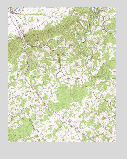
Sylvatus, VA USGS Topographic Map
Click on map above to begin viewing in our Map Viewer.

This topographic map contains these locations and features:
Feature Name Type Latitude Longitude GNIS ID View Map
Alexander CemeteryCemeteryN36.8523°W80.7934°1738581View Map
Alford CemeteryCemeteryN36.7910°W80.8692°1738583View Map
Allen CemeteryCemeteryN36.8215°W80.8081°1738585View Map
Beasley Hill CemeteryCemeteryN36.8018°W80.8234°1462916View Map
Coaltrain School (historical)SchoolN36.7629°W80.7873°1738635View Map
Colonel Ira B Coltrane Memorial BridgeBridgeN36.7860°W80.7576°1738640View Map
Corinth ChurchChurchN36.7912°W80.8704°1465252View Map
Corinth School (historical)SchoolN36.7862°W80.8673°1738642View Map
Coulson CemeteryCemeteryN36.7698°W80.8434°1738643View Map
Coulson ChurchChurchN36.7696°W80.8440°1465284View Map
Cranberry CreekStreamN36.7743°W80.7529°1465406View Map
Dalton Hill ChurchChurchN36.7912°W80.7723°1465574View Map
Dalton Hill School (historical)SchoolN36.7973°W80.7642°1738655View Map
EarlyPopulated PlaceN36.8073°W80.7901°1499369View Map
Five ForksPopulated PlaceN36.7637°W80.8004°1499417View Map
Handy CreekStreamN36.8426°W80.8556°1467703View Map
Interchange 19CrossingN36.7832°W80.8306°1738736View Map
Interchange 24CrossingN36.8496°W80.8612°1501319View Map
Jackson FerryLocaleN36.8710°W80.8665°1468600View Map
Jackson Memorial Elementary SchoolSchoolN36.8626°W80.8648°1468609View Map
Jackson Peak CemeteryCemeteryN36.8504°W80.7765°1738739View Map
Laurel BranchStreamN36.7762°W80.8645°1469158View Map
Laurel CreekStreamN36.8129°W80.8337°1469172View Map
Laurel Elementary SchoolSchoolN36.7970°W80.8517°1469198View Map
Laurel Rescue SquadBuildingN36.7974°W80.8505°2086322View Map
Liberty Grove Church (historical)ChurchN36.8612°W80.8534°1501338View Map
Lilburn Richardson CemeteryCemeteryN36.8279°W80.7706°1738774View Map
Little Vine CemeteryCemeteryN36.8351°W80.7723°1738776View Map
Little Vine ChurchChurchN36.8401°W80.7704°1469682View Map
Little Vine School (historical)SchoolN36.8332°W80.7698°1738777View Map
Mabe CemeteryCemeteryN36.7726°W80.8506°1738781View Map
Mill CreekStreamN36.8246°W80.7845°1470475View Map
Mitchell CemeteryCemeteryN36.7682°W80.8106°1738811View Map
Moccasin BranchStreamN36.8743°W80.7731°1470649View Map
Mount Tabor School (historical)SchoolN36.8115°W80.8090°1738824View Map
Mount Zion SchoolSchoolN36.7541°W80.8342°2727651View Map
Myers CemeteryCemeteryN36.8290°W80.8098°1738827View Map
Nebo School (historical)SchoolN36.7573°W80.8731°1738828View Map
New Castleton School (historical)SchoolN36.8676°W80.8142°1501350View Map
Ogle BranchStreamN36.8198°W80.7687°1471818View Map
Old Shop TowerLocaleN36.8701°W80.8698°1471875View Map
Osbourne CemeteryCemeteryN36.8648°W80.7656°1738849View Map
Parnell CemeteryCemeteryN36.8321°W80.8070°1738853View Map
Pickett CemeteryCemeteryN36.8090°W80.8648°1738857View Map
Pine Grove CemeteryCemeteryN36.8173°W80.8148°1738860View Map
Pine Grove ChurchChurchN36.8171°W80.8154°1472343View Map
Pleasant Grove ChurchChurchN36.8701°W80.7720°1472477View Map
Pleasant View ChurchChurchN36.8082°W80.8642°1472516View Map
Poplar CampLocaleN36.8498°W80.8626°1472636View Map
Poplar Camp MountainSummitN36.8518°W80.8267°1499894View Map
Porter BranchStreamN36.8365°W80.8570°1486361View Map
Quesenberry-Dalton CemeteryCemeteryN36.8551°W80.7653°1738867View Map
RackettownPopulated PlaceN36.8635°W80.8290°1472928View Map
RichardsonPopulated PlaceN36.8243°W80.7809°1499956View Map
Rock CreekStreamN36.8632°W80.7762°1473364View Map
Round KnobSummitN36.8396°W80.8026°1499995View Map
Round Knob CemeteryCemeteryN36.8232°W80.8187°1738880View Map
Round Knob ChurchChurchN36.8226°W80.8181°1473583View Map
Round Knob School (historical)SchoolN36.8415°W80.8048°1738881View Map
Shiloh CemeteryCemeteryN36.7648°W80.8017°1738893View Map
Shiloh ChurchChurchN36.7646°W80.8009°1474500View Map
Shockley School (historical)SchoolN36.7826°W80.7842°1738894View Map
Shorts CreekStreamN36.8710°W80.8676°1474562View Map
Shorts CreekPopulated PlaceN36.8387°W80.8459°1477749View Map
Shorts Creek Church of GodChurchN36.8362°W80.8262°1738895View Map
Shorts Creek-Frazier CemeteryCemeteryN36.8360°W80.8262°1738896View Map
Shot Tower State Historical ParkParkN36.8690°W80.8629°1474565View Map
Surratt CemeteryCemeteryN36.8373°W80.7537°1738914View Map
SylvatusPopulated PlaceN36.8585°W80.7637°1500203View Map
Sylvatus Elementary SchoolSchoolN36.8571°W80.7640°1738916View Map
Trout BranchStreamN36.7807°W80.7604°1475894View Map
Twin County AirportAirportN36.7644°W80.8221°1498678View Map
WildwoodLocaleN36.7844°W80.8261°2377049View Map
Wildwood School (historical)SchoolN36.7793°W80.8356°1738952View Map

Note: Coordinates in the location and feature list above are referenced to NAD83 datum.


Copyright (C) 2008-2025 Ryan Niemi / Sunset Dynamics ... All Rights Reserved