TopoQuest Logo
Do you find TopoQuest useful?
Help keep TopoQuest running and adding new maps/features by donating!
Bitcoin:  19c7KJd3qBynnjoSw5npx9KScwjBe4ifkT
Litecoin:  LXs6TkuXGGXo1vDsWCkWVdjQX94eUKd6ui
Home View Maps Find Maps Find Places Resources & Links


Lambsburg, Virginia Topographic Map

USGS Map Title: Lambsburg, VA
USGS Map MRC: 36080E7
DRG (GeoTIFF) Download: o36080e7.tif


Neighboring USGS Topographic Map Quads:


  Galax, VA  
36080F8
 

  Woodlawn, VA  
36080F7
 

  Fancy Gap, VA  
36080F6
 

  Cumberland Knob, NC  
36080E8
 

  Lambsburg, VA  
36080E7
 

  Cana, VA  
36080E6
 

  Roaring Gap, NC  
36080D8
 

  Bottom, NC  
36080D7
 

  Dobson, NC  
36080D6


Map MRC Location:

N37°
W81°
N37°
W80°
H8 H7 H6 H5 H4 H3 H2 H1
G8 G7 G6 G5 G4 G3 G2 G1
F8 F7 F6 F5 F4 F3 F2 F1
E8 E7 E6 E5 E4 E3 E2 E1
D8 D7 D6 D5 D4 D3 D2 D1
C8 C7 C6 C5 C4 C3 C2 C1
B8 B7 B6 B5 B4 B3 B2 B1
A8 A7 A6 A5 A4 A3 A2 A1
N36°
W81°
N36°
W80°

Lambsburg, VA USGS 1:24K Topographic Map Preview:
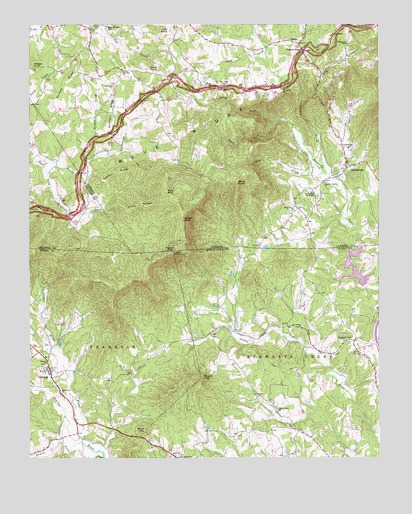
Lambsburg, VA USGS Topographic Map
Click on map above to begin viewing in our Map Viewer.

This topographic map contains these locations and features:
Feature Name Type Latitude Longitude GNIS ID View Map
Auberry CreekStreamN36.5340°W80.7998°1731517View Map
Blue Ridge ChapelChurchN36.6074°W80.8042°1463581View Map
Blue Ridge Chapel CemeteryCemeteryN36.6073°W80.8056°1738602View Map
Blue Ridge MillLocaleN36.6243°W80.8473°1463586View Map
Blue Ridge School (historical)SchoolN36.5707°W80.8656°1501157View Map
Blue Ridge School (historical)SchoolN36.6190°W80.7615°1738603View Map
Buck MountainSummitN36.5082°W80.8334°982112View Map
Camp BranchStreamN36.5018°W80.8490°1731543View Map
Chestnut Grove CemeteryCemeteryN36.5798°W80.7687°1738630View Map
Chestnut Grove ChurchChurchN36.5796°W80.7687°1464810View Map
Coleman CemeteryCemeteryN36.6115°W80.8415°1738636View Map
Coleman ChurchChurchN36.6118°W80.8409°1465084View Map
Coleman RidgeRidgeN36.6004°W80.8445°1465089View Map
Coleman School (historical)SchoolN36.6007°W80.8451°1738637View Map
Crooked OakPopulated PlaceN36.5340°W80.7587°983772View Map
Dicks KnobSummitN36.6124°W80.8312°1465784View Map
DrennPopulated PlaceN36.6196°W80.7781°1477275View Map
Edwards-Upchurch CemeteryCemeteryN36.5748°W80.7790°1738675View Map
Fairlawn CemeteryCemeteryN36.6076°W80.8451°1738683View Map
Fairlawn ChurchChurchN36.6079°W80.8448°1466396View Map
Fellowship TabernacleChurchN36.5768°W80.7728°1466526View Map
Fellowship Tabernacle CemeteryCemeteryN36.5768°W80.7734°1738686View Map
Felt KnobSummitN36.6235°W80.8240°1495534View Map
Fisher PeakSummitN36.5596°W80.8231°1020256View Map
Fishers Peak Historical SiteParkN36.5590°W80.8231°1001979View Map
Flat CreekStreamN36.5818°W80.7670°1466646View Map
Flint RidgeRidgeN36.5732°W80.8351°1466719View Map
Gully CreekStreamN36.5321°W80.8659°986204View Map
Hanks BranchStreamN36.5857°W80.8704°1467708View Map
Holly Grove ChurchChurchN36.5710°W80.7806°1468158View Map
Holly Grove School (historical)SchoolN36.5715°W80.7809°1738726View Map
Horse KnobSummitN36.5685°W80.8192°1468264View Map
Ivy Green Baptist ChurchChurchN36.5379°W80.7770°987453View Map
Ivy Green CemeteryCemeteryN36.5382°W80.7770°1731593View Map
LambsburgPopulated PlaceN36.5854°W80.7612°1495814View Map
Lambsburg Elementary SchoolSchoolN36.5893°W80.7601°1469114View Map
Lambsburg Post OfficePost OfficeN36.5885°W80.7619°2766235View Map
Lambsburg Rescue SquadBuildingN36.5798°W80.7702°2086321View Map
Lashley RidgeRidgeN36.5826°W80.8445°1469146View Map
Liberty ChurchChurchN36.5276°W80.8687°988423View Map
Linard CreekStreamN36.5874°W80.8512°1469436View Map
Low Gap Elementary SchoolSchoolN36.5293°W80.8684°1001987View Map
LowgapPopulated PlaceN36.5257°W80.8673°1000759View Map
Lowgap Census Designated PlaceCensusN36.5231°W80.8671°2628640View Map
Lowgap Post OfficePost OfficeN36.5228°W80.8672°2773803View Map
MaxLocaleN36.6074°W80.8106°1470202View Map
Mount Carroll CemeteryCemeteryN36.6068°W80.7837°1738819View Map
Mount Carroll ChurchChurchN36.6068°W80.7831°1470854View Map
Mount Vernon ChurchChurchN36.5004°W80.8215°990611View Map
Mount View ChurchChurchN36.5196°W80.8637°990619View Map
Mountain View Baptist ChurchChurchN36.5196°W80.8640°1731619View Map
North Fork Stewarts CreekStreamN36.5974°W80.7867°1471619View Map
Parish CemeteryCemeteryN36.5921°W80.8292°1738852View Map
Peter KingLocaleN36.5585°W80.8642°1001994View Map
Pipers GapLocaleN36.6174°W80.7765°1472429View Map
Ramey CreekStreamN36.5049°W80.8631°993010View Map
Rich MountainSummitN36.5768°W80.8251°1496145View Map
Roaring ForkStreamN36.5049°W80.8556°993430View Map
Round PeakPopulated PlaceN36.5135°W80.7865°1731651View Map
Round PeakSummitN36.5232°W80.8137°1022422View Map
Round Peak ChurchChurchN36.5146°W80.7862°993750View Map
Sams KnobSummitN36.5796°W80.7998°1496183View Map
Skull Camp Volunteer Fire Department Station 72ABuildingN36.5295°W80.8695°2639256View Map
South Fork Stewarts CreekStreamN36.5971°W80.7867°1474868View Map
Turkey CreekStreamN36.5832°W80.7692°1475939View Map
Wards GardenAreaN36.5807°W80.7962°1738942View Map
WBRF-FM (Galax)TowerN36.5596°W80.8234°1502644View Map
Wilson KnobSummitN36.6135°W80.8740°1496423View Map
Wolfpen RidgeRidgeN36.6082°W80.8615°1476915View Map
WPRH-FM (Galax)TowerN36.5596°W80.8231°1502643View Map
Zion Hill CemeteryCemeteryN36.5312°W80.7573°1731703View Map
Zion Hill Primitive Baptist ChurchChurchN36.5307°W80.7573°997806View Map
Zion Hill School (historical)SchoolN36.5332°W80.7506°1731704View Map

Note: Coordinates in the location and feature list above are referenced to NAD83 datum.


Copyright (C) 2008-2024 Ryan Niemi / Sunset Dynamics ... All Rights Reserved