TopoQuest Logo
Do you find TopoQuest useful?
Help keep TopoQuest running and adding new maps/features by donating!
Bitcoin:  19c7KJd3qBynnjoSw5npx9KScwjBe4ifkT
Litecoin:  LXs6TkuXGGXo1vDsWCkWVdjQX94eUKd6ui
Home View Maps Find Maps Find Places Resources & Links


Austinville, Virginia Topographic Map

USGS Map Title: Austinville, VA
USGS Map MRC: 36080G8
DRG (GeoTIFF) Download: o36080g8.tif


Neighboring USGS Topographic Map Quads:


  Wytheville, VA  
36081H1
 

  Max Meadows, VA  
36080H8
 

  Fosters Falls, VA  
36080H7
 

  Cripple Creek, VA  
36081G1
 

  Austinville, VA  
36080G8
 

  Sylvatus, VA  
36080G7
 

  Brierpatch Mountain, VA  
36081F1
 

  Galax, VA  
36080F8
 

  Woodlawn, VA  
36080F7


Map MRC Location:

N37°
W81°
N37°
W80°
H8 H7 H6 H5 H4 H3 H2 H1
G8 G7 G6 G5 G4 G3 G2 G1
F8 F7 F6 F5 F4 F3 F2 F1
E8 E7 E6 E5 E4 E3 E2 E1
D8 D7 D6 D5 D4 D3 D2 D1
C8 C7 C6 C5 C4 C3 C2 C1
B8 B7 B6 B5 B4 B3 B2 B1
A8 A7 A6 A5 A4 A3 A2 A1
N36°
W81°
N36°
W80°

Austinville, VA USGS 1:24K Topographic Map Preview:
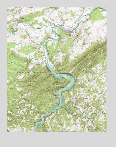
Austinville, VA USGS Topographic Map
Click on map above to begin viewing in our Map Viewer.

This topographic map contains these locations and features:
Feature Name Type Latitude Longitude GNIS ID View Map
Alley CemeteryCemeteryN36.7843°W80.9156°1738586View Map
AustinvillePopulated PlaceN36.8512°W80.9120°1481364View Map
Austinville Elementary School (historical)SchoolN36.8465°W80.9110°1501270View Map
Austinville Post OfficePost OfficeN36.8553°W80.9190°2780317View Map
Austinville QuarryMineN36.8436°W80.9250°2724886View Map
Bakers ChapelChurchN36.8626°W80.9854°1481419View Map
BethanyPopulated PlaceN36.8437°W80.8804°1492562View Map
Beulah ChurchChurchN36.8257°W80.9287°1481680View Map
Big BranchStreamN36.8093°W80.9429°1481700View Map
Bowers Ferry (historical)CrossingN36.7746°W80.9359°1738606View Map
Brown Hill ChurchChurchN36.8748°W80.9845°1482034View Map
Brush CreekStreamN36.7679°W80.9545°1482056View Map
BuckPopulated PlaceN36.8046°W80.9304°1492654View Map
Buck DamDamN36.8085°W80.9381°1488572View Map
Buck ReservoirReservoirN36.8085°W80.9381°1489400View Map
Buddle BranchStreamN36.8632°W80.9065°1482141View Map
Burnett-Hanks CemeteryCemeteryN36.7832°W80.9215°1738618View Map
Burnett-Oak Grove CemeteryCemeteryN36.7862°W80.9054°1738619View Map
ByllesbyPopulated PlaceN36.7846°W80.9351°1492688View Map
Byllesby DamDamN36.7851°W80.9331°1502179View Map
Byllesby ReservoirReservoirN36.7851°W80.9331°1489398View Map
Byllesby School (historical)SchoolN36.7962°W80.9240°1738620View Map
Chestnut CreekStreamN36.7587°W80.9554°1482469View Map
Chiswell HoleValleyN36.8443°W80.9335°1501282View Map
Cold RidgeRidgeN36.8032°W80.9704°1482619View Map
CorinthPopulated PlaceN36.7887°W80.8795°1482710View Map
Cripple CreekStreamN36.8562°W80.9392°1482837View Map
Crooked CreekStreamN36.7762°W80.9309°1482847View Map
Dean BranchStreamN36.8601°W80.9812°1482959View Map
Edwards ChapelChurchN36.7590°W80.9656°1483249View Map
Edwards Chapel CemeteryCemeteryN36.7587°W80.9654°1738674View Map
Fairview CemeteryCemeteryN36.8187°W80.9642°1738684View Map
Fairview ChurchChurchN36.8182°W80.9637°1483330View Map
Farmers MountainSummitN36.7915°W80.9506°1483379View Map
FlatwoodPopulated PlaceN36.8532°W80.8873°1483451View Map
Flatwood ShaftMineN36.8623°W80.8976°1483452View Map
Flatwoods Church of GodChurchN36.8507°W80.8854°1501300View Map
Forest ChurchChurchN36.8343°W80.9595°1483481View Map
Fossil PointSummitN36.8454°W80.9062°1501303View Map
Fowler Ferry (historical)CrossingN36.8015°W80.9179°1738693View Map
Frazier CemeteryCemeteryN36.8137°W80.8867°1738694View Map
Fries JunctionPopulated PlaceN36.7621°W80.9554°1492978View Map
Grays School (historical)SchoolN36.8246°W80.9295°1738709View Map
GraysonPopulated PlaceN36.7676°W80.9487°1493023View Map
Independent Order of Odd Fellows CemeteryCemeteryN36.8446°W80.9701°1484308View Map
IvanhoePopulated PlaceN36.8401°W80.9667°1484369View Map
Ivanhoe Census Designated PlaceCensusN36.8429°W80.9683°2628834View Map
Ivanhoe ShaftMineN36.8343°W80.9615°1484370View Map
Ivanhoe Volunteer Fire DepartmentBuildingN36.8429°W80.9695°2085843View Map
Joseph Bryant CemeteryCemeteryN36.7701°W80.8940°1738759View Map
King CemeteryCemeteryN36.8118°W80.8948°1738763View Map
Kings ChapelChurchN36.8440°W80.9690°1484608View Map
Little Brush CreekStreamN36.7754°W80.9623°1484874View Map
Little MountainSummitN36.8204°W80.9251°1493212View Map
Long Branch Picnic AreaParkN36.7771°W80.9901°1485050View Map
McGee School (historical)SchoolN36.8112°W80.8873°1738806View Map
Mill CreekStreamN36.8554°W80.9284°1485424View Map
Monarat ChurchChurchN36.8087°W80.8909°1485515View Map
Mount Carmel ChurchChurchN36.8240°W80.9717°1485576View Map
Mount Hope CemeteryCemeteryN36.7732°W80.9837°1738821View Map
Mount Olivet ChurchChurchN36.7840°W80.9162°1485616View Map
New Hope ChurchChurchN36.7732°W80.9840°1485843View Map
Newman CemeteryCemeteryN36.7521°W80.9273°1738831View Map
Oak GrovePopulated PlaceN36.7823°W80.9026°1493362View Map
Oak Grove CemeteryCemeteryN36.7837°W80.9029°1738841View Map
Oak Grove Christian ChurchChurchN36.7835°W80.9026°1738842View Map
Olive Branch ChurchChurchN36.8743°W80.9709°1485973View Map
Pierce MillPopulated PlaceN36.8535°W80.9879°1493423View Map
Poor BranchStreamN36.8018°W80.9159°1486337View Map
Porters CrossroadsPopulated PlaceN36.8646°W80.9823°1486371View Map
Powder Mill BranchStreamN36.8301°W80.9492°1486401View Map
RaketownPopulated PlaceN36.8201°W80.9592°1486491View Map
River Hill CemeteryCemeteryN36.7568°W80.9359°1738874View Map
River Hill Christian ChurchChurchN36.7571°W80.9356°1738875View Map
River Hill School (historical)SchoolN36.7548°W80.9298°1738876View Map
RiverhillPopulated PlaceN36.7568°W80.9340°1493490View Map
Rocky BranchStreamN36.7968°W80.9170°1486722View Map
Round TopSummitN36.7976°W80.9384°1486794View Map
Sharp CemeteryCemeteryN36.7876°W80.8820°1738890View Map
Sheep TownPopulated PlaceN36.8240°W80.9145°1493575View Map
Sheeptown Church of GodChurchN36.8226°W80.9206°1738891View Map
Short HillSummitN36.8248°W80.9401°1493589View Map
Staunton BranchStreamN36.7690°W80.9026°1487542View Map
Stoots BranchStreamN36.8129°W80.9004°1487644View Map
Sulphur Springs DistrictCivilN36.7697°W80.8914°1927531View Map
Thorn FerryPopulated PlaceN36.8587°W80.9290°1501375View Map
Trinity ChurchChurchN36.8493°W80.9167°1487985View Map
Van Mater ShaftMineN36.8468°W80.9190°1488105View Map
Wolf BranchStreamN36.8079°W80.8920°1488435View Map

Note: Coordinates in the location and feature list above are referenced to NAD83 datum.


Copyright (C) 2008-2024 Ryan Niemi / Sunset Dynamics ... All Rights Reserved