TopoQuest Logo
Do you find TopoQuest useful?
Help keep TopoQuest running and adding new maps/features by donating!
Bitcoin:  19c7KJd3qBynnjoSw5npx9KScwjBe4ifkT
Litecoin:  LXs6TkuXGGXo1vDsWCkWVdjQX94eUKd6ui
Home View Maps Find Maps Find Places Resources & Links


Galena, Missouri Topographic Map

USGS Map Title: Galena, MO
USGS Map MRC: 36093G4
DRG (GeoTIFF) Download: o36093g4.tif


Neighboring USGS Topographic Map Quads:


  Crane, MO  
36093H5
 

  Hurley, MO  
36093H4
 

  Highlandville, MO  
36093H3
 

  Elsey, MO  
36093G5
 

  Galena, MO  
36093G4
 

  Spokane, MO  
36093G3
 

  Cape Fair, MO  
36093F5
 

  Reeds Spring, MO  
36093F4
 

  Garber, MO  
36093F3


Map MRC Location:

N37°
W94°
N37°
W93°
H8 H7 H6 H5 H4 H3 H2 H1
G8 G7 G6 G5 G4 G3 G2 G1
F8 F7 F6 F5 F4 F3 F2 F1
E8 E7 E6 E5 E4 E3 E2 E1
D8 D7 D6 D5 D4 D3 D2 D1
C8 C7 C6 C5 C4 C3 C2 C1
B8 B7 B6 B5 B4 B3 B2 B1
A8 A7 A6 A5 A4 A3 A2 A1
N36°
W94°
N36°
W93°

Galena, MO USGS 1:24K Topographic Map Preview:
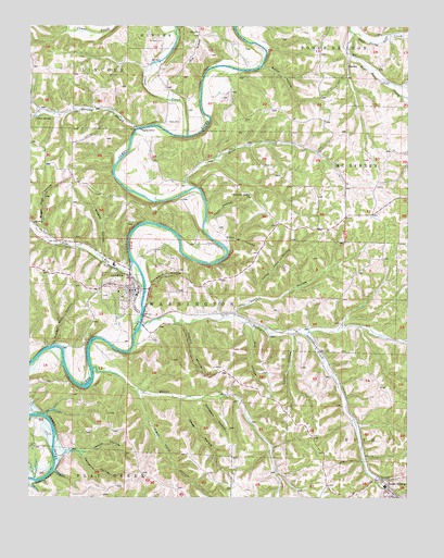
Galena, MO USGS Topographic Map
Click on map above to begin viewing in our Map Viewer.

This topographic map contains these locations and features:
Feature Name Type Latitude Longitude GNIS ID View Map
Arnold Lodge (historical)LocaleN36.7985°W93.4671°2646538View Map
Bass CemeteryCemeteryN36.8501°W93.4544°713718View Map
Bear Den Junction (historical)Populated PlaceN36.7531°W93.4021°2646543View Map
Bob HollowValleyN36.7953°W93.4269°714464View Map
Brushy HollowValleyN36.8156°W93.4766°714910View Map
Butler BluffsCliffN36.7931°W93.4665°2646759View Map
Butler HollowValleyN36.8645°W93.4232°715124View Map
Camp Clark (historical)LocaleN36.8182°W93.4679°2645949View Map
Camp Yocum (historical)LocaleN36.8259°W93.4431°2645947View Map
Canady Hill HollowValleyN36.8067°W93.4605°715331View Map
CaricoPopulated PlaceN36.7945°W93.4113°737926View Map
Carico HollowValleyN36.7934°W93.4135°715395View Map
Carr Ford (historical)LocaleN36.7726°W93.4952°2646542View Map
Cave SpringSpringN36.8506°W93.4982°715528View Map
Christian Union ChurchChurchN36.8298°W93.4271°715821View Map
City of GalenaCivilN36.8053°W93.4709°2394841View Map
Compton HollowValleyN36.7762°W93.4432°716162View Map
Coon HollowValleyN36.8245°W93.4413°716266View Map
Crane CreekStreamN36.8462°W93.4485°716462View Map
Cresent School (historical)SchoolN36.8723°W93.3943°2645932View Map
East Prong Goff CreekStreamN36.8739°W93.3944°717339View Map
Edgar Camp (historical)LocaleN36.8304°W93.4478°2645948View Map
GalenaPopulated PlaceN36.8053°W93.4666°735624View Map
Galena Post OfficePost OfficeN36.8102°W93.4675°2779512View Map
Gregg Camp (historical)LocaleN36.7887°W93.4913°2645952View Map
Hampton HollowValleyN36.7623°W93.4888°719052View Map
Hazel HollowValleyN36.7762°W93.4507°719297View Map
Horse CreekStreamN36.8326°W93.4460°719847View Map
Horse Creek School (historical)SchoolN36.8354°W93.4494°2645946View Map
Jessie HollowValleyN36.7623°W93.4835°720313View Map
John HollowValleyN36.7989°W93.4327°720340View Map
Limberlost Camp (historical)LocaleN36.8110°W93.4676°2645950View Map
Little John HollowValleyN36.8039°W93.4246°721258View Map
Muehlbach Camp (historical)LocaleN36.8483°W93.4653°2635928View Map
North Stone Northeast Barry County Fire District Station 21BuildingN36.8057°W93.4651°2620330View Map
OtoPopulated PlaceN36.8587°W93.4549°732909View Map
Oto ChurchChurchN36.8737°W93.4446°723871View Map
Oto School (historical)SchoolN36.8601°W93.4557°732911View Map
Parsons CemeteryCemeteryN36.8712°W93.4566°724060View Map
Pine RunStreamN36.8123°W93.4663°735781View Map
Populis HollowValleyN36.7962°W93.4496°724757View Map
Powder Mill HollowValleyN36.7903°W93.4927°724805View Map
Pratt HollowValleyN36.8164°W93.4349°724909View Map
Railey CreekStreamN36.7956°W93.4635°751800View Map
Railey Creek School (historical)SchoolN36.7953°W93.4105°732908View Map
Ramblers Camp (historical)LocaleN36.8056°W93.4745°2645951View Map
Reeds Spring Police DepartmentBuildingN36.7537°W93.3831°2752552View Map
Right Hand HollowValleyN36.7778°W93.4641°751875View Map
Stone County Sheriff's OfficeBuildingN36.8050°W93.4652°2752507View Map
Sugar Tree HollowValleyN36.8206°W93.4949°727250View Map
Taylor Camp (historical)LocaleN36.7814°W93.4846°2646541View Map
Township of McKinleyCivilN36.8382°W93.3873°767430View Map
Township of WashingtonCivilN36.8020°W93.4737°767439View Map
Watts-Smith Airport (historical)AirportN36.7989°W93.4224°758689View Map
West Prong Goff CreekStreamN36.8739°W93.3944°728617View Map
Wheeler BranchStreamN36.8481°W93.4646°728686View Map
Wilson RunStreamN36.7839°W93.4796°752929View Map

Note: Coordinates in the location and feature list above are referenced to NAD83 datum.


Copyright (C) 2008-2024 Ryan Niemi / Sunset Dynamics ... All Rights Reserved