TopoQuest Logo
Do you find TopoQuest useful?
Help keep TopoQuest running and adding new maps/features by donating!
Bitcoin:  19c7KJd3qBynnjoSw5npx9KScwjBe4ifkT
Litecoin:  LXs6TkuXGGXo1vDsWCkWVdjQX94eUKd6ui
Home View Maps Find Maps Find Places Resources & Links


Hurley, Missouri Topographic Map

USGS Map Title: Hurley, MO
USGS Map MRC: 36093H4
DRG (GeoTIFF) Download: o36093h4.tif


Neighboring USGS Topographic Map Quads:


  Billings, MO  
37093A5
 

  Republic, MO  
37093A4
 

  Nixa, MO  
37093A3
 

  Crane, MO  
36093H5
 

  Hurley, MO  
36093H4
 

  Highlandville, MO  
36093H3
 

  Elsey, MO  
36093G5
 

  Galena, MO  
36093G4
 

  Spokane, MO  
36093G3


Map MRC Location:

N37°
W94°
N37°
W93°
H8 H7 H6 H5 H4 H3 H2 H1
G8 G7 G6 G5 G4 G3 G2 G1
F8 F7 F6 F5 F4 F3 F2 F1
E8 E7 E6 E5 E4 E3 E2 E1
D8 D7 D6 D5 D4 D3 D2 D1
C8 C7 C6 C5 C4 C3 C2 C1
B8 B7 B6 B5 B4 B3 B2 B1
A8 A7 A6 A5 A4 A3 A2 A1
N36°
W94°
N36°
W93°

Hurley, MO USGS 1:24K Topographic Map Preview:
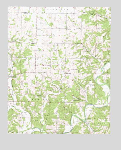
Hurley, MO USGS Topographic Map
Click on map above to begin viewing in our Map Viewer.

This topographic map contains these locations and features:
Feature Name Type Latitude Longitude GNIS ID View Map
Anderson CemeteryCemeteryN36.8764°W93.4780°713278View Map
Barnett SpringSpringN36.9664°W93.4952°713686View Map
Bland HollowValleyN36.9153°W93.4969°714355View Map
City of HurleyCivilN36.9306°W93.4995°2394456View Map
Clever Fire Protection District Station 3BuildingN36.9795°W93.4662°2620619View Map
Crossroads ChurchChurchN36.9642°W93.4669°716533View Map
Dry Crane CreekStreamN36.8759°W93.4577°717083View Map
Goff CreekStreamN36.8867°W93.4066°718540View Map
Hampton School (historical)SchoolN36.9417°W93.4216°732902View Map
Hayes SpringSpringN36.9195°W93.4363°719261View Map
Henry School (historical)SchoolN36.9278°W93.4582°732900View Map
High Ridge ChurchChurchN36.9231°W93.4005°719559View Map
Hooten HillSummitN36.9270°W93.4002°719782View Map
Hootentown BridgeBridgeN36.9392°W93.3857°755218View Map
Hootentown Natural ArchArchN36.9247°W93.3928°2680470View Map
HurleyPopulated PlaceN36.9314°W93.4991°735662View Map
Hurley Fire Protection DistrictBuildingN36.9307°W93.4962°2621213View Map
Hurley Post OfficePost OfficeN36.9308°W93.4968°2782707View Map
Inmon School (historical)SchoolN36.9203°W93.3994°732903View Map
Jumbo SpringSpringN36.9948°W93.4057°720457View Map
Lane BranchStreamN36.9092°W93.4541°720794View Map
Lane SpringSpringN36.9126°W93.4591°720798View Map
Lanetown HollowValleyN36.9473°W93.4932°720801View Map
Lanetown SpringSpringN36.9445°W93.4902°720802View Map
Little White ChurchChurchN36.9562°W93.3999°721359View Map
Long Tom HollowValleyN36.8826°W93.4560°721556View Map
McCall BridgeBridgeN36.9042°W93.3980°755308View Map
McCullah HollowValleyN36.9484°W93.4974°722072View Map
Old Stillhouse HollowValleyN36.9070°W93.4041°723789View Map
Old Stillhouse SpringSpringN36.9078°W93.4121°723790View Map
Oto RidgeRidgeN36.8867°W93.4396°723872View Map
Possum TrotPopulated PlaceN36.9787°W93.4291°741168View Map
Richmond School (historical)SchoolN36.9781°W93.3932°732901View Map
Sam Thomas Camp (historical)LocaleN36.8860°W93.4047°2635929View Map
SchoolPopulated PlaceN36.9651°W93.4674°740421View Map
Short CemeteryCemeteryN36.9181°W93.4974°726414View Map
Silver LakeLakeN36.9639°W93.4134°726450View Map
Silver Lake BranchStreamN36.9420°W93.3830°726454View Map
Smith Brown HollowValleyN36.9045°W93.4024°726581View Map
Spring CreekStreamN36.8987°W93.4874°726903View Map
Sugar Camp HollowValleyN36.8951°W93.4205°727216View Map
Township of CassCivilN36.9599°W93.3866°767424View Map
Township of HurleyCivilN36.9167°W93.4707°767428View Map
Township of UnionCivilN36.9729°W93.4720°767438View Map
Union CityPopulated PlaceN36.9789°W93.4657°728006View Map
Union Ridge ChurchChurchN36.9787°W93.4113°728031View Map
White CemeteryCemeteryN36.9573°W93.4435°728714View Map
White CityPopulated PlaceN36.8803°W93.3980°741356View Map
Wright CemeteryCemeteryN36.9617°W93.4685°729156View Map
Wright ChapelChurchN36.9353°W93.4291°729161View Map
Wright Chapel CemeteryCemeteryN36.9359°W93.4349°729162View Map

Note: Coordinates in the location and feature list above are referenced to NAD83 datum.


Copyright (C) 2008-2025 Ryan Niemi / Sunset Dynamics ... All Rights Reserved