TopoQuest Logo
Do you find TopoQuest useful?
Help keep TopoQuest running and adding new maps/features by donating!
Bitcoin:  19c7KJd3qBynnjoSw5npx9KScwjBe4ifkT
Litecoin:  LXs6TkuXGGXo1vDsWCkWVdjQX94eUKd6ui
Home View Maps Find Maps Find Places Resources & Links


Gallatin, Arkansas Topographic Map

USGS Map Title: Gallatin, AR
USGS Map MRC: 36094B4
DRG (GeoTIFF) Download: o36094b4.tif


Neighboring USGS Topographic Map Quads:


  Cherokee City, AR  
36094C5
 

  Gentry, AR  
36094C4
 

  Centerton, AR  
36094C3
 

  Siloam Springs, AR  
36094B5
 

  Gallatin, AR  
36094B4
 

  Robinson, AR  
36094B3
 

  Watts, OK  
36094A5
 

  Rhea, AR  
36094A4
 

  Wheeler, AR  
36094A3


Map MRC Location:

N37°
W95°
N37°
W94°
H8 H7 H6 H5 H4 H3 H2 H1
G8 G7 G6 G5 G4 G3 G2 G1
F8 F7 F6 F5 F4 F3 F2 F1
E8 E7 E6 E5 E4 E3 E2 E1
D8 D7 D6 D5 D4 D3 D2 D1
C8 C7 C6 C5 C4 C3 C2 C1
B8 B7 B6 B5 B4 B3 B2 B1
A8 A7 A6 A5 A4 A3 A2 A1
N36°
W95°
N36°
W94°

Gallatin, AR USGS 1:24K Topographic Map Preview:
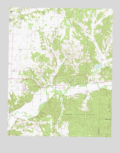
Gallatin, AR USGS Topographic Map
Click on map above to begin viewing in our Map Viewer.

This topographic map contains these locations and features:
Feature Name Type Latitude Longitude GNIS ID View Map
Belview School (historical)SchoolN36.2009°W94.4874°75380View Map
Camp OzarkLocaleN36.2381°W94.4858°70972View Map
Chambers HollowValleyN36.1659°W94.4358°76584View Map
Chambers Spring BranchStreamN36.1665°W94.4349°75428View Map
Davis CemeteryCemeteryN36.1265°W94.4772°71342View Map
FairmountPopulated PlaceN36.2267°W94.4460°75491View Map
Fairmount Baptist Church (historical)ChurchN36.2270°W94.4460°75492View Map
Fairmount CemeteryCemeteryN36.2276°W94.4449°71573View Map
Fairmount Community HallLocaleN36.2270°W94.4441°71574View Map
Fairmount School (historical)SchoolN36.2270°W94.4455°75493View Map
Felker (historical)Populated PlaceN36.2273°W94.4683°75501View Map
Fisher FordCrossingN36.1448°W94.4947°75512View Map
Fisher Ford BridgeBridgeN36.1448°W94.4947°75514View Map
Flint (historical)Populated PlaceN36.2237°W94.4683°75516View Map
Flint Creek CemeteryCemeteryN36.2426°W94.4997°71639View Map
Galey HollowValleyN36.2042°W94.3827°76993View Map
GallatinPopulated PlaceN36.2062°W94.4272°71713View Map
Gallatin Fire StationBuildingN36.2064°W94.4271°2116467View Map
Gum SpringsSpringN36.1701°W94.4769°77092View Map
Gum Springs Baptist ChurchChurchN36.1704°W94.4799°77094View Map
Gum Springs HollowValleyN36.1656°W94.4688°75540View Map
Illinois Valley School (historical)SchoolN36.1617°W94.4705°75564View Map
Lindsley PrairieFlatN36.2159°W94.4827°77502View Map
LoganPopulated PlaceN36.2009°W94.3874°72443View Map
Logan Cave National Wildlife RefugeParkN36.1980°W94.3957°2765376View Map
Logan CemeteryCemeteryN36.1990°W94.3877°75592View Map
Logan Church (historical)ChurchN36.2009°W94.3863°75593View Map
Logan Mill (historical)LocaleN36.1990°W94.3927°75594View Map
Logan School (historical)SchoolN36.2001°W94.3883°75595View Map
Logan SpringSpringN36.1976°W94.3930°72447View Map
Lone Elm (historical)Populated PlaceN36.2095°W94.4869°75598View Map
Lone Elm CemeteryCemeteryN36.2084°W94.4860°72453View Map
Lone Elm Church (historical)ChurchN36.2092°W94.4866°75599View Map
Lone Elm School (historical)SchoolN36.2098°W94.4866°75600View Map
Lower Round TopSummitN36.1617°W94.3780°75603View Map
MartinPopulated PlaceN36.1834°W94.4472°75900View Map
Martin CemeteryCemeteryN36.1845°W94.4463°72557View Map
Martin Community HallBuildingN36.1840°W94.4435°72558View Map
Martin School (historical)SchoolN36.1837°W94.4474°75902View Map
Martin ValleyValleyN36.1751°W94.4466°75903View Map
Mason School (historical)SchoolN36.1651°W94.4694°75904View Map
Mount Pleasant School (historical)SchoolN36.1654°W94.4244°75924View Map
Osage CreekStreamN36.1779°W94.4038°77925View Map
Ozark AcademySchoolN36.2387°W94.4997°72974View Map
Palmer HollowValleyN36.2056°W94.3855°72982View Map
PedroPopulated PlaceN36.1684°W94.4041°73034View Map
Pleasant Grove School (historical)SchoolN36.2309°W94.4766°75968View Map
Shady Grove Baptist ChurchChurchN36.2276°W94.4660°78327View Map
Shinn SpringSpringN36.1887°W94.4725°73549View Map
Smith FieldAirportN36.1892°W94.4917°83834View Map
Township 13CivilN36.1981°W94.4084°1989198View Map
Township of Ball (historical)CivilN36.1279°W94.4752°69573View Map
Township of Felker (historical)CivilN36.2251°W94.4530°69582View Map
Township of Logan (historical)CivilN36.2015°W94.3835°69589View Map
Township of Yell (historical)CivilN36.1626°W94.3835°69603View Map
Twin MountainsSummitN36.1523°W94.3794°73926View Map
Upper Round TopSummitN36.1462°W94.3783°76065View Map
Weddington Hiking TrailTrailN36.1287°W94.3919°74281View Map

Note: Coordinates in the location and feature list above are referenced to NAD83 datum.


Copyright (C) 2008-2025 Ryan Niemi / Sunset Dynamics ... All Rights Reserved