TopoQuest Logo
Do you find TopoQuest useful?
Help keep TopoQuest running and adding new maps/features by donating!
Bitcoin:  19c7KJd3qBynnjoSw5npx9KScwjBe4ifkT
Litecoin:  LXs6TkuXGGXo1vDsWCkWVdjQX94eUKd6ui
Home View Maps Find Maps Find Places Resources & Links


Garden Valley, California Topographic Map

USGS Map Title: Garden Valley, CA
USGS Map MRC: 38120G7
DRG (GeoTIFF) Download: o38120g7.tif


Neighboring USGS Topographic Map Quads:


  Greenwood, CA  
38120H8
 

  Georgetown, CA  
38120H7
 

  Tunnel Hill, CA  
38120H6
 

  Coloma, CA  
38120G8
 

  Garden Valley, CA  
38120G7
 

  Slate Mountain, CA  
38120G6
 

  Shingle Springs, CA  
38120F8
 

  Placerville, CA  
38120F7
 

  Camino, CA  
38120F6


Map MRC Location:

N39°
W121°
N39°
W120°
H8 H7 H6 H5 H4 H3 H2 H1
G8 G7 G6 G5 G4 G3 G2 G1
F8 F7 F6 F5 F4 F3 F2 F1
E8 E7 E6 E5 E4 E3 E2 E1
D8 D7 D6 D5 D4 D3 D2 D1
C8 C7 C6 C5 C4 C3 C2 C1
B8 B7 B6 B5 B4 B3 B2 B1
A8 A7 A6 A5 A4 A3 A2 A1
N38°
W121°
N38°
W120°

Garden Valley, CA USGS 1:24K Topographic Map Preview:
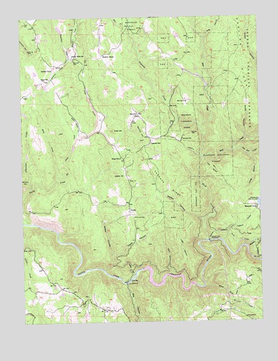
Garden Valley, CA USGS Topographic Map
Click on map above to begin viewing in our Map Viewer.

This topographic map contains these locations and features:
Feature Name Type Latitude Longitude GNIS ID View Map
Alhambra MineMineN38.8252°W120.7919°256182View Map
American FlatLocaleN38.8343°W120.8158°256219View Map
American River PowerhouseLocaleN38.7832°W120.7780°1654158View Map
Barley FlatFlatN38.8407°W120.7891°256530View Map
Bear CreekStreamN38.8166°W120.7813°256642View Map
Bear Creek Picnic AreaLocaleN38.8446°W120.7791°276199View Map
Big CanyonValleyN38.7657°W120.8219°219149View Map
Big Sailor CreekStreamN38.8080°W120.8585°257000View Map
Black Oak MineMineN38.8574°W120.8480°257146View Map
Chili BarPopulated PlaceN38.7671°W120.8216°258281View Map
Chili Bar ReservoirDamN38.7716°W120.8130°276200View Map
Creekside Elementary SchoolSchoolN38.8488°W120.8580°1733827View Map
Dark CanyonValleyN38.7693°W120.7991°259049View Map
Department of Forestry and Fire Protection Station 50 Garden ValleyBuildingN38.8495°W120.8618°2624032View Map
Divide High SchoolSchoolN38.8177°W120.8241°1733828View Map
Dubey AirportAirportN38.8442°W120.8315°1653481View Map
Empire CreekStreamN38.8577°W120.8513°259922View Map
Finnon Lake 1-034 DamDamN38.7971°W120.7522°1663238View Map
Finnon Lake CampgroundLocaleN38.7980°W120.7555°1662508View Map
Finnon Lake Picnic AreaLocaleN38.7977°W120.7533°1733831View Map
Finnon ReservoirReservoirN38.7982°W120.7506°260116View Map
Foster MountainSummitN38.8282°W120.8280°260286View Map
Garden ValleyPopulated PlaceN38.8541°W120.8594°1656039View Map
Garden Valley California Division of Forestry StationLocaleN38.8499°W120.8613°1733832View Map
Garden Valley Fire Protection District Station 51BuildingN38.8553°W120.8566°2624513View Map
Garden Valley Fire Protection District Station 52BuildingN38.7956°W120.8192°2624521View Map
Garden Valley Post OfficePost OfficeN38.8555°W120.8561°2780962View Map
Garden Valley SchoolSchoolN38.8588°W120.8494°260475View Map
Gold Hill NurseryLocaleN38.7646°W120.8663°1733834View Map
Gold Hill SchoolSchoolN38.7543°W120.8733°1662506View Map
Gold Trail Elementary SchoolSchoolN38.7532°W120.8719°1733836View Map
Gold Trail ParkPopulated PlaceN38.7527°W120.8499°1733837View Map
Golden Sierra High SchoolSchoolN38.8496°W120.8591°1733839View Map
Gopher HillSummitN38.8096°W120.8280°1656050View Map
Granite Hills VineyardsLocaleN38.7649°W120.7627°1733840View Map
Harricks RavineValleyN38.8252°W120.7583°261101View Map
Hog CanyonValleyN38.8657°W120.7799°261395View Map
Irish CreekStreamN38.8255°W120.8469°261804View Map
J W Marshall ShopLocaleN38.7935°W120.8188°1654286View Map
Jaybird CreekStreamN38.7827°W120.7713°261911View Map
Jodar Vineyard and WineryLocaleN38.7696°W120.7680°1733844View Map
KelseyPopulated PlaceN38.7988°W120.8208°262114View Map
Kelsey CanyonValleyN38.7710°W120.8335°262115View Map
Kelsey CemeteryCemeteryN38.7953°W120.8203°2755362View Map
Kelsey P OBuildingN38.8082°W120.8205°262118View Map
Kelsey SchoolSchoolN38.8174°W120.8244°262120View Map
KTLL-AM (Placerville)TowerN38.7549°W120.8652°1662692View Map
Ladies CanyonValleyN38.7688°W120.8183°262261View Map
Laumann RidgeRidgeN38.8043°W120.8013°262348View Map
Light CanyonValleyN38.7693°W120.7933°262443View Map
Little Sailor CreekStreamN38.8271°W120.8474°262710View Map
Long GulchValleyN38.8182°W120.7572°227565View Map
Manhattan CreekStreamN38.8580°W120.8513°263153View Map
Manhattan Creek 2461 DamDamN38.8699°W120.8560°1664371View Map
Meadow BrookPopulated PlaceN38.8593°W120.8341°1656157View Map
Mosquito CampLocaleN38.7968°W120.7527°263856View Map
Mosquito CreekStreamN38.7802°W120.7583°263862View Map
Mosquito TrailTrailN38.8160°W120.7791°263878View Map
Nancy Lee MineMineN38.8605°W120.8699°264000View Map
Negro HillSummitN38.7546°W120.7680°276203View Map
Nelson CanyonValleyN38.7907°W120.7813°264042View Map
North PlacervillePopulated PlaceN38.7549°W120.8316°1733859View Map
North Star Tree FarmLocaleN38.8616°W120.8260°1733860View Map
Oma 6 300 ReservoirReservoirN38.7716°W120.8127°1663682View Map
One Eye CreekStreamN38.8199°W120.7649°264356View Map
Rock CreekStreamN38.7832°W120.7794°265485View Map
Round HillSummitN38.8274°W120.7874°265596View Map
Slat CreekStreamN38.8716°W120.8191°266264View Map
Slate CreekStreamN38.8110°W120.8577°266267View Map
Slate MineMineN38.7655°W120.8202°266277View Map
Spanish FlatPopulated PlaceN38.8232°W120.8094°1656324View Map
Spanish HillSummitN38.8246°W120.8124°267551View Map
Taylor MineMineN38.8727°W120.8738°268108View Map
Teal PondReservoirN38.7525°W120.8353°1733876View Map
Texas CanyonValleyN38.7782°W120.8294°268161View Map
Trail GulchValleyN38.8166°W120.7813°268374View Map
Traverse CreekStreamN38.8299°W120.7830°268390View Map
Union HillSummitN38.7549°W120.7752°1662509View Map
Union SchoolSchoolN38.7513°W120.7597°268589View Map
White Rock CreekStreamN38.7643°W120.7810°269019View Map
White Rock Power HouseLocaleN38.7643°W120.7799°1662507View Map

Note: Coordinates in the location and feature list above are referenced to NAD83 datum.


Copyright (C) 2008-2024 Ryan Niemi / Sunset Dynamics ... All Rights Reserved