TopoQuest Logo
Do you find TopoQuest useful?
Help keep TopoQuest running and adding new maps/features by donating!
Bitcoin:  19c7KJd3qBynnjoSw5npx9KScwjBe4ifkT
Litecoin:  LXs6TkuXGGXo1vDsWCkWVdjQX94eUKd6ui
Home View Maps Find Maps Find Places Resources & Links


Georgetown, California Topographic Map

USGS Map Title: Georgetown, CA
USGS Map MRC: 38120H7
DRG (GeoTIFF) Download: o38120h7.tif


Neighboring USGS Topographic Map Quads:


  Colfax, CA  
39120A8
 

  Foresthill, CA  
39120A7
 

  Michigan Bluff, CA  
39120A6
 

  Greenwood, CA  
38120H8
 

  Georgetown, CA  
38120H7
 

  Tunnel Hill, CA  
38120H6
 

  Coloma, CA  
38120G8
 

  Garden Valley, CA  
38120G7
 

  Slate Mountain, CA  
38120G6


Map MRC Location:

N39°
W121°
N39°
W120°
H8 H7 H6 H5 H4 H3 H2 H1
G8 G7 G6 G5 G4 G3 G2 G1
F8 F7 F6 F5 F4 F3 F2 F1
E8 E7 E6 E5 E4 E3 E2 E1
D8 D7 D6 D5 D4 D3 D2 D1
C8 C7 C6 C5 C4 C3 C2 C1
B8 B7 B6 B5 B4 B3 B2 B1
A8 A7 A6 A5 A4 A3 A2 A1
N38°
W121°
N38°
W120°

Georgetown, CA USGS 1:24K Topographic Map Preview:
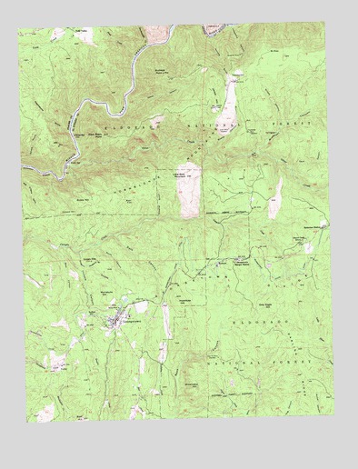
Georgetown, CA USGS Topographic Map
Click on map above to begin viewing in our Map Viewer.

This topographic map contains these locations and features:
Feature Name Type Latitude Longitude GNIS ID View Map
African BarLocaleN38.9655°W120.8549°256131View Map
Antwine GulchValleyN38.9391°W120.8219°256296View Map
Bald HillSummitN38.8760°W120.8530°256452View Map
Balderson StationPopulated PlaceN38.9346°W120.7541°1657988View Map
Bear FlatFlatN38.9452°W120.8349°256659View Map
Beebe MineMineN38.9105°W120.8380°256788View Map
Bottle HillSummitN38.9443°W120.8508°1658115View Map
BuckeyePopulated PlaceN38.9238°W120.7980°1658157View Map
Buckeye PointSummitN38.9835°W120.8160°257606View Map
Buffalo HillPopulated PlaceN38.9085°W120.8474°1658164View Map
Canyon Creek SchoolSchoolN38.9305°W120.7622°257952View Map
Cement HillSummitN38.9413°W120.8538°1658248View Map
Cock Robin PointSummitN38.9655°W120.8427°258501View Map
Cove Hill MineMineN38.8941°W120.7980°258792View Map
Dardanelles CreekStreamN38.9938°W120.8244°266618View Map
Dark CanyonValleyN38.9335°W120.8383°259050View Map
Dark CanyonValleyN38.9532°W120.7663°259051View Map
Darling RidgeRidgeN38.8768°W120.7605°259065View Map
Department of Forestry and Fire Protection Growlersburg Conservation CampBuildingN38.9040°W120.8694°2623986View Map
Divide Continuation High SchoolSchoolN38.9080°W120.8330°1733744View Map
Fords BarLocaleN38.9571°W120.8560°260247View Map
FornisPopulated PlaceN38.8924°W120.8613°260274View Map
Gas CanyonValleyN38.9063°W120.7949°274989View Map
GeorgetownPopulated PlaceN38.9068°W120.8385°1658606View Map
Georgetown AirportAirportN38.9194°W120.8641°1653480View Map
Georgetown Branch El Dorado County LibraryBuildingN38.9074°W120.8383°1733759View Map
Georgetown Census Designated PlaceCensusN38.9112°W120.8356°2408289View Map
Georgetown Control 460-002 DamDamN38.9232°W120.7758°1663897View Map
Georgetown DivideRidgeN38.9155°W120.7669°260529View Map
Georgetown Divide DitchCanalN38.9263°W120.8133°260530View Map
Georgetown Elementary SchoolSchoolN38.9082°W120.8333°1733760View Map
Georgetown Fire Department Station 61 HeadquartersBuildingN38.9067°W120.8390°2623817View Map
Georgetown Fire Department Station 62 BuckeyeBuildingN38.9228°W120.8027°2624149View Map
Georgetown Intermediate SchoolSchoolN38.9080°W120.8335°1733761View Map
Georgetown Post OfficePost OfficeN38.9071°W120.8370°1733762View Map
Georgetown Ranger StationLocaleN38.9249°W120.7897°260531View Map
Georgia SlideLocaleN38.9255°W120.8485°260532View Map
Green MineMineN38.9666°W120.7916°260857View Map
Grey Eagle HillSummitN38.9113°W120.7769°1658672View Map
Grizzly CanyonValleyN38.9671°W120.7702°260905View Map
Growlersburg State Conservation CampLocaleN38.8935°W120.8630°1733765View Map
Hotchkiss HillSummitN38.9135°W120.8149°261557View Map
Hudsons GulchValleyN38.9243°W120.8502°261594View Map
Illinois CanyonValleyN38.9302°W120.8585°261690View Map
Jakeys HillSummitN38.9738°W120.7972°261896View Map
Jesse CanyonValleyN38.9752°W120.8330°261934View Map
Josephine CanyonValleyN38.9996°W120.7899°226356View Map
Josephine MineMineN38.9902°W120.7866°262027View Map
Kanaka GulchValleyN38.9963°W120.7991°262073View Map
Kitts CanyonValleyN38.8960°W120.8127°274988View Map
Lake WaltonReservoirN38.9227°W120.7763°275038View Map
Lake Walton CampgroundLocaleN38.9252°W120.7835°274990View Map
Little Bald MountainSummitN38.9521°W120.8094°262508View Map
Mameluke HillSummitN38.9141°W120.8413°1659040View Map
Missouri CanyonValleyN38.9596°W120.7797°263704View Map
Mount HopeLocaleN38.9907°W120.7741°263889View Map
North CanyonValleyN38.9307°W120.8458°264122View Map
Oregon CanyonValleyN38.9285°W120.8535°264386View Map
Otter CreekStreamN38.9568°W120.8566°264414View Map
Paymaster MineMineN38.9655°W120.7841°264575View Map
Peachstone GulchValleyN38.9668°W120.8558°264586View Map
Pegleg CreekStreamN38.8760°W120.7874°264621View Map
Pond CreekStreamN38.9905°W120.8297°264919View Map
Quartz CanyonValleyN38.9607°W120.8005°265094View Map
Red DiggingsMineN38.9652°W120.7719°265265View Map
Rock CanyonValleyN38.8757°W120.8155°265472View Map
Shoemaker HillSummitN38.8843°W120.8060°1659652View Map
Todd ValleyPopulated PlaceN38.9980°W120.8516°1660009View Map
Volcano CanyonValleyN38.9999°W120.7891°268715View Map
VolcanovillePopulated PlaceN38.9818°W120.7891°268719View Map
West CanyonValleyN38.9299°W120.8622°268879View Map

Note: Coordinates in the location and feature list above are referenced to NAD83 datum.


Copyright (C) 2008-2025 Ryan Niemi / Sunset Dynamics ... All Rights Reserved