TopoQuest Logo
Do you find TopoQuest useful?
Help keep TopoQuest running and adding new maps/features by donating!
Bitcoin:  19c7KJd3qBynnjoSw5npx9KScwjBe4ifkT
Litecoin:  LXs6TkuXGGXo1vDsWCkWVdjQX94eUKd6ui
Home View Maps Find Maps Find Places Resources & Links


Camino, California Topographic Map

USGS Map Title: Camino, CA
USGS Map MRC: 38120F6
DRG (GeoTIFF) Download: o38120f6.tif


Neighboring USGS Topographic Map Quads:


  Garden Valley, CA  
38120G7
 

  Slate Mountain, CA  
38120G6
 

  Pollock Pines, CA  
38120G5
 

  Placerville, CA  
38120F7
 

  Camino, CA  
38120F6
 

  Sly Park, CA  
38120F5
 

  Fiddletown, CA  
38120E7
 

  Aukum, CA  
38120E6
 

  Omo Ranch, CA  
38120E5


Map MRC Location:

N39°
W121°
N39°
W120°
H8 H7 H6 H5 H4 H3 H2 H1
G8 G7 G6 G5 G4 G3 G2 G1
F8 F7 F6 F5 F4 F3 F2 F1
E8 E7 E6 E5 E4 E3 E2 E1
D8 D7 D6 D5 D4 D3 D2 D1
C8 C7 C6 C5 C4 C3 C2 C1
B8 B7 B6 B5 B4 B3 B2 B1
A8 A7 A6 A5 A4 A3 A2 A1
N38°
W121°
N38°
W120°

Camino, CA USGS 1:24K Topographic Map Preview:
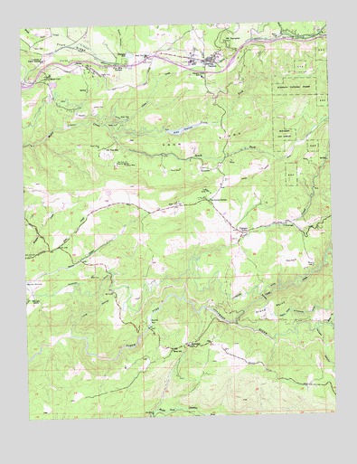
Camino, CA USGS Topographic Map
Click on map above to begin viewing in our Map Viewer.

This topographic map contains these locations and features:
Feature Name Type Latitude Longitude GNIS ID View Map
Abels Apple AcresLocaleN38.7466°W120.7485°1744672View Map
Avinsino CornerPopulated PlaceN38.6935°W120.6766°1657970View Map
Blair District SchoolSchoolN38.7396°W120.7008°257190View Map
Blakeley ReservoirReservoirN38.7406°W120.7067°257195View Map
Blakely 53-002 DamDamN38.7399°W120.7077°1663461View Map
Boca Vista OrchardsLocaleN38.7396°W120.7372°1744675View Map
Bucks BarBarN38.6552°W120.7008°257635View Map
Bucks Bar CampgroundLocaleN38.6532°W120.7022°1744676View Map
Butte CreekStreamN38.6532°W120.6288°257762View Map
California Department of Forestry and Fire Protection Station 20 Mount DanaherBuildingN38.7439°W120.6672°2623725View Map
CaminoPopulated PlaceN38.7382°W120.6749°1658198View Map
Camino Census Designated PlaceCensusN38.7412°W120.6816°2582961View Map
Camino Elementary SchoolSchoolN38.7329°W120.6766°257846View Map
Camino HeightsPopulated PlaceN38.7327°W120.7122°1744677View Map
Camino Post OfficePost OfficeN38.7379°W120.6743°1744678View Map
Camino SchoolSchoolN38.7405°W120.6713°1744679View Map
Camp CreekStreamN38.6552°W120.6666°257867View Map
Carson Ridge EvergreensLocaleN38.7416°W120.7299°1744680View Map
Cedar GrovePopulated PlaceN38.7446°W120.6569°1744683View Map
China CreekStreamN38.7185°W120.7177°258299View Map
Clear CreekStreamN38.6632°W120.6880°258429View Map
Crawford DitchCanalN38.6649°W120.6805°258897View Map
Cross Family VineyardsLocaleN38.7043°W120.6708°1744688View Map
Diamond Continuation High SchoolSchoolN38.7363°W120.7060°1744692View Map
Eight Mile HouseLocaleN38.7418°W120.6591°1662497View Map
Eight Mile House State Historic LandmarkParkN38.7418°W120.6591°1744697View Map
El Dorado County Fire Protection District Station 19BuildingN38.6865°W120.6672°2624519View Map
El Dorado County Fire Protection District Station 21BuildingN38.7382°W120.6777°2623671View Map
Eldorado National Forest Visitors CenterBuildingN38.7366°W120.7113°1744708View Map
Eldorado RanchLocaleN38.6632°W120.7474°259824View Map
Fay Gunby 1464-002 DamDamN38.7282°W120.7377°1664376View Map
Five Mile TerracePopulated PlaceN38.7382°W120.7130°1658543View Map
Fruit RidgeRidgeN38.7435°W120.7308°260434View Map
Gold Oak Elementary SchoolSchoolN38.6941°W120.7172°1744716View Map
Goldbud FarmsLocaleN38.7424°W120.7444°1744717View Map
Grand PointSummitN38.6588°W120.6519°1658644View Map
High Hill RanchLocaleN38.7393°W120.7097°1744725View Map
High Hill Ranch HeliportAirportN38.7418°W120.7185°1653312View Map
Institute of Forest GeneticsSchoolN38.7391°W120.7422°225952View Map
Jackass CanyonValleyN38.6530°W120.6335°261855View Map
Lava Cap WineryLocaleN38.7493°W120.7397°1744732View Map
Long RavineValleyN38.6513°W120.7333°262876View Map
Madrona VineyardsLocaleN38.7441°W120.7163°1744736View Map
Mills CreekStreamN38.6713°W120.7427°263649View Map
Mining Brook RanchLocaleN38.7171°W120.7122°1744741View Map
Motor CityPopulated PlaceN38.7338°W120.7405°263882View Map
Mount DanaherSummitN38.7443°W120.6688°1658373View Map
Mount Danaher Ranger Unit HeadquartersBuildingN38.7443°W120.6680°1744743View Map
New Weber DitchCanalN38.7257°W120.7372°264061View Map
NewtownPopulated PlaceN38.7043°W120.6791°1659223View Map
North Fork Weber CreekStreamN38.7146°W120.7144°264218View Map
Oak Hill CemeteryCemeteryN38.6768°W120.7491°264288View Map
Old Fort JimPopulated PlaceN38.7105°W120.7188°1659289View Map
Old Fort Jim Historical MarkerParkN38.7055°W120.7133°264325View Map
Old Jim MineMineN38.7116°W120.7202°1744744View Map
Perry CreekStreamN38.6263°W120.7002°264657View Map
Perryman AirportAirportN38.6960°W120.7326°1653827View Map
Pioneer Fire Protection District Station 32 Sand RidgeBuildingN38.6441°W120.6935°2624030View Map
Placerville District Office Eldorado National ForestBuildingN38.7374°W120.6635°1744755View Map
Placerville Ranger StationLocaleN38.7393°W120.7041°1662496View Map
Pleasant ValleyPopulated PlaceN38.6830°W120.6630°1659407View Map
Pleasant Valley SchoolSchoolN38.6832°W120.6644°1744759View Map
Rancho del SolPopulated PlaceN38.7202°W120.6527°1744761View Map
River SchoolSchoolN38.6457°W120.6922°265437View Map
Santas AcresLocaleN38.7427°W120.6922°1744763View Map
Seventh Day Adventist Community Service CenterBuildingN38.7399°W120.6994°1744765View Map
Sierra Vista WineryLocaleN38.6893°W120.6769°1744769View Map
Snow RidgeRidgeN38.7127°W120.6827°267328View Map
SomersetPopulated PlaceN38.6477°W120.6858°267389View Map
Somerset Post OfficePost OfficeN38.6474°W120.6846°1744777View Map
South Fork Weber CreekStreamN38.7146°W120.7144°267516View Map
Squaw HollowValleyN38.6685°W120.7444°267630View Map
Summerfield Berry FarmLocaleN38.7449°W120.6608°1744779View Map
The Big Apple OrchardLocaleN38.7457°W120.6524°1744781View Map
The Fruit Tree OrchardLocaleN38.7452°W120.6435°1744783View Map
Wakeley Special Education CenterSchoolN38.7332°W120.6774°1744787View Map
Webber 53-000 DamDamN38.7166°W120.6910°1663460View Map
Weber ReservoirReservoirN38.7163°W120.6863°268835View Map

Note: Coordinates in the location and feature list above are referenced to NAD83 datum.


Copyright (C) 2008-2025 Ryan Niemi / Sunset Dynamics ... All Rights Reserved