TopoQuest Logo
Do you find TopoQuest useful?
Help keep TopoQuest running and adding new maps/features by donating!
Bitcoin:  19c7KJd3qBynnjoSw5npx9KScwjBe4ifkT
Litecoin:  LXs6TkuXGGXo1vDsWCkWVdjQX94eUKd6ui
Home View Maps Find Maps Find Places Resources & Links


Garland, Maine Topographic Map

USGS Map Title: Garland, ME
USGS Map MRC: 45069A2
DRG (GeoTIFF) Download: o45069a2.tif


Neighboring USGS Topographic Map Quads:


  Sangerville, ME  
45069B3
 

  Dover-Foxcroft, ME  
45069B2
 

  South Sebec, ME  
45069B1
 

  Dexter, ME  
45069A3
 

  Garland, ME  
45069A2
 

  Charleston, ME  
45069A1
 

  Corinna, ME  
44069H3
 

  Stetson, ME  
44069H2
 

  West Corinth, ME  
44069H1


Map MRC Location:

N46°
W70°
N46°
W69°
H8 H7 H6 H5 H4 H3 H2 H1
G8 G7 G6 G5 G4 G3 G2 G1
F8 F7 F6 F5 F4 F3 F2 F1
E8 E7 E6 E5 E4 E3 E2 E1
D8 D7 D6 D5 D4 D3 D2 D1
C8 C7 C6 C5 C4 C3 C2 C1
B8 B7 B6 B5 B4 B3 B2 B1
A8 A7 A6 A5 A4 A3 A2 A1
N45°
W70°
N45°
W69°

Garland, ME USGS 1:24K Topographic Map Preview:
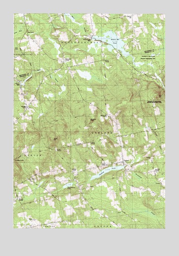
Garland, ME USGS Topographic Map
Click on map above to begin viewing in our Map Viewer.

This topographic map contains these locations and features:
Feature Name Type Latitude Longitude GNIS ID View Map
Berrys CornerPopulated PlaceN45.0981°W69.1767°579133View Map
Branns Mill PondReservoirN45.1086°W69.1676°562913View Map
Branns Pond DamDamN45.1118°W69.1850°1773815View Map
Bud Leavitt Wildlife Management AreaParkN45.0834°W69.1287°1913819View Map
Burnham CemeteryCemeteryN45.0441°W69.1265°2726967View Map
Burnham SchoolSchoolN45.0440°W69.1267°563222View Map
Carr CornerPopulated PlaceN45.0284°W69.2370°579176View Map
Center SchoolSchoolN45.0565°W69.1409°563770View Map
Coolidge CornerPopulated PlaceN45.0401°W69.2481°579211View Map
Dexter Regional AirportAirportN45.0014°W69.2345°582139View Map
Dover South MillsPopulated PlaceN45.1103°W69.1867°579253View Map
Durbin CornerPopulated PlaceN45.0498°W69.1864°579261View Map
Earnest CornerPopulated PlaceN45.0328°W69.1348°579266View Map
Evergreen CemeteryCemeteryN45.0410°W69.1360°2736913View Map
GarlandPopulated PlaceN45.0384°W69.1603°566708View Map
Garland Elementary SchoolSchoolN45.0345°W69.1555°2738066View Map
Garland PondReservoirN45.0332°W69.1729°566711View Map
Garland Pond DamDamN45.0350°W69.1587°1773787View Map
Garland Post OfficePost OfficeN45.0390°W69.1592°1913541View Map
Garland Volunteer Fire StationBuildingN45.0389°W69.1608°2552724View Map
Gordon CornerPopulated PlaceN45.0331°W69.2012°579348View Map
Greeley CemeteryCemeteryN45.0464°W69.1857°2736916View Map
Haseltine CornerPopulated PlaceN45.0701°W69.2378°579390View Map
Haseltine SchoolSchoolN45.0628°W69.2467°567729View Map
High CutSummitN45.0769°W69.1314°568010View Map
Knight CornerPopulated PlaceN45.0365°W69.1728°579454View Map
Macomber SchoolSchoolN45.0970°W69.2089°570634View Map
Mansfield LedgeBenchN45.0620°W69.1878°570713View Map
Maplewood CemeteryCemeteryN45.0366°W69.1727°2736926View Map
Norton HillSummitN45.1240°W69.1513°1910139View Map
Oliver Hill CornerPopulated PlaceN45.0659°W69.1728°579589View Map
Pine Grove CemeteryCemeteryN45.1083°W69.1764°2727316View Map
Preble CornerPopulated PlaceN45.0456°W69.2137°579638View Map
Preble HillSummitN45.0520°W69.2180°573772View Map
Russell CornerPopulated PlaceN45.0176°W69.2456°1913849View Map
Silvers MillsPopulated PlaceN45.0851°W69.2445°575471View Map
South Ridge SchoolSchoolN45.0006°W69.2342°575898View Map
Town of GarlandCivilN45.0543°W69.1586°582488View Map
West DoverPopulated PlaceN45.1145°W69.2389°579815View Map
West Garland CemeteryCemeteryN45.0307°W69.1995°2736942View Map
West Garland PondLakeN45.0252°W69.2046°578143View Map
West Garland SchoolSchoolN45.0287°W69.1989°578144View Map
WGUY-FM (Dexter)TowerN45.0445°W69.2499°582291View Map
WQCB-FM (Brewer)TowerN45.0573°W69.1903°582287View Map

Note: Coordinates in the location and feature list above are referenced to NAD83 datum.


Copyright (C) 2008-2025 Ryan Niemi / Sunset Dynamics ... All Rights Reserved