TopoQuest Logo
Do you find TopoQuest useful?
Help keep TopoQuest running and adding new maps/features by donating!
Bitcoin:  19c7KJd3qBynnjoSw5npx9KScwjBe4ifkT
Litecoin:  LXs6TkuXGGXo1vDsWCkWVdjQX94eUKd6ui
Home View Maps Find Maps Find Places Resources & Links


Stetson, Maine Topographic Map

USGS Map Title: Stetson, ME
USGS Map MRC: 44069H2
DRG (GeoTIFF) Download: o44069h2.tif


Neighboring USGS Topographic Map Quads:


  Dexter, ME  
45069A3
 

  Garland, ME  
45069A2
 

  Charleston, ME  
45069A1
 

  Corinna, ME  
44069H3
 

  Stetson, ME  
44069H2
 

  West Corinth, ME  
44069H1
 

  Newport, ME  
44069G3
 

  Plymouth, ME  
44069G2
 

  Carmel, ME  
44069G1


Map MRC Location:

N45°
W70°
N45°
W69°
H8 H7 H6 H5 H4 H3 H2 H1
G8 G7 G6 G5 G4 G3 G2 G1
F8 F7 F6 F5 F4 F3 F2 F1
E8 E7 E6 E5 E4 E3 E2 E1
D8 D7 D6 D5 D4 D3 D2 D1
C8 C7 C6 C5 C4 C3 C2 C1
B8 B7 B6 B5 B4 B3 B2 B1
A8 A7 A6 A5 A4 A3 A2 A1
N44°
W70°
N44°
W69°

Stetson, ME USGS 1:24K Topographic Map Preview:
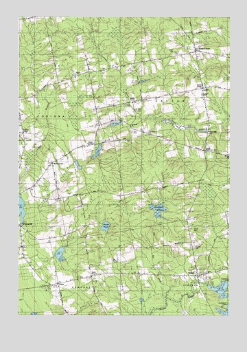
Stetson, ME USGS Topographic Map
Click on map above to begin viewing in our Map Viewer.

This topographic map contains these locations and features:
Feature Name Type Latitude Longitude GNIS ID View Map
Alder StreamReservoirN44.9194°W69.2481°1774114View Map
Archers DamDamN44.8876°W69.1379°1774247View Map
Bonds CornersLocaleN44.9467°W69.2042°562726View Map
Bragg HillSummitN44.9417°W69.1250°1913357View Map
Brooks PondLakeN44.9122°W69.1983°563017View Map
Chamberlain CemeteryCemeteryN44.9514°W69.1731°563801View Map
Cider HillBuildingN44.9862°W69.1545°1913409View Map
Clark HillSummitN44.9096°W69.1470°1913411View Map
Clark Hill CemeteryCemeteryN44.9035°W69.1462°564090View Map
CoburnPopulated PlaceN44.8881°W69.2253°579204View Map
Corinna CenterPopulated PlaceN44.9515°W69.2467°579214View Map
Corinna Center CemeteryCemeteryN44.9561°W69.2487°2736910View Map
Crossroads ChurchChurchN44.9548°W69.1834°563802View Map
Crowell CemeteryCemeteryN44.9842°W69.1560°564617View Map
Exeter CenterPopulated PlaceN44.9701°W69.1400°579304View Map
Exeter ChurchChurchN44.9678°W69.1398°1913508View Map
Exeter Consolidated SchoolSchoolN44.9696°W69.1404°1913509View Map
Exeter CornersPopulated PlaceN44.9848°W69.1453°565979View Map
Exeter Post OfficePost OfficeN44.9693°W69.1413°2768979View Map
First Baptist ChurchChurchN44.8928°W69.1384°1913521View Map
Footman BrookStreamN44.9570°W69.1764°566369View Map
French MillPopulated PlaceN44.9517°W69.1362°579324View Map
French StreamReservoirN44.9528°W69.1385°1774266View Map
French Stream DamDamN44.9528°W69.1385°1774265View Map
Greenbush SwampSwampN44.9190°W69.1662°567268View Map
Morse CornersLocaleN44.9384°W69.2292°571698View Map
Morses Corner CemeteryCemeteryN44.9405°W69.2245°2736929View Map
Nason DamDamN44.9129°W69.2490°1774113View Map
North NewportPopulated PlaceN44.8915°W69.2064°579570View Map
Pleasant LakeReservoirN44.8876°W69.1379°1774248View Map
South ExeterPopulated PlaceN44.9440°W69.1384°579716View Map
Spragues MillPopulated PlaceN44.9120°W69.2484°576083View Map
StetsonPopulated PlaceN44.8917°W69.1428°576301View Map
Stetson Post OfficePost OfficeN44.8920°W69.1442°2768965View Map
Stetson Public LibraryBuildingN44.8931°W69.1370°2738461View Map
Stetson Volunteer Fire DepartmentBuildingN44.8931°W69.1371°2552983View Map
Stubbs CornerPopulated PlaceN44.9642°W69.1814°579749View Map
Town of ExeterCivilN44.9644°W69.1355°582470View Map
Union ChurchChurchN44.8928°W69.1384°1913942View Map
White CemeteryCemeteryN44.9756°W69.2142°578347View Map

Note: Coordinates in the location and feature list above are referenced to NAD83 datum.


Copyright (C) 2008-2024 Ryan Niemi / Sunset Dynamics ... All Rights Reserved