TopoQuest Logo
Do you find TopoQuest useful?
Help keep TopoQuest running and adding new maps/features by donating!
Bitcoin:  19c7KJd3qBynnjoSw5npx9KScwjBe4ifkT
Litecoin:  LXs6TkuXGGXo1vDsWCkWVdjQX94eUKd6ui
Home View Maps Find Maps Find Places Resources & Links


Garner, North Carolina Topographic Map

USGS Map Title: Garner, NC
USGS Map MRC: 35078F5
DRG (GeoTIFF) Download: o35078f5.tif


Neighboring USGS Topographic Map Quads:


  Raleigh West, NC  
35078G6
 

  Raleigh East, NC  
35078G5
 

  Knightdale, NC  
35078G4
 

  Lake Wheeler, NC  
35078F6
 

  Garner, NC  
35078F5
 

  Clayton, NC  
35078F4
 

  Angier, NC  
35078E6
 

  Edmondson, NC  
35078E5
 

  Powhatan, NC  
35078E4


Map MRC Location:

N36°
W79°
N36°
W78°
H8 H7 H6 H5 H4 H3 H2 H1
G8 G7 G6 G5 G4 G3 G2 G1
F8 F7 F6 F5 F4 F3 F2 F1
E8 E7 E6 E5 E4 E3 E2 E1
D8 D7 D6 D5 D4 D3 D2 D1
C8 C7 C6 C5 C4 C3 C2 C1
B8 B7 B6 B5 B4 B3 B2 B1
A8 A7 A6 A5 A4 A3 A2 A1
N35°
W79°
N35°
W78°

Garner, NC USGS 1:24K Topographic Map Preview:
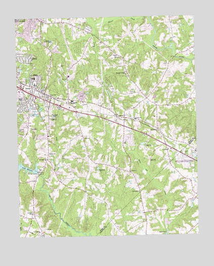
Garner, NC USGS Topographic Map
Click on map above to begin viewing in our Map Viewer.

This topographic map contains these locations and features:
Feature Name Type Latitude Longitude GNIS ID View Map
AuburnPopulated PlaceN35.6932°W78.5553°980364View Map
Aversboro Elementary SchoolSchoolN35.6890°W78.6161°1002911View Map
Bagwell AirportAirportN35.6752°W78.6098°2679180View Map
Bagwell CemeteryCemeteryN35.7280°W78.5539°980423View Map
Bagwell PondReservoirN35.7085°W78.5614°999277View Map
Bagwell Pond DamDamN35.7085°W78.5614°999276View Map
BainbridgePopulated PlaceN35.6904°W78.5992°1002901View Map
Bethel Church (historical)ChurchN35.6704°W78.6047°1951360View Map
Big BranchStreamN35.7468°W78.5675°981343View Map
Carolina Biblical GardensCemeteryN35.7357°W78.6042°982657View Map
CloverdalePopulated PlaceN35.7282°W78.6194°1019706View Map
Creech Road Elementary SchoolSchoolN35.7150°W78.6008°2455272View Map
Dunhaven by the LakePopulated PlaceN35.6668°W78.6192°1002907View Map
Eagle Crest Golf Course DamDamN35.7202°W78.5797°999304View Map
East Garner Middle SchoolSchoolN35.7019°W78.5858°2454660View Map
Ebenezer ChurchChurchN35.7271°W78.5519°984601View Map
Emerald VillagePopulated PlaceN35.7190°W78.5478°1020149View Map
First Congregational ChurchChurchN35.7451°W78.6073°2454729View Map
Forest HillsPopulated PlaceN35.7040°W78.6186°985274View Map
Forest LandingPopulated PlaceN35.6829°W78.5997°1002903View Map
GarnerPopulated PlaceN35.7113°W78.6142°985572View Map
Garner Consolidated SchoolSchoolN35.7027°W78.5867°985573View Map
Garner Elementary SchoolSchoolN35.7121°W78.6122°1002908View Map
Garner Mobile EstatesPopulated PlaceN35.6549°W78.6045°1002899View Map
Garner Police DepartmentBuildingN35.7056°W78.6201°2769647View Map
Garner Post OfficePost OfficeN35.6855°W78.6067°2455247View Map
Garner QuarryMineN35.7050°W78.5753°2649038View Map
Garner Volunteer Fire Department Station 1 HeadquartersBuildingN35.7095°W78.6133°2638866View Map
Gethsemane Seventh Day Adventist Day Care CenterBuildingN35.7449°W78.6138°2454202View Map
Good Samaritan ChurchChurchN35.6504°W78.5397°985795View Map
Hayes ChapelChurchN35.7065°W78.6014°986542View Map
Heather HillsPopulated PlaceN35.6990°W78.6219°1002905View Map
HeatheridgePopulated PlaceN35.6890°W78.6200°1002906View Map
HillandalePopulated PlaceN35.6885°W78.5889°1002900View Map
Hilliard CemeteryCemeteryN35.7224°W78.5939°1000912View Map
Immanuel Apostolic Church of ChristChurchN35.7258°W78.5619°2454811View Map
Interchange 303CrossingN35.7223°W78.5842°2455152View Map
Interchange 306ACrossingN35.6987°W78.5792°2455153View Map
Interchange 306BCrossingN35.6929°W78.5678°2455154View Map
Kingdom Hall of Jehovah's WitnessesChurchN35.7385°W78.5498°2454827View Map
Lake Benson DamDamN35.6618°W78.6114°999213View Map
Lake JohnsonReservoirN35.7497°W78.6207°999376View Map
Legend HillsPopulated PlaceN35.6704°W78.5500°1002896View Map
Mahlers CreekStreamN35.6585°W78.6070°989238View Map
Malibu ValleyPopulated PlaceN35.6877°W78.6064°1002902View Map
Meadowbrook Country ClubLocaleN35.6627°W78.5686°989682View Map
Mitchiner CemeteryCemeteryN35.6729°W78.6031°990105View Map
Mount Auburn SchoolSchoolN35.6918°W78.5425°990313View Map
Mount Calvary Holy ChurchChurchN35.7368°W78.6100°2454868View Map
Mount Herman ChurchChurchN35.6618°W78.5472°990398View Map
Mount Moriah ChurchChurchN35.6854°W78.5275°990443View Map
Mount Pleasant ChurchChurchN35.6740°W78.5197°990539View Map
Neal BranchStreamN35.6518°W78.6092°1951542View Map
New Bethel ChurchChurchN35.6693°W78.6053°990934View Map
North Carolina State University Central Research StationSchoolN35.6668°W78.5089°1000913View Map
North Garner Intermediate SchoolSchoolN35.7154°W78.6122°1002909View Map
Peacock AirportAirportN35.6979°W78.5368°2679181View Map
Penny PondReservoirN35.7168°W78.5564°999297View Map
Penny Pond DamDamN35.7168°W78.5564°999298View Map
Pine Hurst ParkPopulated PlaceN35.6929°W78.6006°1021908View Map
Progressive Missionary Baptist ChurchChurchN35.7444°W78.6073°2454940View Map
Raleigh Fire Department Station 10BuildingN35.7417°W78.6131°2454429View Map
Raleigh Fire Department Station 26BuildingN35.7323°W78.5548°2454437View Map
Rand CemeteryCemeteryN35.6632°W78.6083°993025View Map
Sauls CemeteryCemeteryN35.6387°W78.6159°994368View Map
School AcresPopulated PlaceN35.7163°W78.6092°1002910View Map
Smith CemeteryCemeteryN35.7071°W78.5417°994948View Map
Solid Rock Baptist ChurchChurchN35.7261°W78.5615°2455012View Map
Southeast Raleigh High SchoolSchoolN35.7458°W78.6040°2454686View Map
Springfield Baptist ChurchChurchN35.6972°W78.5443°2455018View Map
Town of GarnerCivilN35.6947°W78.6212°2406547View Map
Township of Saint MarysCivilN35.6994°W78.5773°1027273View Map
Truevine Apostolic Temple InternationalChurchN35.7395°W78.6171°2455048View Map
Turner CemeteryCemeteryN35.6295°W78.6069°996357View Map
Turner Memorial ChurchChurchN35.6277°W78.6103°996363View Map
Upper Room Church of God in ChristChurchN35.7367°W78.6165°2455060View Map
Van Story HillsPopulated PlaceN35.6821°W78.6061°1002904View Map
Village of White OakPopulated PlaceN35.6632°W78.5619°1002897View Map
White OakPopulated PlaceN35.6660°W78.5764°1002898View Map
WHPY-AM (Clayton)TowerN35.6471°W78.5056°1018473View Map
Wilson CemeteryCemeteryN35.6810°W78.5786°997437View Map
WKBQ-AM (Garner)TowerN35.7307°W78.6031°1018488View Map
Word of God Christian Day Care CenterBuildingN35.7471°W78.5992°2454524View Map
Word of God Fellowship ChurchChurchN35.7471°W78.5992°2455084View Map
WRAL-FM (Raleigh)TowerN35.6765°W78.5356°1018289View Map
WRAL-TV (Raleigh)TowerN35.6765°W78.5356°1018595View Map
WTVD-TV (Durham)TowerN35.6682°W78.5325°1018594View Map
Young Missionary TempleChurchN35.7394°W78.6116°2455088View Map
Young Missionary Temple Day Care and Learning CenterBuildingN35.7394°W78.6116°2454525View Map

Note: Coordinates in the location and feature list above are referenced to NAD83 datum.


Copyright (C) 2008-2025 Ryan Niemi / Sunset Dynamics ... All Rights Reserved