TopoQuest Logo
Do you find TopoQuest useful?
Help keep TopoQuest running and adding new maps/features by donating!
Bitcoin:  19c7KJd3qBynnjoSw5npx9KScwjBe4ifkT
Litecoin:  LXs6TkuXGGXo1vDsWCkWVdjQX94eUKd6ui
Home View Maps Find Maps Find Places Resources & Links


Clayton, North Carolina Topographic Map

USGS Map Title: Clayton, NC
USGS Map MRC: 35078F4
DRG (GeoTIFF) Download: o35078f4.tif


Neighboring USGS Topographic Map Quads:


  Raleigh East, NC  
35078G5
 

  Knightdale, NC  
35078G4
 

  Zebulon, NC  
35078G3
 

  Garner, NC  
35078F5
 

  Clayton, NC  
35078F4
 

  Flowers, NC  
35078F3
 

  Edmondson, NC  
35078E5
 

  Powhatan, NC  
35078E4
 

  Selma, NC  
35078E3


Map MRC Location:

N36°
W79°
N36°
W78°
H8 H7 H6 H5 H4 H3 H2 H1
G8 G7 G6 G5 G4 G3 G2 G1
F8 F7 F6 F5 F4 F3 F2 F1
E8 E7 E6 E5 E4 E3 E2 E1
D8 D7 D6 D5 D4 D3 D2 D1
C8 C7 C6 C5 C4 C3 C2 C1
B8 B7 B6 B5 B4 B3 B2 B1
A8 A7 A6 A5 A4 A3 A2 A1
N35°
W79°
N35°
W78°

Clayton, NC USGS 1:24K Topographic Map Preview:
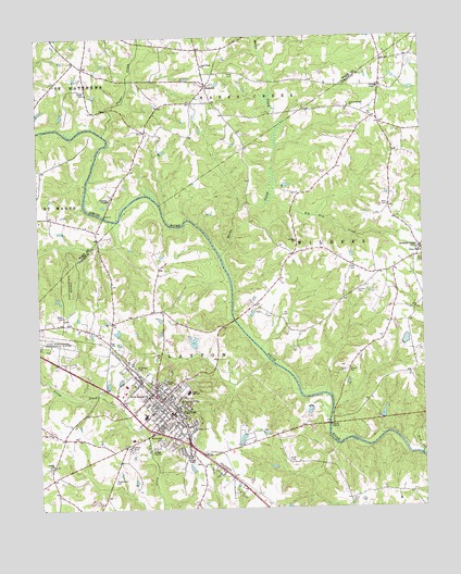
Clayton, NC USGS Topographic Map
Click on map above to begin viewing in our Map Viewer.

This topographic map contains these locations and features:
Feature Name Type Latitude Longitude GNIS ID View Map
Amelia ChurchChurchN35.6371°W78.4956°980160View Map
Archer LodgePopulated PlaceN35.6940°W78.3756°980279View Map
Archer Lodge Volunteer Fire DepartmentBuildingN35.6911°W78.3787°2639136View Map
Battles Bridge (historical)BridgeN35.7263°W78.4817°1951357View Map
Baucoms BridgeBridgeN35.7027°W78.4781°1951358View Map
Big Arm CreekStreamN35.7077°W78.4239°981299View Map
BrigadoonPopulated PlaceN35.6349°W78.4678°1005082View Map
Calvary ChurchChurchN35.6960°W78.4158°982450View Map
Carolina LakeReservoirN35.7480°W78.3919°982664View Map
ClaytonPopulated PlaceN35.6507°W78.4564°1019689View Map
Clayton Elementary SchoolSchoolN35.6521°W78.4606°1006697View Map
Clayton Emergency Medical Services - Clayton Area RescueBuildingN35.6534°W78.4653°2720600View Map
Clayton Emergency ServicesBuildingN35.6508°W78.4587°2720363View Map
Clayton Fire Department Station 1BuildingN35.6538°W78.4643°2639000View Map
Clayton Fire Department Station 2BuildingN35.6417°W78.4316°2639138View Map
Clayton High SchoolSchoolN35.6495°W78.4657°1006696View Map
Clayton Police DepartmentBuildingN35.6505°W78.4585°2769732View Map
Clayton Post OfficePost OfficeN35.6463°W78.4511°2773966View Map
Clayton Village Shopping CenterLocaleN35.6557°W78.4753°1007373View Map
Clydes ChapelChurchN35.7368°W78.3883°983306View Map
Cooper High SchoolSchoolN35.6560°W78.4514°983507View Map
Country EstatesPopulated PlaceN35.6377°W78.4494°1005081View Map
Davis CemeteryCemeteryN35.6268°W78.3989°983993View Map
Doub CemeteryCemeteryN35.7407°W78.4367°984277View Map
Earp Pond DamDamN35.6685°W78.4497°999222View Map
Everett ChapelChurchN35.6388°W78.4511°984867View Map
Gay CemeteryCemeteryN35.6760°W78.4194°985612View Map
Good Hope ChurchChurchN35.7427°W78.4456°985786View Map
Hinton CemeteryCemeteryN35.6826°W78.3961°986850View Map
Hocutt Memorial ChurchChurchN35.6546°W78.4642°986866View Map
Horne CemeteryCemeteryN35.6581°W78.4596°987067View Map
Lees Crossroad ChurchChurchN35.7318°W78.3978°988315View Map
Maplewood CemeteryCemeteryN35.6428°W78.4602°989323View Map
Marks CreekStreamN35.6924°W78.4406°989346View Map
McCullers CemeteryCemeteryN35.6619°W78.4675°989552View Map
Mill CreekStreamN35.6390°W78.3756°989949View Map
Mount Vernon ChurchChurchN35.6521°W78.4542°990600View Map
Oak Grove Church (historical)ChurchN35.7327°W78.4481°1951478View Map
Poplar CreekStreamN35.7246°W78.4781°992687View Map
Pythian HomeLocaleN35.6415°W78.4703°992925View Map
R E Earp PondReservoirN35.6685°W78.4497°999221View Map
RollingwoodPopulated PlaceN35.6574°W78.4458°1005080View Map
Sasser CemeteryCemeteryN35.6615°W78.3992°994357View Map
ShotwellPopulated PlaceN35.7371°W78.4447°1006371View Map
Smith CemeteryCemeteryN35.7360°W78.4839°994950View Map
Smith Pond Number TwoReservoirN35.6668°W78.4114°999215View Map
Smith Pond Number Two DamDamN35.6668°W78.4114°999216View Map
StarmontPopulated PlaceN35.6618°W78.4561°1005078View Map
Stephenson CemeteryCemeteryN35.6285°W78.4782°995469View Map
Tippetts ChapelChurchN35.7074°W78.4767°996119View Map
Town of ClaytonCivilN35.6592°W78.4476°2406276View Map
Township of ClaytonCivilN35.6273°W78.4580°1026847View Map
Union Carbide PondReservoirN35.6452°W78.4247°999195View Map
Union Carbide Pond DamDamN35.6452°W78.4247°999196View Map
WaldenPopulated PlaceN35.6440°W78.4442°1005079View Map
Wale CemeteryCemeteryN35.7054°W78.3858°996688View Map
Wall CemeteryCemeteryN35.6893°W78.3975°996711View Map
Wall CemeteryCemeteryN35.6904°W78.3764°996712View Map
West Clayton Elementary SchoolSchoolN35.6435°W78.4699°1006695View Map
White Oak ChurchChurchN35.6932°W78.3764°997165View Map
Wodd CemeteryCemeteryN35.6371°W78.4181°997516View Map

Note: Coordinates in the location and feature list above are referenced to NAD83 datum.


Copyright (C) 2008-2024 Ryan Niemi / Sunset Dynamics ... All Rights Reserved