TopoQuest Logo
Do you find TopoQuest useful?
Help keep TopoQuest running and adding new maps/features by donating!
Bitcoin:  19c7KJd3qBynnjoSw5npx9KScwjBe4ifkT
Litecoin:  LXs6TkuXGGXo1vDsWCkWVdjQX94eUKd6ui
Home View Maps Find Maps Find Places Resources & Links


Powhatan, North Carolina Topographic Map

USGS Map Title: Powhatan, NC
USGS Map MRC: 35078E4
DRG (GeoTIFF) Download: o35078e4.tif


Neighboring USGS Topographic Map Quads:


  Garner, NC  
35078F5
 

  Clayton, NC  
35078F4
 

  Flowers, NC  
35078F3
 

  Edmondson, NC  
35078E5
 

  Powhatan, NC  
35078E4
 

  Selma, NC  
35078E3
 

  Benson, NC  
35078D5
 

  Four Oaks, NC  
35078D4
 

  Four Oaks NE, NC  
35078D3


Map MRC Location:

N36°
W79°
N36°
W78°
H8 H7 H6 H5 H4 H3 H2 H1
G8 G7 G6 G5 G4 G3 G2 G1
F8 F7 F6 F5 F4 F3 F2 F1
E8 E7 E6 E5 E4 E3 E2 E1
D8 D7 D6 D5 D4 D3 D2 D1
C8 C7 C6 C5 C4 C3 C2 C1
B8 B7 B6 B5 B4 B3 B2 B1
A8 A7 A6 A5 A4 A3 A2 A1
N35°
W79°
N35°
W78°

Powhatan, NC USGS 1:24K Topographic Map Preview:
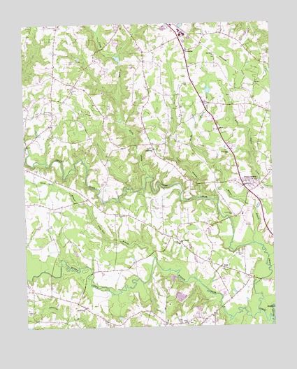
Powhatan, NC USGS Topographic Map
Click on map above to begin viewing in our Map Viewer.

This topographic map contains these locations and features:
Feature Name Type Latitude Longitude GNIS ID View Map
Averys Grove ChurchChurchN35.5485°W78.4817°980386View Map
Barham CemeteryCemeteryN35.5296°W78.3928°980554View Map
Bethesda ChurchChurchN35.5810°W78.4019°981192View Map
Center ChurchChurchN35.5974°W78.4747°982925View Map
Cooper BranchStreamN35.5529°W78.4122°983502View Map
Elizabeth ChurchChurchN35.5463°W78.4522°984688View Map
Interstate MinistriesChurchN35.5730°W78.3933°2611330View Map
Johnson Union ChurchChurchN35.5593°W78.3906°987691View Map
Johnston Regional AirportAirportN35.5414°W78.3928°997937View Map
Knollwood CemeteryCemeteryN35.5718°W78.3956°988052View Map
Langdon CemeteryCemeteryN35.5073°W78.4978°988137View Map
Little CreekStreamN35.5621°W78.4358°988606View Map
Little Creek ChurchChurchN35.5732°W78.4344°988615View Map
Middle CreekStreamN35.5060°W78.3822°989771View Map
New Bethel ChurchChurchN35.6118°W78.4028°990932View Map
Oakey Grove CemeteryCemeteryN35.5463°W78.3950°991465View Map
Oakey Grove ChurchChurchN35.5579°W78.3897°991466View Map
Piney Grove CemeteryCemeteryN35.5882°W78.4857°1988731View Map
Piney Grove ChurchChurchN35.5888°W78.4853°992352View Map
Pisgah ChurchChurchN35.5013°W78.4186°992413View Map
Poole CemeteryCemeteryN35.6093°W78.4758°992663View Map
PowhatanPopulated PlaceN35.6138°W78.4175°992779View Map
Powhatan ChurchChurchN35.6204°W78.4075°992780View Map
Reedy BranchStreamN35.5338°W78.3847°993175View Map
Sanders Grove ChurchChurchN35.5079°W78.4708°994241View Map
Short Journey SchoolSchoolN35.5343°W78.4222°994770View Map
Smithfield PlazaLocaleN35.5396°W78.3772°1007666View Map
Steep Hill BranchStreamN35.5288°W78.4344°995454View Map
Swift CreekStreamN35.5024°W78.3753°995785View Map
Wesleys ChapelChurchN35.5238°W78.3997°996981View Map
Whitley HeightsPopulated PlaceN35.5554°W78.3861°1023228View Map
Wilsons Mills Volunteer Fire Department Station 2BuildingN35.5370°W78.4250°2639116View Map

Note: Coordinates in the location and feature list above are referenced to NAD83 datum.


Copyright (C) 2008-2024 Ryan Niemi / Sunset Dynamics ... All Rights Reserved