TopoQuest Logo
Do you find TopoQuest useful?
Help keep TopoQuest running and adding new maps/features by donating!
Bitcoin:  19c7KJd3qBynnjoSw5npx9KScwjBe4ifkT
Litecoin:  LXs6TkuXGGXo1vDsWCkWVdjQX94eUKd6ui
Home View Maps Find Maps Find Places Resources & Links


Geneva East, Alabama Topographic Map

USGS Map Title: Geneva East, AL
USGS Map MRC: 31085A7
DRG (GeoTIFF) Download: o31085a7.tif


Neighboring USGS Topographic Map Quads:


  Coffee Springs, AL  
31085B8
 

  Bellwood, AL  
31085B7
 

  Clayhatchee, AL  
31085B6
 

  Geneva West, AL  
31085A8
 

  Geneva East, AL  
31085A7
 

  Hartford, AL  
31085A6
 

  Hobbs Crossroads, FL  
30085H8
 

  Izagora, FL  
30085H7
 

  Esto, FL  
30085H6


Map MRC Location:

N32°
W86°
N32°
W85°
H8 H7 H6 H5 H4 H3 H2 H1
G8 G7 G6 G5 G4 G3 G2 G1
F8 F7 F6 F5 F4 F3 F2 F1
E8 E7 E6 E5 E4 E3 E2 E1
D8 D7 D6 D5 D4 D3 D2 D1
C8 C7 C6 C5 C4 C3 C2 C1
B8 B7 B6 B5 B4 B3 B2 B1
A8 A7 A6 A5 A4 A3 A2 A1
N31°
W86°
N31°
W85°

Geneva East, AL USGS 1:24K Topographic Map Preview:
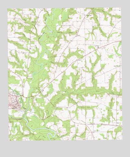
Geneva East, AL USGS Topographic Map
Click on map above to begin viewing in our Map Viewer.

This topographic map contains these locations and features:
Feature Name Type Latitude Longitude GNIS ID View Map
Adams CreekStreamN31.1005°W85.8430°112926View Map
Antioch ChurchChurchN31.0757°W85.7988°113118View Map
Blue BranchStreamN31.0460°W85.8027°114529View Map
Carter CemeteryCemeteryN31.0610°W85.8530°115659View Map
Carter Mill (historical)LocaleN31.0599°W85.8541°132106View Map
Carter Mill CreekStreamN31.0580°W85.8491°115669View Map
Crutchfield Post Office (historical)Post OfficeN31.0332°W85.7691°167366View Map
Danny Fulford LakeReservoirN31.0366°W85.8383°129617View Map
Danny Fulford Number 1 DamDamN31.0368°W85.8383°129620View Map
Danny Fulford Number 2 DamDamN31.0335°W85.8383°129618View Map
Double Bridges CreekStreamN31.0285°W85.8558°117417View Map
EunolaPopulated PlaceN31.0399°W85.8474°118055View Map
Eunola CemeteryCemeteryN31.0413°W85.8341°132123View Map
Eunola Census Designated PlaceCensusN31.0326°W85.8409°2633143View Map
Faith Temple ChurchChurchN31.0482°W85.8360°132125View Map
First Baptist ChurchChurchN31.0430°W85.8666°137034View Map
First Baptist Church of GenevaChurchN31.0363°W85.8646°137037View Map
First Episcopal Church (historical)ChurchN31.0371°W85.8669°137039View Map
First United Methodist ChurchChurchN31.0346°W85.8660°137041View Map
Flowers BranchStreamN31.0024°W85.8313°118452View Map
GenevaPopulated PlaceN31.0330°W85.8638°118889View Map
Geneva Church of God and ChristChurchN31.0346°W85.8724°1730233View Map
Geneva City CemeteryCemeteryN31.0313°W85.8644°1730143View Map
Geneva CountyCivilN31.0950°W85.8390°161556View Map
Geneva County CourthouseBuildingN31.0335°W85.8635°137042View Map
Geneva County Health DepartmentBuildingN31.0346°W85.8653°2579715View Map
Geneva County Historical Society MuseumBuildingN31.0353°W85.8651°2578986View Map
Geneva County Sheriff's OfficeBuildingN31.0406°W85.8656°2751870View Map
Geneva Municipal AirportAirportN31.0522°W85.8634°129388View Map
Geneva Police DepartmentBuildingN31.0333°W85.8633°2751844View Map
Geneva Post OfficePost OfficeN31.0346°W85.8653°167368View Map
Geneva Presbyterian ChurchChurchN31.0377°W85.8653°2580300View Map
Geneva Public LibraryBuildingN31.0353°W85.8651°2579908View Map
Geneva Rescue SquadBuildingN31.0332°W85.8632°2331007View Map
Geneva Volunteer Fire DepartmentBuildingN31.0322°W85.8677°2331014View Map
Gin BranchStreamN31.0441°W85.8124°132129View Map
Gosnen Church (historical)ChurchN31.0649°W85.7716°132130View Map
Green BranchStreamN31.0785°W85.8405°119327View Map
Greenwood PlaceBuildingN31.0379°W85.8697°2578928View Map
Hathaway BranchStreamN31.0443°W85.7599°119850View Map
High Falls Assembly of God ChurchChurchN31.1013°W85.7994°132138View Map
HighfallsPopulated PlaceN31.0985°W85.7999°156472View Map
Hodges Poultry FarmsLocaleN31.1106°W85.8389°2709203View Map
Ice Factory BranchStreamN31.0118°W85.8516°120614View Map
Jones CemeteryCemeteryN31.1179°W85.8402°158333View Map
Justice Mill CreekStreamN31.0432°W85.7524°121078View Map
Kelly Mill (historical)LocaleN31.0346°W85.8010°132146View Map
Kellys CrossroadsPopulated PlaceN31.0696°W85.7516°156549View Map
Kingdom Hall of Jehovahs WitnessesChurchN31.0512°W85.8321°2580309View Map
Lake GenevaLakeN31.0271°W85.8497°118894View Map
Mars Hill ChurchChurchN31.0868°W85.8510°132153View Map
Martin BranchStreamN31.0477°W85.8483°122314View Map
Negro Church BranchStreamN31.0463°W85.7816°123680View Map
Oak GrovePopulated PlaceN31.0871°W85.7744°132162View Map
Oak Grove ChurchChurchN31.0877°W85.7760°132163View Map
Oak Grove SchoolSchoolN31.0877°W85.7755°124107View Map
Pea RiverStreamN31.0216°W85.8583°124530View Map
Pleasant Home Baptist ChurchChurchN31.0077°W85.7816°125018View Map
Pleasant Home CemeteryCemeteryN31.0080°W85.7810°1730344View Map
Pleasant Home SchoolSchoolN31.0077°W85.7813°132171View Map
Ponderosa DamDamN31.0885°W85.8449°129642View Map
Ponderosa PondLakeN31.0893°W85.8450°132172View Map
Post Oak SchoolSchoolN31.0630°W85.7680°132174View Map
Providence CemeteryCemeteryN31.1121°W85.8424°1730145View Map
Providence ChurchChurchN31.1124°W85.8430°125321View Map
River Oaks Golf CourseLocaleN31.0251°W85.8648°2579717View Map
Roaring CreekStreamN31.1238°W85.7802°125683View Map
Rocky CreekStreamN31.0963°W85.8397°125848View Map
Roney SchoolSchoolN31.0649°W85.8155°132179View Map
Saint Elizabeth Missionary Baptist ChurchChurchN31.0345°W85.8461°2580305View Map
Saint James ChurchChurchN31.0035°W85.8166°126099View Map
Saint John Baptist ChurchChurchN31.0357°W85.8735°1730234View Map
Saint Mary's Catholic ChurchChurchN31.0404°W85.8656°2580297View Map
Saint Marys Catholic ChurchChurchN31.0371°W85.8649°137051View Map
Schuttle Mill BranchStreamN31.0846°W85.8424°126469View Map
Simmons CreekStreamN31.0702°W85.8372°126869View Map
Smith BranchStreamN31.0057°W85.8238°126988View Map
Smith BranchStreamN31.1171°W85.8297°126997View Map
Spring CreekStreamN31.0121°W85.8349°127226View Map
Spring Creek (historical)LocaleN31.0196°W85.8369°132189View Map
Spring Creek CemeteryCemeteryN31.0402°W85.7522°1926897View Map
ThurstonPopulated PlaceN31.0149°W85.7819°157158View Map
Town of Eunola (historical)CivilN31.0360°W85.8439°2406468View Map
Vanlandingham MillPopulated PlaceN31.0435°W85.7588°157195View Map
Wesley BranchStreamN31.1032°W85.8260°128739View Map
Wesley ChapelChurchN31.1180°W85.7880°153928View Map
WGEA-AM (Geneva)TowerN31.0227°W85.8710°160919View Map
WGEA-FM (Geneva)TowerN31.0227°W85.8710°161125View Map
Wheeler Church (historical)ChurchN31.0599°W85.7805°132205View Map
Wheeler Mill BranchStreamN31.0449°W85.8094°128835View Map
Wide BranchStreamN31.0005°W85.8258°128937View Map
WinoskiLocaleN31.0271°W85.8508°132207View Map

Note: Coordinates in the location and feature list above are referenced to NAD83 datum.


Copyright (C) 2008-2024 Ryan Niemi / Sunset Dynamics ... All Rights Reserved