TopoQuest Logo
Do you find TopoQuest useful?
Help keep TopoQuest running and adding new maps/features by donating!
Bitcoin:  19c7KJd3qBynnjoSw5npx9KScwjBe4ifkT
Litecoin:  LXs6TkuXGGXo1vDsWCkWVdjQX94eUKd6ui
Home View Maps Find Maps Find Places Resources & Links


Geneva West, Alabama Topographic Map

USGS Map Title: Geneva West, AL
USGS Map MRC: 31085A8
DRG (GeoTIFF) Download: o31085a8.tif


Neighboring USGS Topographic Map Quads:


  Sellersville, AL  
31086B1
 

  Coffee Springs, AL  
31085B8
 

  Bellwood, AL  
31085B7
 

  Samson, AL  
31086A1
 

  Geneva West, AL  
31085A8
 

  Geneva East, AL  
31085A7
 

  Darlington, FL  
30086H1
 

  Hobbs Crossroads, FL  
30085H8
 

  Izagora, FL  
30085H7


Map MRC Location:

N32°
W86°
N32°
W85°
H8 H7 H6 H5 H4 H3 H2 H1
G8 G7 G6 G5 G4 G3 G2 G1
F8 F7 F6 F5 F4 F3 F2 F1
E8 E7 E6 E5 E4 E3 E2 E1
D8 D7 D6 D5 D4 D3 D2 D1
C8 C7 C6 C5 C4 C3 C2 C1
B8 B7 B6 B5 B4 B3 B2 B1
A8 A7 A6 A5 A4 A3 A2 A1
N31°
W86°
N31°
W85°

Geneva West, AL USGS 1:24K Topographic Map Preview:
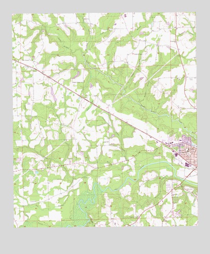
Geneva West, AL USGS Topographic Map
Click on map above to begin viewing in our Map Viewer.

This topographic map contains these locations and features:
Feature Name Type Latitude Longitude GNIS ID View Map
Beaverdam CreekStreamN31.1016°W85.9519°113764View Map
Bobby Jones LakeReservoirN31.1182°W85.9047°129652View Map
Bobby Jones Lake DamDamN31.1202°W85.9049°129653View Map
Boggy BranchStreamN31.0799°W85.9238°114657View Map
Bushy BranchStreamN31.1102°W85.9469°115303View Map
Center Ridge School (historical)SchoolN31.0063°W85.8910°132108View Map
Christian Science Church (historical)ChurchN31.0452°W85.9485°132111View Map
Church of GodChurchN31.0377°W85.8774°137031View Map
Church of PeaceChurchN31.1010°W85.9113°116146View Map
City of GenevaCivilN31.0437°W85.8763°2403687View Map
Costilla (historical)Populated PlaceN31.1071°W85.8880°167358View Map
Devco Baptist ChurchChurchN31.0207°W85.8939°2580298View Map
Eden CemeteryCemeteryN31.1213°W85.9477°143086View Map
Eden Missionary Baptist ChurchChurchN31.1218°W85.9477°117852View Map
Emmanuel Assembly of GodChurchN31.0141°W85.8753°2580303View Map
Fairlane AirportAirportN31.1052°W85.9929°2676342View Map
First United Pentecostal ChurchChurchN31.0183°W85.8920°2580302View Map
Flat BranchStreamN31.0266°W85.9505°118357View Map
Friendship Baptist ChurchChurchN31.1080°W85.8880°118662View Map
Friendship CemeteryCemeteryN31.1088°W85.8858°143089View Map
Geneva DivisionCivilN31.0508°W85.9113°165784View Map
Geneva First Assembly of GodChurchN31.0465°W85.8773°2580301View Map
Geneva High SchoolSchoolN31.0422°W85.8794°137046View Map
Geneva Wastewater Treatment PlantLocaleN31.0393°W85.8910°2579642View Map
Hugh Owen Memorial StadiumParkN31.0424°W85.8816°1730292View Map
Jack Ausley DamDamN31.0918°W85.9599°129646View Map
Jack Ausley LakeReservoirN31.0918°W85.9599°129645View Map
Joe Roeny Number 1 DamDamN31.0768°W85.9733°129636View Map
Joe Roeny Number 2 DamDamN31.0718°W85.9699°129633View Map
Keith Mill BranchStreamN31.0266°W85.8833°132145View Map
Laddon ChurchChurchN31.0499°W85.9352°158853View Map
Laddon CreekStreamN31.0343°W85.9130°121308View Map
Lakeside Estates DamDamN31.0102°W85.8849°129595View Map
Lime BranchStreamN31.0043°W85.9485°121634View Map
Limestone BranchStreamN31.0360°W85.9222°121641View Map
Little Sandy CreekStreamN31.0371°W85.9669°121878View Map
Long BranchStreamN31.0882°W85.9349°121993View Map
Long Branch ChurchChurchN31.1157°W85.9213°132148View Map
Long Branch School (historical)SchoolN31.1135°W85.9177°132149View Map
LytlePopulated PlaceN31.0757°W85.9524°156643View Map
Lytle BaySwampN31.0710°W85.9472°122132View Map
Maple Avenue Baptist ChurchChurchN31.0482°W85.8883°137048View Map
MarlPopulated PlaceN31.0905°W85.9799°156658View Map
McDuffie CemeteryCemeteryN31.0291°W85.9522°122534View Map
Midway School (historical)SchoolN31.1113°W85.8880°132157View Map
Mims Hill Assembly of GodChurchN31.0454°W85.8988°2580299View Map
Morris Mill (historical)LocaleN31.0485°W85.9749°132158View Map
Morrisville (historical)Populated PlaceN31.0549°W85.9110°163879View Map
New Bethel African Methodist Episcopal ChurchChurchN31.0343°W85.8791°150881View Map
New Prospect ChurchChurchN31.0988°W85.9883°123880View Map
Pleasant Ridge CemeteryCemeteryN31.0854°W85.9522°1730329View Map
Pleasant Ridge United Methodist ChurchChurchN31.0849°W85.9524°125034View Map
Riverside Heights High School (historical)SchoolN31.0371°W85.8858°151651View Map
Sandy CreekStreamN31.0193°W85.9447°126374View Map
Sellers BranchStreamN31.0721°W85.9144°126535View Map
SomersetPopulated PlaceN31.0213°W85.8927°132188View Map
Southside ChurchChurchN31.0182°W85.8922°127148View Map
SpectraCare Health Systems Geneva County ClinicBuildingN31.0479°W85.8907°2580053View Map
Steep HollowValleyN31.0468°W85.9888°127351View Map
Sunset Memorial GardensCemeteryN31.0652°W85.9302°132192View Map
The Church of Jesus Christ of Latter Day SaintsChurchN31.0683°W85.8829°2580304View Map
Threemile BranchStreamN31.0296°W85.8902°127946View Map
VaughanvillePopulated PlaceN31.0060°W85.9144°132198View Map
Vaughanville CemeteryCemeteryN31.0060°W85.9152°158338View Map
Vaughanville ChurchChurchN31.0060°W85.9152°153836View Map
Vaughn School (historical)SchoolN31.0052°W85.9149°132199View Map
Westside United Methodist ChurchChurchN31.0488°W85.8883°1730235View Map
Windham School (historical)SchoolN31.0182°W85.9713°132206View Map
Wiregrass Hospital AirportAirportN31.0496°W85.8916°129386View Map
Wiregrass Medical CenterHospitalN31.0488°W85.8912°137045View Map
Wiregrass Nursing HomeBuildingN31.0479°W85.8894°2578941View Map

Note: Coordinates in the location and feature list above are referenced to NAD83 datum.


Copyright (C) 2008-2024 Ryan Niemi / Sunset Dynamics ... All Rights Reserved