TopoQuest Logo
Do you find TopoQuest useful?
Help keep TopoQuest running and adding new maps/features by donating!
Bitcoin:  19c7KJd3qBynnjoSw5npx9KScwjBe4ifkT
Litecoin:  LXs6TkuXGGXo1vDsWCkWVdjQX94eUKd6ui
Home View Maps Find Maps Find Places Resources & Links


Coffee Springs, Alabama Topographic Map

USGS Map Title: Coffee Springs, AL
USGS Map MRC: 31085B8
DRG (GeoTIFF) Download: o31085b8.tif


Neighboring USGS Topographic Map Quads:


  Ino, AL  
31086C1
 

  Goodman, AL  
31085C8
 

  Enterprise, AL  
31085C7
 

  Sellersville, AL  
31086B1
 

  Coffee Springs, AL  
31085B8
 

  Bellwood, AL  
31085B7
 

  Samson, AL  
31086A1
 

  Geneva West, AL  
31085A8
 

  Geneva East, AL  
31085A7


Map MRC Location:

N32°
W86°
N32°
W85°
H8 H7 H6 H5 H4 H3 H2 H1
G8 G7 G6 G5 G4 G3 G2 G1
F8 F7 F6 F5 F4 F3 F2 F1
E8 E7 E6 E5 E4 E3 E2 E1
D8 D7 D6 D5 D4 D3 D2 D1
C8 C7 C6 C5 C4 C3 C2 C1
B8 B7 B6 B5 B4 B3 B2 B1
A8 A7 A6 A5 A4 A3 A2 A1
N31°
W86°
N31°
W85°

Coffee Springs, AL USGS 1:24K Topographic Map Preview:
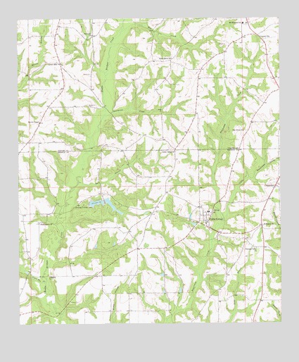
Coffee Springs, AL USGS Topographic Map
Click on map above to begin viewing in our Map Viewer.

This topographic map contains these locations and features:
Feature Name Type Latitude Longitude GNIS ID View Map
Beargrass CreekStreamN31.2096°W85.9591°113695View Map
Bellwood-Coffee Springs DivisionCivilN31.1552°W85.8859°165783View Map
Bull BranchStreamN31.1546°W85.9847°132097View Map
Bull BranchStreamN31.1832°W85.9713°115174View Map
Castleberry BranchStreamN31.2385°W85.9141°135313View Map
Cedar BranchStreamN31.2016°W85.9566°135314View Map
Center RidgePopulated PlaceN31.1960°W85.9249°143080View Map
Center Ridge Methodist ChurchChurchN31.1957°W85.9252°115864View Map
Center Ridge School (historical)SchoolN31.1955°W85.9255°132107View Map
Center School (historical)SchoolN31.1413°W85.9474°132109View Map
Central CityPopulated PlaceN31.2432°W85.8849°154446View Map
ChancellorPopulated PlaceN31.1816°W85.8772°115933View Map
Chancellor ChurchChurchN31.1805°W85.8785°132110View Map
Chancellor Post OfficePost OfficeN31.1823°W85.8771°2789061View Map
Coffee SpringsPopulated PlaceN31.1646°W85.9094°116355View Map
Coffee SpringsSpringN31.1716°W85.9055°143081View Map
Coffee Springs CemeteryCemeteryN31.1713°W85.9094°143082View Map
Coffee Springs Church of ChristChurchN31.1730°W85.9138°143083View Map
Coffee Springs Elementary SchoolSchoolN31.1707°W85.9091°143084View Map
Coffee Springs High SchoolSchoolN31.1710°W85.9097°137032View Map
Coffee Springs Methodist ChurchChurchN31.1696°W85.9091°143085View Map
Coffee Springs Post OfficePost OfficeN31.1668°W85.9105°167391View Map
Coffee Springs Volunteer Fire DepartmentBuildingN31.1666°W85.9105°2331073View Map
Corinth Church (historical)ChurchN31.2468°W85.9347°135317View Map
Dwight Brandon DamDamN31.1652°W85.8833°129683View Map
Dwight Brandon LakeReservoirN31.1652°W85.8833°129684View Map
Ed Averett Pond Dam Number 2DamN31.2268°W85.8883°129725View Map
Ed Averett Pond Number 2ReservoirN31.2268°W85.8883°129724View Map
Edwin Averett DamDamN31.1718°W85.8916°129689View Map
Edwin Averett LakeReservoirN31.1718°W85.8916°129688View Map
El Bethel Baptist ChurchChurchN31.1655°W85.8835°158821View Map
El Bethel CemeteryCemeteryN31.1649°W85.8833°143087View Map
EppersonLocaleN31.1621°W85.9499°132122View Map
First Baptist Church of Coffee SpringsChurchN31.1707°W85.9108°143088View Map
Frank Denman DamDamN31.1618°W85.9999°129679View Map
Geneva County LakeReservoirN31.1747°W85.9628°118892View Map
Geneva County Lake Number One DamDamN31.1735°W85.9599°129691View Map
Geneva County Number 2 DamDamN31.1718°W85.9666°129690View Map
Holloway ChurchChurchN31.2435°W85.9638°120266View Map
Lake HulonReservoirN31.2257°W85.9052°1699933View Map
Little Beaverdam CreekStreamN31.1674°W85.9024°121704View Map
Little Elam Baptist ChurchChurchN31.2318°W85.9788°149975View Map
Little Elam CemeteryCemeteryN31.2321°W85.9788°157721View Map
Marshall Mill (historical)LocaleN31.1463°W85.9963°132154View Map
Marvin Chapel Assembly of God ChurchChurchN31.2077°W85.9897°152239View Map
Marvin Chapel CemeteryCemeteryN31.2071°W85.9899°137075View Map
Mill CreekStreamN31.2452°W85.9494°122753View Map
Moore CemeteryCemeteryN31.2277°W85.9647°122994View Map
Mount Carmel CemeteryCemeteryN31.1638°W85.9163°143090View Map
Mount Carmel Primitive Baptist ChurchChurchN31.1643°W85.9158°143091View Map
Mount Pleasant Baptist ChurchChurchN31.2482°W85.8905°154107View Map
Mount Pleasant CemeteryCemeteryN31.2474°W85.8905°137082View Map
Mount Pleasant SchoolSchoolN31.2479°W85.8922°123373View Map
Murdock PondReservoirN31.1692°W85.9180°129686View Map
Murdock Pond DamDamN31.1685°W85.9183°129685View Map
Nichols School (historical)SchoolN31.2271°W85.9138°135394View Map
Oak Grove ChurchChurchN31.2041°W85.8922°124072View Map
Pleasant Valley CemeteryCemeteryN31.1563°W85.8877°143092View Map
Pleasant Valley Missionary Baptist ChurchChurchN31.1560°W85.8866°153012View Map
Renzol Nichols LakeReservoirN31.2252°W85.9333°129720View Map
Renzol Nichols Lake DamDamN31.2252°W85.9333°129719View Map
Shady Grove CemeteryCemeteryN31.1668°W85.9897°1730139View Map
Shady Grove ChurchChurchN31.1666°W85.9899°126592View Map
SpearsPopulated PlaceN31.1449°W85.9855°127172View Map
Tight Eye CreekStreamN31.1424°W85.9874°153694View Map
Town of Coffee SpringsCivilN31.1664°W85.9103°2406288View Map
Union Grove Baptist ChurchChurchN31.2340°W85.9260°150022View Map

Note: Coordinates in the location and feature list above are referenced to NAD83 datum.


Copyright (C) 2008-2025 Ryan Niemi / Sunset Dynamics ... All Rights Reserved