TopoQuest Logo
Do you find TopoQuest useful?
Help keep TopoQuest running and adding new maps/features by donating!
Bitcoin:  19c7KJd3qBynnjoSw5npx9KScwjBe4ifkT
Litecoin:  LXs6TkuXGGXo1vDsWCkWVdjQX94eUKd6ui
Home View Maps Find Maps Find Places Resources & Links


Mason, Tennessee Topographic Map

USGS Map Title: Mason, TN
USGS Map MRC: 35089D5
DRG (GeoTIFF) Download: o35089d5.tif


Neighboring USGS Topographic Map Quads:


  Covington, TN  
35089E6
 

  Gift, TN  
35089E5
 

  Turnpike, TN  
35089E4
 

  Brighton, TN  
35089D6
 

  Mason, TN  
35089D5
 

  Stanton, TN  
35089D4
 

  Arlington, TN  
35089C6
 

  Gallaway, TN  
35089C5
 

  Lambert, TN  
35089C4


Map MRC Location:

N36°
W90°
N36°
W89°
H8 H7 H6 H5 H4 H3 H2 H1
G8 G7 G6 G5 G4 G3 G2 G1
F8 F7 F6 F5 F4 F3 F2 F1
E8 E7 E6 E5 E4 E3 E2 E1
D8 D7 D6 D5 D4 D3 D2 D1
C8 C7 C6 C5 C4 C3 C2 C1
B8 B7 B6 B5 B4 B3 B2 B1
A8 A7 A6 A5 A4 A3 A2 A1
N35°
W90°
N35°
W89°

Mason, TN USGS 1:24K Topographic Map Preview:
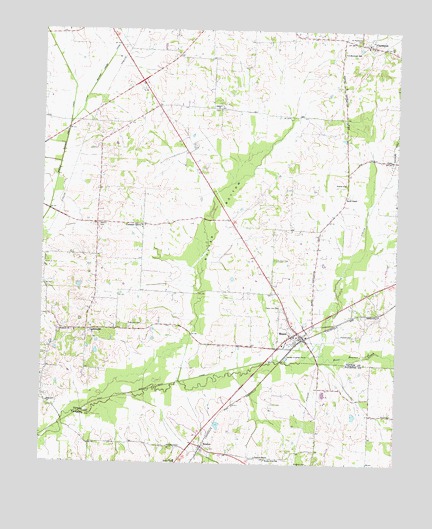
Mason, TN USGS Topographic Map
Click on map above to begin viewing in our Map Viewer.

This topographic map contains these locations and features:
Feature Name Type Latitude Longitude GNIS ID View Map
Baxter BottomBasinN35.4462°W89.5629°1276504View Map
Beech ChapelChurchN35.4523°W89.5176°1276805View Map
Beech Chapel CemeteryCemeteryN35.4523°W89.5184°1317106View Map
Belmont School (historical)SchoolN35.3890°W89.5087°1319792View Map
BradenPopulated PlaceN35.3795°W89.5681°1305377View Map
Braden Baptist ChurchChurchN35.3793°W89.5676°1319794View Map
Braden SchoolSchoolN35.3754°W89.5773°1278156View Map
Braden Volunteer Fire DepartmentBuildingN35.4101°W89.5402°2654177View Map
Braden-Sinai SchoolSchoolN35.3762°W89.5454°1278157View Map
Brodnax CemeteryCemeteryN35.3751°W89.5301°1278450View Map
Canaan GrovePopulated PlaceN35.4437°W89.5898°1279488View Map
Canaan Grove ChurchChurchN35.4429°W89.5901°1317116View Map
Canaan Grove School (historical)SchoolN35.4434°W89.5901°1317117View Map
Cedar Hill CemeteryCemeteryN35.4204°W89.5406°1280066View Map
CharlestonPopulated PlaceN35.4959°W89.5090°1305865View Map
Charleston Baptist ChurchChurchN35.4962°W89.5109°1644837View Map
Charleston CemeteryCemeteryN35.4954°W89.5103°1957927View Map
Charleston United Methodist ChurchChurchN35.4954°W89.5095°1957928View Map
Charleston Volunteer Fire DepartmentBuildingN35.4984°W89.5237°2653637View Map
Commissioner District 7CivilN35.4351°W89.6056°2464647View Map
Douglas ChapelChurchN35.3793°W89.5795°1282728View Map
Douglas Chapel CemeteryCemeteryN35.3792°W89.5790°1319805View Map
East Beaver Creek CanalCanalN35.3951°W89.5920°1269552View Map
EbenezerPopulated PlaceN35.4140°W89.6181°1647399View Map
Ebenezer CemeteryCemeteryN35.4123°W89.6187°1317137View Map
Ebenezer ChurchChurchN35.4129°W89.6190°1283468View Map
Fondren TempleChurchN35.3770°W89.5490°1284553View Map
GainesvillePopulated PlaceN35.4134°W89.6092°1285071View Map
Gainesville School (historical)SchoolN35.4143°W89.6076°1317145View Map
Hopewell ChurchChurchN35.3926°W89.6229°1288303View Map
Little Beaver Creek CanalCanalN35.4920°W89.6017°1291375View Map
Malone CemeteryCemeteryN35.4437°W89.6056°1292538View Map
MasonPopulated PlaceN35.4118°W89.5329°1292876View Map
Mason City HallBuildingN35.4123°W89.5342°1317158View Map
Mason Division (historical)CensusN35.4342°W89.5276°1648982View Map
Mason Police DepartmentBuildingN35.4120°W89.5337°2765724View Map
Mason Post OfficePost OfficeN35.4097°W89.5397°1650732View Map
Mason School (historical)SchoolN35.4123°W89.5376°1317159View Map
Mason School (historical)SchoolN35.4093°W89.5398°1317160View Map
Mason Volunteer Fire DepartmentBuildingN35.4122°W89.5332°2653653View Map
Middle Beaver Creek CanalCanalN35.4542°W89.6209°1269796View Map
Phelan School (historical)SchoolN35.4954°W89.5112°1317181View Map
Pipkins CemeteryCemeteryN35.4124°W89.5147°1297700View Map
Pleasant Grove Church (historical)ChurchN35.4792°W89.5879°1317182View Map
Porter CemeteryCemeteryN35.4120°W89.5151°1298252View Map
Robinson CemeteryCemeteryN35.4140°W89.5942°1299687View Map
Saint Matthews CemeteryCemeteryN35.4970°W89.5137°1300486View Map
Saint Matthews ChurchChurchN35.4934°W89.5195°1317196View Map
Saint Matthews SchoolSchoolN35.4940°W89.5195°1300488View Map
Saint Paul CemeteryCemeteryN35.4340°W89.5431°1300492View Map
Saint Paul Church (historical)ChurchN35.4345°W89.5431°1317198View Map
Salem CemeteryCemeteryN35.4790°W89.5626°1317201View Map
Salem ChurchChurchN35.4784°W89.5634°1300547View Map
Salem School (historical)SchoolN35.4781°W89.5620°1317202View Map
Town of MasonCivilN35.4124°W89.5434°2406106View Map
Trinity CemeteryCemeteryN35.4559°W89.5184°1317212View Map
Trinity ChurchChurchN35.4559°W89.5184°1272885View Map

Note: Coordinates in the location and feature list above are referenced to NAD83 datum.


Copyright (C) 2008-2025 Ryan Niemi / Sunset Dynamics ... All Rights Reserved