TopoQuest Logo
Do you find TopoQuest useful?
Help keep TopoQuest running and adding new maps/features by donating!
Bitcoin:  19c7KJd3qBynnjoSw5npx9KScwjBe4ifkT
Litecoin:  LXs6TkuXGGXo1vDsWCkWVdjQX94eUKd6ui
Home View Maps Find Maps Find Places Resources & Links


Gillsburg, Mississippi Topographic Map

USGS Map Title: Gillsburg, MS
USGS Map MRC: 31090A6
DRG (GeoTIFF) Download: o31090a6.tif


Neighboring USGS Topographic Map Quads:


  Liberty, MS  
31090B7
 

  Peoria, MS  
31090B6
 

  Lake Tangipahoa, MS  
31090B5
 

  Street, MS  
31090A7
 

  Gillsburg, MS  
31090A6
 

  Terrys Creek, MS  
31090A5
 

  Chipola, LA  
30090H7
 

  Liverpool, LA  
30090H6
 

  Kentwood, LA  
30090H5


Map MRC Location:

N32°
W91°
N32°
W90°
H8 H7 H6 H5 H4 H3 H2 H1
G8 G7 G6 G5 G4 G3 G2 G1
F8 F7 F6 F5 F4 F3 F2 F1
E8 E7 E6 E5 E4 E3 E2 E1
D8 D7 D6 D5 D4 D3 D2 D1
C8 C7 C6 C5 C4 C3 C2 C1
B8 B7 B6 B5 B4 B3 B2 B1
A8 A7 A6 A5 A4 A3 A2 A1
N31°
W91°
N31°
W90°

Gillsburg, MS USGS 1:24K Topographic Map Preview:
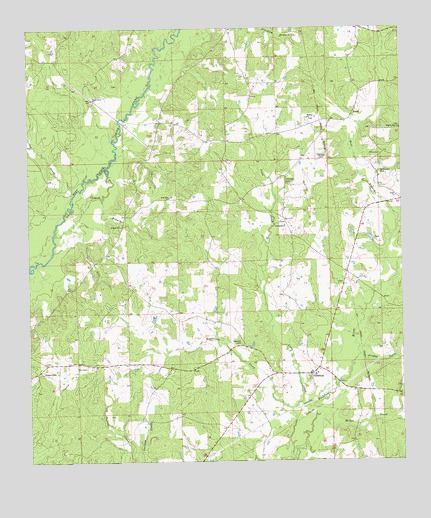
Gillsburg, MS USGS Topographic Map
Click on map above to begin viewing in our Map Viewer.

This topographic map contains these locations and features:
Feature Name Type Latitude Longitude GNIS ID View Map
Bates CemeteryCemeteryN31.1149°W90.7165°685201View Map
Bates School (historical)SchoolN31.0927°W90.6754°685204View Map
Benjamin Wall CemeteryCemeteryN31.0285°W90.6976°685207View Map
Bethlehem Baptist ChurchChurchN31.1080°W90.7307°685209View Map
Bethlehem CemeteryCemeteryN31.1079°W90.7304°685210View Map
Carter-Evans CemeteryCemeteryN31.0266°W90.6940°685225View Map
Casey-Powell CemeteryCemeteryN31.0527°W90.6654°685227View Map
Cockerham CemeteryCemeteryN31.1029°W90.7026°685238View Map
Colwell BranchStreamN31.0657°W90.7418°668722View Map
Cuba CreekStreamN31.0010°W90.6632°669006View Map
Felder-Williams CemeteryCemeteryN31.0088°W90.6481°685262View Map
Friday CreekStreamN31.0307°W90.6395°670206View Map
GillsburgPopulated PlaceN31.0252°W90.6559°690914View Map
Gillsburg Baptist ChurchChurchN31.0252°W90.6545°685274View Map
Gillsburg CemeteryCemeteryN31.0246°W90.6545°685275View Map
Gillsburg Rural Volunteer Fire DepartmentBuildingN31.0255°W90.6586°2668089View Map
Gordon CemeteryCemeteryN31.0635°W90.6337°685280View Map
Gordon Mill (historical)LocaleN31.0563°W90.6268°685281View Map
Harness CemeteryCemeteryN31.0877°W90.6531°670946View Map
Holden CemeteryCemeteryN31.0904°W90.7098°685293View Map
Holden CemeteryCemeteryN31.1016°W90.6395°685294View Map
Hughes-Lawson CemeteryCemeteryN31.0210°W90.6648°685300View Map
HuronPopulated PlaceN31.1002°W90.6415°691951View Map
Hurricane CreekStreamN31.0152°W90.6626°671608View Map
Jerusalem CemeteryCemeteryN31.0685°W90.6645°685306View Map
Jerusalem ChurchChurchN31.0682°W90.6648°671851View Map
Lea CemeteryCemeteryN31.0502°W90.7382°672335View Map
Lea CemeteryCemeteryN31.1007°W90.6393°685311View Map
Lea-Davis CemeteryCemeteryN31.0105°W90.7498°685313View Map
Little CreekStreamN31.0780°W90.7348°672590View Map
Love CreekStreamN31.1235°W90.7015°672900View Map
Madison-Bean CemeteryCemeteryN31.0113°W90.7498°685321View Map
McClendon CemeteryCemeteryN31.0832°W90.6320°673304View Map
McDaniel-Travis CemeteryCemeteryN31.0763°W90.6270°685330View Map
McDowell CemeteryCemeteryN31.0857°W90.7470°685327View Map
Midway School (historical)SchoolN31.0716°W90.7173°685332View Map
Miller CreekStreamN31.0130°W90.6545°673641View Map
Monroe-Brumfield CemeteryCemeteryN31.1127°W90.6979°685336View Map
Morgan-Gordon CemeteryCemeteryN31.0516°W90.6448°685339View Map
New Star Church (historical)ChurchN31.0491°W90.6870°685354View Map
New Zion CemeteryCemeteryN31.0760°W90.7023°685355View Map
New Zion ChurchChurchN31.0763°W90.7037°674867View Map
Newman CemeteryCemeteryN31.0346°W90.6798°674906View Map
Newman CemeteryCemeteryN31.1229°W90.6354°685352View Map
Old Gillsburg CemeteryCemeteryN31.0230°W90.6562°685361View Map
Pilgrim Rest CemeteryCemeteryN31.0966°W90.6251°675742View Map
Pilgrim Rest ChurchChurchN31.0960°W90.6254°675744View Map
Polk-Tate CemeteryCemeteryN31.0271°W90.6690°685369View Map
Reynolds School (historical)SchoolN31.0213°W90.7090°685375View Map
Richland CemeteryCemeteryN31.0804°W90.6643°676639View Map
Richmond School (historical)SchoolN31.0716°W90.6668°685377View Map
Shady Grove CemeteryCemeteryN31.1038°W90.7287°685388View Map
Shady Grove ChurchChurchN31.1046°W90.7293°677554View Map
Smith DitchValleyN31.0640°W90.7333°677934View Map
Stewart CemeteryCemeteryN31.0260°W90.7459°678281View Map
Supervisor District 5CivilN31.0762°W90.6999°711773View Map
Taylor Store (historical)LocaleN31.0335°W90.6776°685406View Map
Taylor Williams CemeteryCemeteryN31.0368°W90.6793°685407View Map
Tickfaw (historical)LocaleN31.0849°W90.6293°685413View Map
Tickfaw CemeteryCemeteryN31.0982°W90.6565°685414View Map
Tickfaw ChurchChurchN31.0991°W90.6570°678752View Map
Tickfaw Church (historical)ChurchN31.0441°W90.6318°685415View Map
Travis Store (historical)LocaleN31.1046°W90.7273°685420View Map
Wall CemeteryCemeteryN31.0466°W90.6645°685423View Map
Wall CemeteryCemeteryN31.0274°W90.7345°679282View Map
West Branch Tickfaw RiverStreamN31.0543°W90.6273°679474View Map
Williams Chapel (historical)ChurchN31.0646°W90.6998°685435View Map
Zeagler CemeteryCemeteryN31.0202°W90.6762°685440View Map

Note: Coordinates in the location and feature list above are referenced to NAD83 datum.


Copyright (C) 2008-2025 Ryan Niemi / Sunset Dynamics ... All Rights Reserved