TopoQuest Logo
Do you find TopoQuest useful?
Help keep TopoQuest running and adding new maps/features by donating!
Bitcoin:  19c7KJd3qBynnjoSw5npx9KScwjBe4ifkT
Litecoin:  LXs6TkuXGGXo1vDsWCkWVdjQX94eUKd6ui
Home View Maps Find Maps Find Places Resources & Links


Liverpool, Louisiana Topographic Map

USGS Map Title: Liverpool, LA
USGS Map MRC: 30090H6
DRG (GeoTIFF) Download: o30090h6.tif


Neighboring USGS Topographic Map Quads:


  Street, MS  
31090A7
 

  Gillsburg, MS  
31090A6
 

  Terrys Creek, MS  
31090A5
 

  Chipola, LA  
30090H7
 

  Liverpool, LA  
30090H6
 

  Kentwood, LA  
30090H5
 

  Hatchersville, LA  
30090G7
 

  Greensburg, LA  
30090G6
 

  Roseland, LA  
30090G5


Map MRC Location:

N31°
W91°
N31°
W90°
H8 H7 H6 H5 H4 H3 H2 H1
G8 G7 G6 G5 G4 G3 G2 G1
F8 F7 F6 F5 F4 F3 F2 F1
E8 E7 E6 E5 E4 E3 E2 E1
D8 D7 D6 D5 D4 D3 D2 D1
C8 C7 C6 C5 C4 C3 C2 C1
B8 B7 B6 B5 B4 B3 B2 B1
A8 A7 A6 A5 A4 A3 A2 A1
N30°
W91°
N30°
W90°

Liverpool, LA USGS 1:24K Topographic Map Preview:
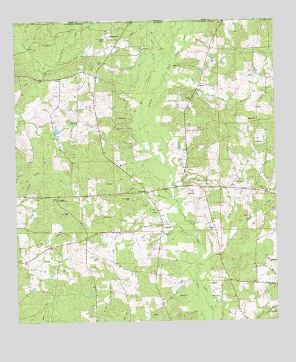
Liverpool, LA USGS Topographic Map
Click on map above to begin viewing in our Map Viewer.

This topographic map contains these locations and features:
Feature Name Type Latitude Longitude GNIS ID View Map
Alford CemeteryCemeteryN30.9330°W90.6454°559759View Map
Allen CemeteryCemeteryN30.9274°W90.6673°559761View Map
Anglin CemeteryCemeteryN30.9581°W90.7206°559784View Map
Bates CemeteryCemeteryN30.9599°W90.6970°559831View Map
Bridges BranchStreamN30.9424°W90.6837°560272View Map
Bridges CemeteryCemeteryN30.8907°W90.6548°560273View Map
Carruth CemeteryCemeteryN30.9185°W90.7090°560368View Map
Center ChurchChurchN30.9068°W90.7351°560386View Map
Centerville SchoolSchoolN30.9088°W90.7184°560388View Map
Collins CreekStreamN30.9824°W90.7295°560452View Map
Cotton Patch BranchStreamN30.9235°W90.6757°560479View Map
Crittenden CemeteryCemeteryN30.9005°W90.6523°560532View Map
Crittenden CreekStreamN30.8991°W90.6618°560533View Map
Crooked CreekStreamN30.9230°W90.6307°560543View Map
Dawson CemeteryCemeteryN30.9582°W90.6354°560596View Map
Day BranchStreamN30.9771°W90.6784°560597View Map
Day CemeteryCemeteryN30.9724°W90.6620°560598View Map
Day ChurchChurchN30.9199°W90.6826°560599View Map
Day Church CreekStreamN30.9235°W90.6754°560600View Map
EasleyvillePopulated PlaceN30.9288°W90.6876°1628682View Map
Frazier CemeteryCemeteryN30.9824°W90.7101°1628683View Map
Halley BranchStreamN30.9738°W90.6862°560933View Map
Jackson CemeteryCemeteryN30.9143°W90.6573°1627346View Map
Lee CemeteryCemeteryN30.9568°W90.7362°1627467View Map
LiverpoolPopulated PlaceN30.9152°W90.6804°1627551View Map
Martin CemeteryCemeteryN30.9810°W90.6706°1627615View Map
McCoy CemeteryCemeteryN30.9313°W90.7468°1627629View Map
Mill CreekStreamN30.9463°W90.6865°1627663View Map
Mud CreekStreamN30.8793°W90.6298°1627725View Map
New Zion Baptist ChurchChurchN30.9280°W90.6300°2602495View Map
New Zion ChurchChurchN30.9280°W90.6298°1628690View Map
New Zion SchoolSchoolN30.9293°W90.6323°1627774View Map
North Helena Volunteer Fire DepartmentBuildingN30.9084°W90.7179°2691844View Map
Old Venable CemeteryCemeteryN30.9260°W90.6951°1628691View Map
Peters CreekStreamN30.9074°W90.6490°1627904View Map
Pine Ridge ChurchChurchN30.8907°W90.6334°1627930View Map
Pine Ridge United Methodist ChurchChurchN30.8900°W90.6293°2602588View Map
Rand BranchStreamN30.9110°W90.6668°1628023View Map
Red Bluff ChurchChurchN30.9885°W90.6890°1628030View Map
Smith CemeteryCemeteryN30.9488°W90.6348°1628693View Map
Spring AirportAirportN30.9737°W90.6652°1632791View Map
Spring BranchStreamN30.8796°W90.6293°1628285View Map
Spring CreekStreamN30.9710°W90.6862°1628286View Map
Spring Creek ChurchChurchN30.9327°W90.6587°1628288View Map
Spring Creek Missionary Baptist ChurchChurchN30.9330°W90.6581°2602824View Map
Venable ChurchChurchN30.9241°W90.6884°1628421View Map
Ward OneCivilN30.9627°W90.7315°1628585View Map
Young CemeteryCemeteryN30.9313°W90.6687°1628543View Map

Note: Coordinates in the location and feature list above are referenced to NAD83 datum.


Copyright (C) 2008-2025 Ryan Niemi / Sunset Dynamics ... All Rights Reserved