TopoQuest Logo
Do you find TopoQuest useful?
Help keep TopoQuest running and adding new maps/features by donating!
Bitcoin:  19c7KJd3qBynnjoSw5npx9KScwjBe4ifkT
Litecoin:  LXs6TkuXGGXo1vDsWCkWVdjQX94eUKd6ui
Home View Maps Find Maps Find Places Resources & Links


Seville, Florida Topographic Map

USGS Map Title: Seville, FL
USGS Map MRC: 29081C4
DRG (GeoTIFF) Download: o29081c4.tif


Neighboring USGS Topographic Map Quads:


  Crescent City, FL  
29081D5
 

  Saint Johns Park, FL  
29081D4
 

  Bunnell, FL  
29081D3
 

  Welaka SE, FL  
29081C5
 

  Seville, FL  
29081C4
 

  Codys Corner, FL  
29081C3
 

  Astor, FL  
29081B5
 

  Pierson, FL  
29081B4
 

  Lake Dias, FL  
29081B3


Map MRC Location:

N30°
W82°
N30°
W81°
H8 H7 H6 H5 H4 H3 H2 H1
G8 G7 G6 G5 G4 G3 G2 G1
F8 F7 F6 F5 F4 F3 F2 F1
E8 E7 E6 E5 E4 E3 E2 E1
D8 D7 D6 D5 D4 D3 D2 D1
C8 C7 C6 C5 C4 C3 C2 C1
B8 B7 B6 B5 B4 B3 B2 B1
A8 A7 A6 A5 A4 A3 A2 A1
N29°
W82°
N29°
W81°

Seville, FL USGS 1:24K Topographic Map Preview:
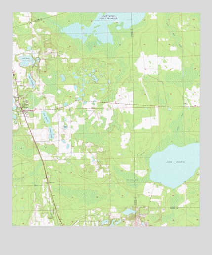
Seville, FL USGS Topographic Map
Click on map above to begin viewing in our Map Viewer.

This topographic map contains these locations and features:
Feature Name Type Latitude Longitude GNIS ID View Map
Anchor Baptist ChurchChurchN29.3176°W81.4909°2452369View Map
BakerstownPopulated PlaceN29.3480°W81.4915°301666View Map
Budd Darling HeliportAirportN29.3428°W81.4806°309895View Map
Causey Family CemeteryCemeteryN29.3089°W81.4931°2581861View Map
Cone CemeteryCemeteryN29.3241°W81.4723°2581864View Map
ConnersvillePopulated PlaceN29.2755°W81.4759°295215View Map
Cow PondLakeN29.3467°W81.4904°280943View Map
Cowarts LakeLakeN29.3045°W81.4739°280948View Map
Harris CemeteryCemeteryN29.2982°W81.4836°2581937View Map
Haw Creek Preserve State ParkParkN29.3725°W81.4373°307364View Map
Hokey LakeLakeN29.3081°W81.4644°284132View Map
Lake DisstonLakeN29.2868°W81.3898°281592View Map
Lake JuanitaLakeN29.3349°W81.4874°284952View Map
Lake RobertsLakeN29.3136°W81.4774°289793View Map
Pentecostal Church of PiersonChurchN29.2893°W81.4714°2451877View Map
Piney Grove Free Will Baptist ChurchChurchN29.2557°W81.4724°2451878View Map
Roberts CemeteryCemeteryN29.3141°W81.4825°2581979View Map
Salt Springs IslandIslandN29.3233°W81.4126°307807View Map
Saw Grass BaySwampN29.2793°W81.4227°290704View Map
SenyahPopulated PlaceN29.3403°W81.4923°301665View Map
SevillePopulated PlaceN29.3169°W81.4926°290877View Map
Seville CemeteryCemeteryN29.3237°W81.4971°2581996View Map
Seville Lookout TowerTowerN29.3258°W81.4951°301667View Map
Seville Post OfficePost OfficeN29.3174°W81.4926°2783439View Map
Seville Public SchoolSchoolN29.3155°W81.4909°299361View Map
Seville Trinity United Methodist ChurchChurchN29.3154°W81.4956°2452370View Map
Sunny Sands Resort Mobile Home ParkPopulated PlaceN29.2510°W81.4396°2451874View Map
Volusia County Fire Services Station 43 SevilleBuildingN29.3149°W81.4921°2331227View Map
Ward Chapel African Methodist Episcopal ChurchChurchN29.3208°W81.4929°2452371View Map
WAYQ-TV (Daytona Beach)TowerN29.2864°W81.4934°310289View Map

Note: Coordinates in the location and feature list above are referenced to NAD83 datum.


Copyright (C) 2008-2025 Ryan Niemi / Sunset Dynamics ... All Rights Reserved