TopoQuest Logo
Do you find TopoQuest useful?
Help keep TopoQuest running and adding new maps/features by donating!
Bitcoin:  19c7KJd3qBynnjoSw5npx9KScwjBe4ifkT
Litecoin:  LXs6TkuXGGXo1vDsWCkWVdjQX94eUKd6ui
Home View Maps Find Maps Find Places Resources & Links


Hiddenite, North Carolina Topographic Map

USGS Map Title: Hiddenite, NC
USGS Map MRC: 35081H1
DRG (GeoTIFF) Download: o35081h1.tif


Neighboring USGS Topographic Map Quads:


  Moravian Falls, NC  
36081A2
 

  Gilreath, NC  
36081A1
 

  Osbornville, NC  
36080A8
 

  Taylorsville, NC  
35081H2
 

  Hiddenite, NC  
35081H1
 

  Central, NC  
35080H8
 

  Millersville, NC  
35081G2
 

  Stony Point, NC  
35081G1
 

  Statesville West, NC  
35080G8


Map MRC Location:

N36°
W82°
N36°
W81°
H8 H7 H6 H5 H4 H3 H2 H1
G8 G7 G6 G5 G4 G3 G2 G1
F8 F7 F6 F5 F4 F3 F2 F1
E8 E7 E6 E5 E4 E3 E2 E1
D8 D7 D6 D5 D4 D3 D2 D1
C8 C7 C6 C5 C4 C3 C2 C1
B8 B7 B6 B5 B4 B3 B2 B1
A8 A7 A6 A5 A4 A3 A2 A1
N35°
W82°
N35°
W81°

Hiddenite, NC USGS 1:24K Topographic Map Preview:
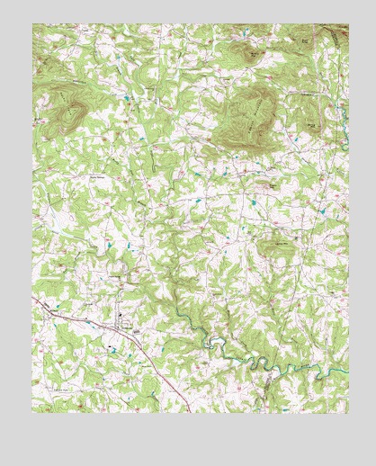
Hiddenite, NC USGS Topographic Map
Click on map above to begin viewing in our Map Viewer.

This topographic map contains these locations and features:
Feature Name Type Latitude Longitude GNIS ID View Map
Asbury MountainSummitN35.9632°W81.0384°1018859View Map
Beaverdam CreekStreamN35.9782°W81.0854°980853View Map
Berea ChurchChurchN35.9299°W81.0562°981034View Map
Big BranchStreamN35.9751°W81.0834°981349View Map
Buck KnobSummitN35.9946°W81.0154°1019369View Map
Bull BranchStreamN35.9265°W81.0992°982200View Map
Center ChurchChurchN35.9535°W81.0309°982929View Map
Cullys BranchStreamN35.8874°W81.0259°983835View Map
East Junior High SchoolSchoolN35.9276°W81.1237°1003539View Map
Fairview ChurchChurchN35.9512°W81.0431°984921View Map
Fairview ParkPopulated PlaceN35.8832°W81.1187°984929View Map
Faith TempleChurchN35.8910°W81.0551°984967View Map
Fowler MountainSummitN35.9479°W81.0317°1020341View Map
Greasy CreekStreamN35.9329°W81.1126°986006View Map
Gryder-Teague AirportAirportN35.9187°W81.1230°998001View Map
Harve CreekStreamN35.8899°W81.0179°986476View Map
HiddenitePopulated PlaceN35.9037°W81.0906°986733View Map
Hiddenite Census Designated PlaceCensusN35.9053°W81.0860°2628635View Map
Hiddenite Elementary SchoolSchoolN35.9065°W81.0901°1003540View Map
Hiddenite Fire DepartmentBuildingN35.9021°W81.0912°2638867View Map
Hiddenite Post OfficePost OfficeN35.9009°W81.0896°2774095View Map
Hopewell ChurchChurchN35.9812°W81.0487°987055View Map
Lackey MountainSummitN35.9293°W81.0295°988070View Map
Liberty ChurchChurchN35.8832°W81.0967°988415View Map
Linneys Grove ChurchChurchN35.9793°W81.0759°988515View Map
MidwayPopulated PlaceN35.9074°W81.1187°989818View Map
Mill CreekStreamN35.9679°W81.0809°989951View Map
Miller CreekStreamN35.8929°W81.0373°990001View Map
New Hope (historical)Populated PlaceN35.9429°W81.0059°1001735View Map
Pisgah ChurchChurchN35.9132°W81.0054°992416View Map
Poplar Springs ChurchChurchN35.9776°W81.0134°992709View Map
Rocky FaceSummitN35.9724°W81.1087°993582View Map
Rocky Face BranchStreamN35.9368°W81.0726°993584View Map
Rocky SpringsPopulated PlaceN35.9515°W81.1015°993629View Map
Round TopSummitN35.9904°W81.0387°1022427View Map
South River ChurchChurchN35.9135°W81.0540°995207View Map
Spring MountainSummitN35.9674°W81.0129°995357View Map
Sulphur Springs ChurchChurchN35.9179°W81.0898°995682View Map
Township of GwaltneysCivilN35.9762°W81.0551°1026357View Map
Township of SharpesCivilN35.9092°W81.0892°1026360View Map
VashtiPopulated PlaceN35.9979°W81.1054°1023074View Map
Wallace CreekStreamN35.9093°W81.0676°996723View Map
Wayfound ChurchChurchN35.9099°W81.1040°996885View Map
Zion ChapelChurchN35.9324°W81.0381°997753View Map

Note: Coordinates in the location and feature list above are referenced to NAD83 datum.


Copyright (C) 2008-2025 Ryan Niemi / Sunset Dynamics ... All Rights Reserved