TopoQuest Logo
Do you find TopoQuest useful?
Help keep TopoQuest running and adding new maps/features by donating!
Bitcoin:  19c7KJd3qBynnjoSw5npx9KScwjBe4ifkT
Litecoin:  LXs6TkuXGGXo1vDsWCkWVdjQX94eUKd6ui
Home View Maps Find Maps Find Places Resources & Links


Glen Rock, Pennsylvania Topographic Map

USGS Map Title: Glen Rock, PA
USGS Map MRC: 39076G6
DRG (GeoTIFF) Download: o39076g6.tif


Neighboring USGS Topographic Map Quads:


  West York, PA  
39076H7
 

  York, PA  
39076H6
 

  Red Lion, PA  
39076H5
 

  Seven Valleys, PA  
39076G7
 

  Glen Rock, PA  
39076G6
 

  Stewartstown, PA  
39076G5
 

  Lineboro, MD  
39076F7
 

  New Freedom, PA  
39076F6
 

  Norrisville, MD  
39076F5


Map MRC Location:

N40°
W77°
N40°
W76°
H8 H7 H6 H5 H4 H3 H2 H1
G8 G7 G6 G5 G4 G3 G2 G1
F8 F7 F6 F5 F4 F3 F2 F1
E8 E7 E6 E5 E4 E3 E2 E1
D8 D7 D6 D5 D4 D3 D2 D1
C8 C7 C6 C5 C4 C3 C2 C1
B8 B7 B6 B5 B4 B3 B2 B1
A8 A7 A6 A5 A4 A3 A2 A1
N39°
W77°
N39°
W76°

Glen Rock, PA USGS 1:24K Topographic Map Preview:
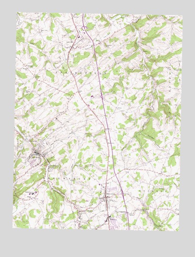
Glen Rock, PA USGS Topographic Map
Click on map above to begin viewing in our Map Viewer.

This topographic map contains these locations and features:
Feature Name Type Latitude Longitude GNIS ID View Map
AnstinePopulated PlaceN39.7543°W76.6350°1211171View Map
Arthur Hufnagel Public Library of Glen RockBuildingN39.7942°W76.7314°2100245View Map
Barshinger CreekStreamN39.8707°W76.6650°1168773View Map
Bon Air Golf CourseLocaleN39.7651°W76.7272°1213148View Map
Borough of Glen RockCivilN39.7935°W76.7307°1215745View Map
Borough of LoganvilleCivilN39.8559°W76.7079°1215752View Map
Borough of RailroadCivilN39.7596°W76.6961°1215758View Map
Borough of ShrewsburyCivilN39.7713°W76.6799°1215761View Map
Bupps Union ChurchChurchN39.8643°W76.7316°1170696View Map
Caslow SchoolSchoolN39.8293°W76.7416°1171307View Map
CentervillePopulated PlaceN39.8009°W76.7377°1171467View Map
Centerville CreekStreamN39.8026°W76.7405°1171475View Map
Chestnut Hill CemeteryCemeteryN39.7898°W76.7402°1171727View Map
Christ CemeteryCemeteryN39.7670°W76.6775°1171805View Map
Codorus ChurchChurchN39.8584°W76.6861°1172121View Map
Dunkard ValleyValleyN39.8703°W76.6778°1173611View Map
Fissels ChurchChurchN39.7673°W76.7355°1174851View Map
Foust CreekStreamN39.8012°W76.7386°1175076View Map
Friedensaals ChurchChurchN39.8434°W76.7380°1175248View Map
Glen RockPopulated PlaceN39.7932°W76.7302°1175704View Map
Glen Rock AmbulanceBuildingN39.7940°W76.7323°2722146View Map
Glen Rock CemeteryCemeteryN39.8004°W76.7286°1175705View Map
Glen Rock Hose and Ladder Company Station 59BuildingN39.7931°W76.7313°2653121View Map
Glen Rock Post OfficePost OfficeN39.7984°W76.7298°2756643View Map
Glen Rock ValleyValleyN39.7933°W76.7287°1175706View Map
GraydonPopulated PlaceN39.8543°W76.6550°1203713View Map
HametownPopulated PlaceN39.7984°W76.6791°1203744View Map
Hametown ChurchChurchN39.8070°W76.6816°1176416View Map
Hartman SchoolSchoolN39.8437°W76.6344°1176616View Map
Hildebrand School (historical)SchoolN39.8093°W76.6305°1211169View Map
HungerfordPopulated PlaceN39.7565°W76.6777°1177593View Map
KeeneyPopulated PlaceN39.7595°W76.6616°1203919View Map
Krout SchoolSchoolN39.8295°W76.7022°1178695View Map
LoganvillePopulated PlaceN39.8557°W76.7075°1179829View Map
Loganville Post OfficePost OfficeN39.8558°W76.7094°2756663View Map
Loganville Volunteer Fire Company Station 63BuildingN39.8483°W76.7114°2652889View Map
Miller SchoolSchoolN39.8229°W76.6277°1211234View Map
Mount Airy School (historical)SchoolN39.7812°W76.6733°1211170View Map
Mount Olivet ChurchChurchN39.7829°W76.6397°1181780View Map
Mount Zion CemeteryCemeteryN39.8238°W76.6698°1181894View Map
Ness CemeteryCemeteryN39.8695°W76.6722°1182270View Map
Neutzel FarmsLocaleN39.8192°W76.7478°2611285View Map
Old Mill CreekStreamN39.7550°W76.6986°2084368View Map
OrwigPopulated PlaceN39.7609°W76.6280°1204337View Map
Pennsylvania State Police Troop H York StationBuildingN39.8632°W76.7015°2754608View Map
Pierceville RunStreamN39.7907°W76.7469°1183704View Map
PotosiPopulated PlaceN39.8207°W76.6730°1204441View Map
RailroadPopulated PlaceN39.7607°W76.6983°1184600View Map
Railroad Post OfficePost OfficeN39.7606°W76.6987°2756691View Map
Railroad RunStreamN39.7610°W76.7002°2084369View Map
Reformed CemeteryCemeteryN39.7881°W76.7400°1184853View Map
Rehmeyer HollowValleyN39.8071°W76.6539°1184862View Map
Saddlers ChurchChurchN39.7737°W76.6361°1185710View Map
Saint Peters ChurchChurchN39.8384°W76.7352°1186651View Map
Schesslers SchoolSchoolN39.8562°W76.6797°1187084View Map
Seaks RunStreamN39.8465°W76.6533°1187194View Map
Seitz CemeteryCemeteryN39.7677°W76.7355°1187236View Map
Seitz SchoolSchoolN39.8320°W76.6647°1187237View Map
SeitzlandPopulated PlaceN39.7854°W76.7230°1187238View Map
Seven Valleys ChurchChurchN39.8712°W76.7389°1187269View Map
ShefferPopulated PlaceN39.7618°W76.6497°1211172View Map
Shoestring Aviation AirfieldAirportN39.7942°W76.6455°1193742View Map
ShrewsburyPopulated PlaceN39.7687°W76.6797°1187619View Map
Shrewsbury Post OfficePost OfficeN39.7529°W76.6795°2756704View Map
Shrewsbury StationPopulated PlaceN39.7573°W76.7002°1211236View Map
Shrewsbury Volunteer Fire Company Station 61BuildingN39.7689°W76.6814°2652971View Map
Shusters SchoolSchoolN39.8426°W76.7405°1187640View Map
Southern York County Forest Fire CrewBuildingN39.7937°W76.7314°2653134View Map
Southern York County LibraryBuildingN39.7530°W76.6796°2100259View Map
Susquehannock SchoolSchoolN39.7701°W76.7347°1189114View Map
TolnaPopulated PlaceN39.7620°W76.6516°1189627View Map
Tolna P O (historical)BuildingN39.7623°W76.6500°1211235View Map
Township of ShrewsburyCivilN39.7563°W76.7203°1217305View Map
Township of SpringfieldCivilN39.8268°W76.7097°1217307View Map
Trout RunStreamN39.7832°W76.7239°1189839View Map
Turnpike StationLocaleN39.7573°W76.6772°1212590View Map
Williams CemeteryCemeteryN39.8734°W76.6589°1191455View Map
Wilson FarmsLocaleN39.7661°W76.6539°2611286View Map
Winter CemeteryCemeteryN39.8257°W76.7084°1191609View Map

Note: Coordinates in the location and feature list above are referenced to NAD83 datum.


Copyright (C) 2008-2024 Ryan Niemi / Sunset Dynamics ... All Rights Reserved