TopoQuest Logo
Do you find TopoQuest useful?
Help keep TopoQuest running and adding new maps/features by donating!
Bitcoin:  19c7KJd3qBynnjoSw5npx9KScwjBe4ifkT
Litecoin:  LXs6TkuXGGXo1vDsWCkWVdjQX94eUKd6ui
Home View Maps Find Maps Find Places Resources & Links


Gold Hill, Oregon Topographic Map

USGS Map Title: Gold Hill, OR
USGS Map MRC: 42123D1
DRG (GeoTIFF) Download: o42123d1.tif


Neighboring USGS Topographic Map Quads:


  Wimer, OR  
42123E2
 

  McConville Peak, OR  
42123E1
 

  Boswell Mountain, OR  
42122E8
 

  Rogue River, OR  
42123D2
 

  Gold Hill, OR  
42123D1
 

  Sams Valley, OR  
42122D8
 

  Applegate, OR  
42123C2
 

  Mount Isabelle, OR  
42123C1
 

  Medford West, OR  
42122C8


Map MRC Location:

N43°
W124°
N43°
W123°
H8 H7 H6 H5 H4 H3 H2 H1
G8 G7 G6 G5 G4 G3 G2 G1
F8 F7 F6 F5 F4 F3 F2 F1
E8 E7 E6 E5 E4 E3 E2 E1
D8 D7 D6 D5 D4 D3 D2 D1
C8 C7 C6 C5 C4 C3 C2 C1
B8 B7 B6 B5 B4 B3 B2 B1
A8 A7 A6 A5 A4 A3 A2 A1
N42°
W124°
N42°
W123°

Gold Hill, OR USGS 1:24K Topographic Map Preview:
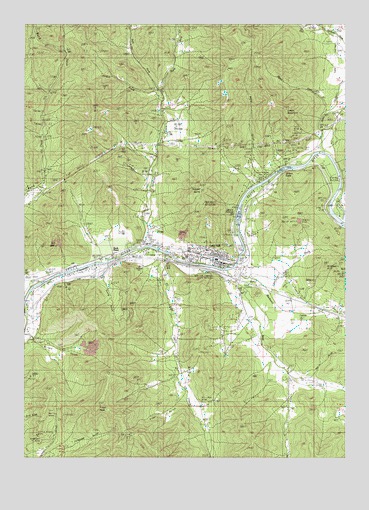
Gold Hill, OR USGS Topographic Map
Click on map above to begin viewing in our Map Viewer.

This topographic map contains these locations and features:
Feature Name Type Latitude Longitude GNIS ID View Map
Alder GulchValleyN42.3943°W123.0623°1132453View Map
Anderson MineMineN42.3801°W123.1192°1135728View Map
Bear GulchValleyN42.3818°W123.0567°1132452View Map
Ben Hur Lampman State ParkParkN42.4276°W123.0587°1122930View Map
Bill Nye MineMineN42.3910°W123.0581°1117697View Map
Blackwell CreekStreamN42.4293°W123.0453°1117794View Map
Blackwell HillSummitN42.4268°W123.0012°1117795View Map
Braden MineMineN42.4060°W123.0539°1118027View Map
Cardwell CreekStreamN42.4748°W123.0081°1132733View Map
Cemetery (historical)LocaleN42.4354°W123.0859°1166457View Map
China GulchValleyN42.4026°W123.0303°1130350View Map
City of Gold HillCivilN42.4358°W123.0526°2410610View Map
Colvig GulchValleyN42.4262°W123.0942°1135724View Map
Crystal SpringSpringN42.3846°W123.1122°1135257View Map
DardanellesPopulated PlaceN42.4290°W123.0581°1159044View Map
Dardanelles Post Office (historical)Post OfficeN42.4290°W123.0581°1165131View Map
Del Rio ReservoirReservoirN42.4397°W123.0890°1130289View Map
Del Rio Vineyards Non - Motorized Jackson County Boat RampLocaleN42.4310°W123.0956°2699280View Map
Dillon FallsFallsN42.4582°W123.0253°1135718View Map
Domestic SpringSpringN42.3804°W123.1137°1135256View Map
Dowden Falls Non - Motorized Boat RampLocaleN42.4601°W123.0165°2699659View Map
East Fork Kane CreekStreamN42.3985°W123.0234°1130349View Map
Estramado ReservoirReservoirN42.3994°W123.0624°1135725View Map
Faults CreekStreamN42.4271°W123.0387°1162712View Map
Fishers Ferry County ParkParkN42.4407°W123.0003°1987702View Map
Galls CreekStreamN42.4323°W123.0725°1121048View Map
Gold HillPopulated PlaceN42.4318°W123.0506°1639311View Map
Gold HillSummitN42.4424°W123.0210°1121206View Map
Gold Hill Beach Park Non - Motorized Boat RampLocaleN42.4335°W123.0699°2699232View Map
Gold Hill Chavner Water Treatment PlantLocaleN42.4389°W123.0448°2697164View Map
Gold Hill City HallBuildingN42.4336°W123.0484°2699394View Map
Gold Hill Historical Society MuseumBuildingN42.4305°W123.0507°2699393View Map
Gold Hill IOOF CemeteryCemeteryN42.4365°W123.0845°1135175View Map
Gold Hill Irrigation District CanalCanalN42.4262°W123.1053°1135237View Map
Gold Hill LibraryBuildingN42.4315°W123.0493°2699395View Map
Gold Hill Municipal CourtBuildingN42.4336°W123.0484°2699396View Map
Gold Hill Post OfficePost OfficeN42.4313°W123.0478°1165323View Map
Gold Hill Regional ParkParkN42.4365°W123.0425°1133136View Map
Gold Hill Regional Park Non - Motorized Boat RampLocaleN42.4373°W123.0421°2699233View Map
Gold Hill Sewage Treatment PlantLocaleN42.4374°W123.0768°2697101View Map
Gold Nugget County Recreation AreaParkN42.4568°W123.0300°1135717View Map
Gold Nugget Recreation Area Non - Motorized Boat RampLocaleN42.4568°W123.0289°2699155View Map
Granger ReservoirReservoirN42.4224°W123.0398°1135720View Map
Hanby Middle SchoolSchoolN42.4344°W123.0550°1162108View Map
Hardy RiffleRapidsN42.4573°W123.0031°1135719View Map
Hardy Riffle County ParkParkN42.4568°W123.0059°1988448View Map
Hardy Riffle Jackson County Park Boat RampLocaleN42.4625°W123.0105°2699427View Map
Harris GulchValleyN42.3990°W123.0137°1135721View Map
Hays CemeteryCemeteryN42.4294°W123.0780°1121705View Map
Hays-Gall CemeteryCemeteryN42.4304°W123.0789°1130290View Map
Hence CreekStreamN42.4735°W123.0095°1132457View Map
Jackson County Fire District 3 Gold Hill StationBuildingN42.4290°W123.0422°2576678View Map
Jorden CreekStreamN42.4810°W123.0742°1135716View Map
Kane CreekStreamN42.4279°W123.0484°1122628View Map
Kell MineMineN42.4698°W123.0189°1135715View Map
KRWQ-FMTowerN42.4518°W123.0567°1131155View Map
Laurel HillSummitN42.4225°W123.0357°1638873View Map
Left Fork Sardine CreekStreamN42.4796°W123.0753°1123033View Map
Little Giant MineMineN42.3815°W123.1214°1135727View Map
Lyman MineMineN42.4676°W123.0223°1135713View Map
Lyman MountainSummitN42.4755°W123.0242°1136507View Map
Magerly ReservoirReservoirN42.4929°W123.1109°1130287View Map
Molly MineMineN42.3887°W123.1164°1135729View Map
Nugget ButteSummitN42.4529°W123.0572°1136586View Map
Patrick Elementary SchoolSchoolN42.4326°W123.0629°1162109View Map
Pikes PeakSummitN42.3901°W123.0965°1135730View Map
Right Fork Sardine CreekStreamN42.4798°W123.0751°1126016View Map
Rock CreekStreamN42.4755°W123.0019°1126155View Map
Rock PointLocaleN42.4321°W123.0989°1126197View Map
Rock Point CemeteryCemeteryN42.4360°W123.0864°1135174View Map
Rock Point Post Office (historical)Post OfficeN42.4321°W123.0989°1165869View Map
Rocky CreekStreamN42.4610°W123.0748°1132455View Map
Sams CreekStreamN42.4623°W123.0087°1126543View Map
Sams ValleyValleyN42.4685°W123.0100°1126545View Map
Sardine CreekStreamN42.4351°W123.0806°1126603View Map
Sardine Creek Non-Motorized Boat RampLocaleN42.4352°W123.0815°2699660View Map
Shady SpringSpringN42.3860°W123.1123°1135258View Map
Spring GulchValleyN42.4498°W123.0775°1130288View Map
Sylvanite MineMineN42.4635°W123.0228°1135712View Map
Ti'lomikh FallsFallsN42.4433°W123.0431°2652256View Map
Tinpan MineMineN42.3907°W123.0959°1128123View Map
Van Der Hellen Gravel Pit (historical)LocaleN42.4593°W123.0120°1166464View Map
Vincent ReservoirsReservoirN42.3940°W123.0097°1135722View Map
Water GulchValleyN42.4554°W123.0303°1132456View Map
Wiwona ReservoirReservoirN42.4026°W123.0303°1135723View Map
Zacher (historical)LocaleN42.4304°W123.1053°1166466View Map

Note: Coordinates in the location and feature list above are referenced to NAD83 datum.


Copyright (C) 2008-2024 Ryan Niemi / Sunset Dynamics ... All Rights Reserved