TopoQuest Logo
Do you find TopoQuest useful?
Help keep TopoQuest running and adding new maps/features by donating!
Bitcoin:  19c7KJd3qBynnjoSw5npx9KScwjBe4ifkT
Litecoin:  LXs6TkuXGGXo1vDsWCkWVdjQX94eUKd6ui
Home View Maps Find Maps Find Places Resources & Links


Golden, Texas Topographic Map

USGS Map Title: Golden, TX
USGS Map MRC: 32095F5
DRG (GeoTIFF) Download: o32095f5.tif


Neighboring USGS Topographic Map Quads:


  Alba, TX  
32095G6
 

  Calvary, TX  
32095G5
 

  Quitman, TX  
32095G4
 

  Grand Saline, TX  
32095F6
 

  Golden, TX  
32095F5
 

  Mineola, TX  
32095F4
 

  Van, TX  
32095E6
 

  Van Lake, TX  
32095E5
 

  Lindale, TX  
32095E4


Map MRC Location:

N33°
W96°
N33°
W95°
H8 H7 H6 H5 H4 H3 H2 H1
G8 G7 G6 G5 G4 G3 G2 G1
F8 F7 F6 F5 F4 F3 F2 F1
E8 E7 E6 E5 E4 E3 E2 E1
D8 D7 D6 D5 D4 D3 D2 D1
C8 C7 C6 C5 C4 C3 C2 C1
B8 B7 B6 B5 B4 B3 B2 B1
A8 A7 A6 A5 A4 A3 A2 A1
N32°
W96°
N32°
W95°

Golden, TX USGS 1:24K Topographic Map Preview:
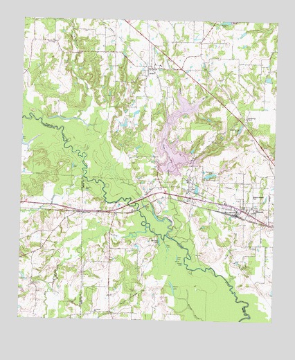
Golden, TX USGS Topographic Map
Click on map above to begin viewing in our Map Viewer.

This topographic map contains these locations and features:
Feature Name Type Latitude Longitude GNIS ID View Map
BenPopulated PlaceN32.6801°W95.5413°1377988View Map
Big L LakeReservoirN32.6886°W95.5257°1856089View Map
Big L Lake DamDamN32.6885°W95.5252°1856088View Map
Brittains LakeReservoirN32.7496°W95.5252°1856095View Map
Brushy LakeLakeN32.6790°W95.5925°1331451View Map
Butler LakeLakeN32.6666°W95.5554°1331750View Map
Camp LakeLakeN32.6512°W95.5473°1331982View Map
Cedar LakeLakeN32.7082°W95.6027°1332457View Map
Charter LakeLakeN32.6389°W95.5494°1332698View Map
Clear LakeLakeN32.6557°W95.5525°1332947View Map
Cottonwood ChurchChurchN32.7407°W95.6094°1333438View Map
Cottonwood CreekStreamN32.7082°W95.6155°1333473View Map
Dale Crest ChurchChurchN32.6396°W95.6191°1333882View Map
Dry CreekStreamN32.6640°W95.5613°1373469View Map
Frank Branch LibraryBuildingN32.6321°W95.5050°2014947View Map
GoldenPopulated PlaceN32.7296°W95.5630°1336649View Map
Golden Post OfficePost OfficeN32.7295°W95.5612°2731190View Map
Grand Saline CreekStreamN32.6849°W95.5944°1336804View Map
Grassy LakeLakeN32.6487°W95.5450°1336850View Map
Green and Ford CemeteryCemeteryN32.6726°W95.5161°1336904View Map
Henington - Alief Branch LibraryBuildingN32.6729°W95.5877°2014916View Map
Hillendahl Branch LibraryBuildingN32.6832°W95.5452°2014923View Map
Kendall Branch LibraryBuildingN32.7135°W95.6013°2014893View Map
Keys CreekStreamN32.6632°W95.5500°1339072View Map
Kim Juan Lake DamDamN32.6851°W95.5352°1856086View Map
Kim-Juan LakeReservoirN32.6856°W95.5324°1339112View Map
Lake HolbrookReservoirN32.6851°W95.5519°1856083View Map
Lankford CreekStreamN32.7126°W95.5458°1339627View Map
Lewis LakeLakeN32.6889°W95.5997°1339853View Map
Mineola Elementary SchoolSchoolN32.6699°W95.5008°2009257View Map
Mineola High SchoolSchoolN32.6699°W95.5008°2009258View Map
Mineola Wisener FieldAirportN32.6767°W95.5108°1387201View Map
Neil LakeLakeN32.6974°W95.6231°1342415View Map
Nolan-Edwards Oil FieldOilfieldN32.6962°W95.5380°1342649View Map
Northwest Branch LibraryBuildingN32.7379°W95.5900°2014838View Map
Plunk LakeReservoirN32.6451°W95.5936°1854840View Map
Plunk Lake DamDamN32.6451°W95.5936°1854839View Map
Providence SchoolSchoolN32.6276°W95.5875°1344606View Map
Sand Springs ChurchChurchN32.7096°W95.5147°1346543View Map
Sand Springs LakeReservoirN32.7053°W95.5176°1346544View Map
Schrivnor LakeLakeN32.6585°W95.5566°1346787View Map
Silver LakePopulated PlaceN32.6699°W95.5958°1379078View Map
Silver LakeLakeN32.6728°W95.5642°1347132View Map
Smith CreekStreamN32.6687°W95.5002°1347272View Map
Wellon CreekStreamN32.7126°W95.5458°1349639View Map
West MineolaPopulated PlaceN32.6715°W95.5191°1349763View Map
Wood County Dam Number 2DamN32.6851°W95.5519°1856082View Map

Note: Coordinates in the location and feature list above are referenced to NAD83 datum.


Copyright (C) 2008-2025 Ryan Niemi / Sunset Dynamics ... All Rights Reserved