TopoQuest Logo
Do you find TopoQuest useful?
Help keep TopoQuest running and adding new maps/features by donating!
Bitcoin:  19c7KJd3qBynnjoSw5npx9KScwjBe4ifkT
Litecoin:  LXs6TkuXGGXo1vDsWCkWVdjQX94eUKd6ui
Home View Maps Find Maps Find Places Resources & Links


Grand Saline, Texas Topographic Map

USGS Map Title: Grand Saline, TX
USGS Map MRC: 32095F6
DRG (GeoTIFF) Download: o32095f6.tif


Neighboring USGS Topographic Map Quads:


  Emory South, TX  
32095G7
 

  Alba, TX  
32095G6
 

  Calvary, TX  
32095G5
 

  Fruitvale, TX  
32095F7
 

  Grand Saline, TX  
32095F6
 

  Golden, TX  
32095F5
 

  Canton, TX  
32095E7
 

  Van, TX  
32095E6
 

  Van Lake, TX  
32095E5


Map MRC Location:

N33°
W96°
N33°
W95°
H8 H7 H6 H5 H4 H3 H2 H1
G8 G7 G6 G5 G4 G3 G2 G1
F8 F7 F6 F5 F4 F3 F2 F1
E8 E7 E6 E5 E4 E3 E2 E1
D8 D7 D6 D5 D4 D3 D2 D1
C8 C7 C6 C5 C4 C3 C2 C1
B8 B7 B6 B5 B4 B3 B2 B1
A8 A7 A6 A5 A4 A3 A2 A1
N32°
W96°
N32°
W95°

Grand Saline, TX USGS 1:24K Topographic Map Preview:
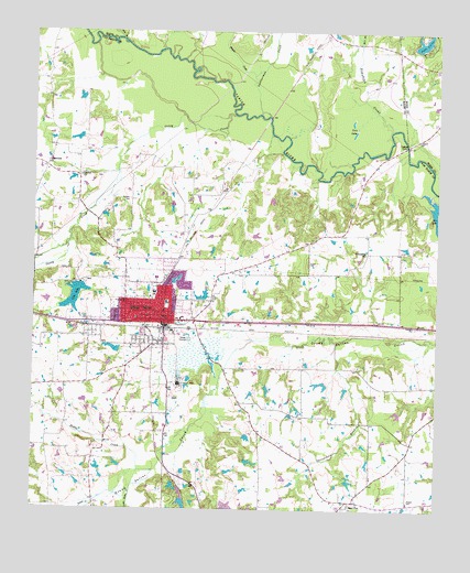
Grand Saline, TX USGS Topographic Map
Click on map above to begin viewing in our Map Viewer.

This topographic map contains these locations and features:
Feature Name Type Latitude Longitude GNIS ID View Map
Big LakeReservoirN32.6251°W95.6902°1859844View Map
Big Lake DamDamN32.6251°W95.6902°1859843View Map
Caney CreekStreamN32.7285°W95.6880°1332092View Map
Central ChurchChurchN32.7124°W95.7358°1332561View Map
Chrestman BranchStreamN32.6687°W95.6563°1332798View Map
City LakeReservoirN32.6808°W95.7375°1332865View Map
City of Grand SalineCivilN32.6775°W95.7113°2410633View Map
City of Grand Saline DamDamN32.6835°W95.7352°1859845View Map
Collins FerryLocaleN32.7210°W95.6350°1333119View Map
Cornerstone United Pentecostal ChurchChurchN32.6707°W95.7155°2024314View Map
Cozby Germany HospitalHospitalN32.6794°W95.7226°2015692View Map
Crossroads ChurchChurchN32.7151°W95.7461°1333730View Map
Darnell Dam Number 3DamN32.6318°W95.7052°1863748View Map
Darnell Dam Number 4DamN32.6285°W95.7036°1863750View Map
Darnell Lake Number 3ReservoirN32.6318°W95.7052°1863749View Map
Darnell Lake Number 4ReservoirN32.6295°W95.7039°1863751View Map
Davis BranchStreamN32.7479°W95.7236°1334081View Map
Dodds CreekStreamN32.6351°W95.7122°1334434View Map
First Pentecostal ChurchChurchN32.6707°W95.7155°2024315View Map
Franks CreekStreamN32.7387°W95.6825°1336163View Map
Friendship SchoolSchoolN32.6921°W95.6472°1336251View Map
Grand SalinePopulated PlaceN32.6735°W95.7094°1336803View Map
Grand Saline City HallBuildingN32.6733°W95.7088°2753785View Map
Grand Saline DivisionCivilN32.6615°W95.7214°1938801View Map
Grand Saline Elementary SchoolSchoolN32.6815°W95.7133°2008978View Map
Grand Saline Fire Department / Emergency Medical ServiceBuildingN32.6732°W95.7088°2655267View Map
Grand Saline High SchoolSchoolN32.6843°W95.7111°2008979View Map
Grand Saline Intermediate SchoolSchoolN32.6849°W95.7097°2008980View Map
Grand Saline Police DepartmentBuildingN32.6733°W95.7088°2751195View Map
Grand Saline Post OfficePost OfficeN32.6737°W95.7083°2732218View Map
Grnad Saline Middle SchoolSchoolN32.6849°W95.7097°2008981View Map
Jones LakeReservoirN32.6801°W95.6969°1862902View Map
Jones Lake DamDamN32.6801°W95.6969°1862901View Map
Koonce CreekStreamN32.6262°W95.7316°1339223View Map
Lake LouiseReservoirN32.7475°W95.6302°1340654View Map
Lake Louise DamDamN32.7451°W95.6319°1856084View Map
Leatherman CreekStreamN32.7279°W95.6777°1339763View Map
Little Saline CreekStreamN32.6307°W95.7191°1340176View Map
Main Street Baptist ChurchChurchN32.6746°W95.7094°2024365View Map
Maud Smith Marks Branch LibraryBuildingN32.7312°W95.7347°2014865View Map
Morton MineMineN32.6576°W95.7044°1341957View Map
Morton Salt Company DamDamN32.6668°W95.7236°1862606View Map
Morton Salt Company LakeReservoirN32.6667°W95.7241°1862607View Map
Number Five BranchStreamN32.7468°W95.6494°1342629View Map
Padgett CemeteryCemeteryN32.6270°W95.6331°1343409View Map
Rodgers CemeteryCemeteryN32.7060°W95.7205°1345510View Map
Sand FlatPopulated PlaceN32.6274°W95.6505°1379019View Map
Simpkins CreekStreamN32.7246°W95.6394°1347152View Map
Twin LakesLakeN32.7226°W95.6521°1348952View Map
Van Zandt County Constable's Office Precinct 1BuildingN32.6749°W95.7114°2751527View Map
Woodside CemeteryCemeteryN32.6801°W95.6933°1350566View Map

Note: Coordinates in the location and feature list above are referenced to NAD83 datum.


Copyright (C) 2008-2025 Ryan Niemi / Sunset Dynamics ... All Rights Reserved