TopoQuest Logo
Do you find TopoQuest useful?
Help keep TopoQuest running and adding new maps/features by donating!
Bitcoin:  19c7KJd3qBynnjoSw5npx9KScwjBe4ifkT
Litecoin:  LXs6TkuXGGXo1vDsWCkWVdjQX94eUKd6ui
Home View Maps Find Maps Find Places Resources & Links


Calvary, Texas Topographic Map

USGS Map Title: Calvary, TX
USGS Map MRC: 32095G5
DRG (GeoTIFF) Download: o32095g5.tif


Neighboring USGS Topographic Map Quads:


  Arbala, TX  
32095H6
 

  Yantis, TX  
32095H5
 

  Pleasant Grove, TX  
32095H4
 

  Alba, TX  
32095G6
 

  Calvary, TX  
32095G5
 

  Quitman, TX  
32095G4
 

  Grand Saline, TX  
32095F6
 

  Golden, TX  
32095F5
 

  Mineola, TX  
32095F4


Map MRC Location:

N33°
W96°
N33°
W95°
H8 H7 H6 H5 H4 H3 H2 H1
G8 G7 G6 G5 G4 G3 G2 G1
F8 F7 F6 F5 F4 F3 F2 F1
E8 E7 E6 E5 E4 E3 E2 E1
D8 D7 D6 D5 D4 D3 D2 D1
C8 C7 C6 C5 C4 C3 C2 C1
B8 B7 B6 B5 B4 B3 B2 B1
A8 A7 A6 A5 A4 A3 A2 A1
N32°
W96°
N32°
W95°

Calvary, TX USGS 1:24K Topographic Map Preview:
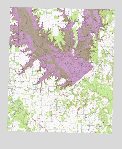
Calvary, TX USGS Topographic Map
Click on map above to begin viewing in our Map Viewer.

This topographic map contains these locations and features:
Feature Name Type Latitude Longitude GNIS ID View Map
Alba DivisionCivilN32.7757°W95.5885°1938480View Map
Alba Oil FieldOilfieldN32.7901°W95.6188°1329325View Map
Alum BranchStreamN32.7921°W95.5216°1329470View Map
Bell BranchStreamN32.8737°W95.5263°1372486View Map
Brittain Lake DamDamN32.7501°W95.5236°1856094View Map
CalvaryPopulated PlaceN32.7579°W95.5272°1378086View Map
Calvary ChurchChurchN32.7579°W95.5230°1331916View Map
Caney CreekStreamN32.8087°W95.5433°1372924View Map
Case LakeReservoirN32.8350°W95.6148°1855211View Map
Champion LakeReservoirN32.7568°W95.5146°1332639View Map
Chaney BranchStreamN32.8073°W95.5438°1332647View Map
Clark BranchStreamN32.7887°W95.5150°1332879View Map
Dale CreekStreamN32.8207°W95.5594°1333881View Map
Enon ChurchChurchN32.7932°W95.6002°1335479View Map
Fly 1 On AirportAirportN32.7574°W95.5231°2676602View Map
Hayes LakeReservoirN32.7666°W95.5332°1337495View Map
Hayes Lake DamDamN32.7685°W95.5319°1856126View Map
Kendall LakeReservoirN32.7680°W95.5208°1856093View Map
Kindle Lake DamDamN32.7701°W95.5202°1856092View Map
KMOO-FM (Mineola)TowerN32.7512°W95.5552°1385943View Map
Lake Fork DamDamN32.7768°W95.5002°1862875View Map
Lake Fork ReservoirReservoirN32.8043°W95.5394°1388620View Map
Lands End Volunteer Fire DepartmentBuildingN32.8467°W95.5742°2655687View Map
Little Caney CreekStreamN32.8187°W95.5558°1340044View Map
Little Mustang CreekStreamN32.8451°W95.6002°1340143View Map
Mustang CreekStreamN32.8512°W95.6044°1342316View Map
Pilgrims Rest Number 2 ChurchChurchN32.7543°W95.5802°1344009View Map
Pleasant Divide ChurchChurchN32.8601°W95.5350°1344182View Map
Pleasant Ridge ChurchChurchN32.7929°W95.5852°1344239View Map
Rainwater CreekStreamN32.8018°W95.5297°1375616View Map
Ray BranchStreamN32.8179°W95.5641°1344843View Map
Ring Branch LibraryBuildingN32.7565°W95.5086°2014803View Map
Robinson - Westchase Branch LibraryBuildingN32.7607°W95.5722°2014807View Map
SalemPopulated PlaceN32.8254°W95.6188°1379010View Map
Searcy BranchStreamN32.8571°W95.5275°1376055View Map
Searcy CemeteryCemeteryN32.8465°W95.5050°1346852View Map
Spring Branch LibraryBuildingN32.7762°W95.5130°2014777View Map
Taylor BranchStreamN32.8596°W95.5236°1348283View Map
Taylor LakeReservoirN32.7957°W95.5927°1348294View Map
The Links at Land's EndLocaleN32.8453°W95.5731°2572398View Map
Tomball Branch LibraryBuildingN32.7810°W95.6183°2014738View Map
Walter Branch LibraryBuildingN32.8004°W95.5200°2014749View Map
Williams CreekStreamN32.8462°W95.6030°1350138View Map
Wolf BranchStreamN32.8362°W95.5863°1350454View Map

Note: Coordinates in the location and feature list above are referenced to NAD83 datum.


Copyright (C) 2008-2024 Ryan Niemi / Sunset Dynamics ... All Rights Reserved