TopoQuest Logo
Do you find TopoQuest useful?
Help keep TopoQuest running and adding new maps/features by donating!
Bitcoin:  19c7KJd3qBynnjoSw5npx9KScwjBe4ifkT
Litecoin:  LXs6TkuXGGXo1vDsWCkWVdjQX94eUKd6ui
Home View Maps Find Maps Find Places Resources & Links


Goodman, Alabama Topographic Map

USGS Map Title: Goodman, AL
USGS Map MRC: 31085C8
DRG (GeoTIFF) Download: o31085c8.tif


Neighboring USGS Topographic Map Quads:


  Elba, AL  
31086D1
 

  New Brockton, AL  
31085D8
 

  Enterprise NE, AL  
31085D7
 

  Ino, AL  
31086C1
 

  Goodman, AL  
31085C8
 

  Enterprise, AL  
31085C7
 

  Sellersville, AL  
31086B1
 

  Coffee Springs, AL  
31085B8
 

  Bellwood, AL  
31085B7


Map MRC Location:

N32°
W86°
N32°
W85°
H8 H7 H6 H5 H4 H3 H2 H1
G8 G7 G6 G5 G4 G3 G2 G1
F8 F7 F6 F5 F4 F3 F2 F1
E8 E7 E6 E5 E4 E3 E2 E1
D8 D7 D6 D5 D4 D3 D2 D1
C8 C7 C6 C5 C4 C3 C2 C1
B8 B7 B6 B5 B4 B3 B2 B1
A8 A7 A6 A5 A4 A3 A2 A1
N31°
W86°
N31°
W85°

Goodman, AL USGS 1:24K Topographic Map Preview:
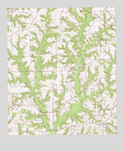
Goodman, AL USGS Topographic Map
Click on map above to begin viewing in our Map Viewer.

This topographic map contains these locations and features:
Feature Name Type Latitude Longitude GNIS ID View Map
Asbury CemeteryCemeteryN31.2543°W85.9791°137056View Map
Asbury Methodist ChurchChurchN31.2535°W85.9791°113241View Map
Battens ChurchChurchN31.2618°W85.8902°135294View Map
Battens CrossroadsPopulated PlaceN31.2610°W85.8899°113572View Map
Battens Volunteer Fire DepartmentBuildingN31.2601°W85.8923°2691235View Map
Bear BranchStreamN31.2688°W85.9583°135295View Map
Bethany Baptist ChurchChurchN31.3416°W85.9449°113990View Map
Bethany CemeteryCemeteryN31.3410°W85.9430°137058View Map
Blanket CreekStreamN31.2849°W85.9158°114484View Map
Boggy BranchStreamN31.3057°W85.9641°135300View Map
Byrds Mill (historical)LocaleN31.3699°W85.9016°135307View Map
Calvary Baptist ChurchChurchN31.3718°W85.8866°115405View Map
Calvary CemeteryCemeteryN31.3718°W85.8849°137061View Map
Enterprise Municipal AirportAirportN31.2979°W85.9001°129393View Map
Fairfield EstatesPopulated PlaceN31.3249°W85.8822°155753View Map
GoodmanPopulated PlaceN31.2796°W85.9936°119143View Map
Goodman CemeteryCemeteryN31.2791°W85.9944°137076View Map
Goodman ChurchChurchN31.2910°W85.9947°119144View Map
Goodman Junior High SchoolSchoolN31.2821°W85.9944°135339View Map
Goodman Missionary Baptist ChurchChurchN31.2793°W85.9936°135338View Map
Goodman Volunteer Fire DepartmentBuildingN31.2655°W85.9826°2691124View Map
Harp School (historical)SchoolN31.3388°W85.9733°135343View Map
John Moates Lake DamDamN31.3368°W85.8766°129772View Map
Kelly BranchStreamN31.3660°W85.9927°135361View Map
Kelly CemeteryCemeteryN31.3718°W85.9772°135362View Map
Little Double Bridges CreekStreamN31.2510°W85.9491°121778View Map
Long BranchStreamN31.2774°W85.9194°135373View Map
Longbranch CreekStreamN31.3296°W85.9158°122019View Map
Love's Way ChurchChurchN31.3232°W85.9024°2580205View Map
Martin Spring BranchStreamN31.3529°W85.9163°135376View Map
Meadow Lawn Memorial ParkParkN31.2752°W85.8799°122616View Map
Moates LakeReservoirN31.3368°W85.8766°129773View Map
Monroe Mynard PondReservoirN31.2535°W85.9133°129737View Map
Monroe Mynard Pond DamDamN31.2535°W85.9133°129738View Map
Mornin Star ChurchChurchN31.2932°W85.9316°123056View Map
Morning Star CemeteryCemeteryN31.2932°W85.9313°157722View Map
Mount Calvary CemeteryCemeteryN31.3504°W85.9910°123149View Map
Mount Calvary Missionary Baptist ChurchChurchN31.3633°W85.9942°149982View Map
New Canaan Church (historical)ChurchN31.3141°W85.9944°135388View Map
New Home Baptist ChurchChurchN31.2949°W85.9483°149991View Map
New Home BranchStreamN31.2646°W85.9413°152628View Map
New Home CemeteryCemeteryN31.2738°W85.9397°135389View Map
New Home Church (historical)ChurchN31.2738°W85.9399°150034View Map
Peacock Mill BranchStreamN31.2907°W85.9708°135396View Map
Pine ForestPopulated PlaceN31.3071°W85.8808°155773View Map
Pleasant Ridge CemeteryCemeteryN31.3016°W85.9324°137092View Map
Pleasant Ridge Methodist ChurchChurchN31.3018°W85.9330°153008View Map
Pleasant Shade Baptist ChurchChurchN31.3235°W85.8888°150004View Map
Roberts BranchStreamN31.3049°W85.9797°135411View Map
Rocky BranchStreamN31.2613°W85.9558°135412View Map
Saint Mary Baptist ChurchChurchN31.3427°W85.8783°150015View Map
Spring BranchStreamN31.2877°W85.9122°135427View Map
Stenson School (historical)SchoolN31.2577°W85.9236°135428View Map
Turner CrossroadsPopulated PlaceN31.3124°W85.9741°157179View Map
Union AcademySchoolN31.2604°W85.9083°135437View Map
Union School (historical)SchoolN31.3449°W85.9952°135438View Map
Watson School (historical)SchoolN31.3235°W85.8941°135441View Map
Wilbers CreekStreamN31.2954°W85.9719°128948View Map
Wooten ChapelChurchN31.3532°W85.9819°129233View Map

Note: Coordinates in the location and feature list above are referenced to NAD83 datum.


Copyright (C) 2008-2025 Ryan Niemi / Sunset Dynamics ... All Rights Reserved