TopoQuest Logo
Do you find TopoQuest useful?
Help keep TopoQuest running and adding new maps/features by donating!
Bitcoin:  19c7KJd3qBynnjoSw5npx9KScwjBe4ifkT
Litecoin:  LXs6TkuXGGXo1vDsWCkWVdjQX94eUKd6ui
Home View Maps Find Maps Find Places Resources & Links


Sellersville, Alabama Topographic Map

USGS Map Title: Sellersville, AL
USGS Map MRC: 31086B1
DRG (GeoTIFF) Download: o31086b1.tif


Neighboring USGS Topographic Map Quads:


  Opp East, AL  
31086C2
 

  Ino, AL  
31086C1
 

  Goodman, AL  
31085C8
 

  Kinston, AL  
31086B2
 

  Sellersville, AL  
31086B1
 

  Coffee Springs, AL  
31085B8
 

  Hacoda, AL  
31086A2
 

  Samson, AL  
31086A1
 

  Geneva West, AL  
31085A8


Map MRC Location:

N32°
W87°
N32°
W86°
H8 H7 H6 H5 H4 H3 H2 H1
G8 G7 G6 G5 G4 G3 G2 G1
F8 F7 F6 F5 F4 F3 F2 F1
E8 E7 E6 E5 E4 E3 E2 E1
D8 D7 D6 D5 D4 D3 D2 D1
C8 C7 C6 C5 C4 C3 C2 C1
B8 B7 B6 B5 B4 B3 B2 B1
A8 A7 A6 A5 A4 A3 A2 A1
N31°
W87°
N31°
W86°

Sellersville, AL USGS 1:24K Topographic Map Preview:
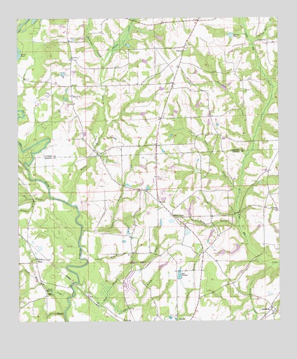
Sellersville, AL USGS Topographic Map
Click on map above to begin viewing in our Map Viewer.

This topographic map contains these locations and features:
Feature Name Type Latitude Longitude GNIS ID View Map
Bear BranchStreamN31.1771°W86.1099°113639View Map
Beaverdam BranchStreamN31.2299°W86.0833°113754View Map
Beaverdam CreekStreamN31.1980°W86.0119°113758View Map
Bee BranchStreamN31.1338°W86.0830°113791View Map
Bowden Sessions Pond DamDamN31.2452°W86.0216°129736View Map
Bowdens Store (historical)LocaleN31.2432°W86.0413°135301View Map
Brewton ChurchChurchN31.1793°W86.0538°163133View Map
Cedar BranchStreamN31.1282°W86.1033°115735View Map
Crews CemeteryCemeteryN31.1635°W86.0833°158330View Map
E S Brooks DamDamN31.1418°W86.0483°129665View Map
Elton ChurchChurchN31.1360°W86.1119°117968View Map
FairviewPopulated PlaceN31.2382°W86.0444°156333View Map
Fairview Baptist ChurchChurchN31.2382°W86.0447°135329View Map
Fairview CemeteryCemeteryN31.2377°W86.0444°137070View Map
Fairview SchoolSchoolN31.2374°W86.0455°135330View Map
Faulk Mill CreekStreamN31.1355°W86.1005°118216View Map
Faulk MillpondLakeN31.1375°W86.1090°118217View Map
Frank Davis DamDamN31.1918°W86.0116°129693View Map
Frank Davis LakeReservoirN31.1918°W86.0116°129694View Map
Fred Denman LakeReservoirN31.1624°W86.0010°129680View Map
Friendship Baptist ChurchChurchN31.2338°W86.0991°149963View Map
Friendship CemeteryCemeteryN31.2338°W86.0999°137071View Map
Haney CemeteryCemeteryN31.2246°W86.0144°119676View Map
Holley BranchStreamN31.1641°W86.0188°120245View Map
Holley Mill CreekStreamN31.1735°W86.0997°120249View Map
Holley StorePopulated PlaceN31.2224°W86.0991°1699932View Map
James Wise PondReservoirN31.2135°W86.0666°129706View Map
James Wise Pond Dam Number 1DamN31.2135°W86.0666°129707View Map
James Wise Pond Dam Number 2DamN31.2252°W86.0333°129722View Map
James Wise Pond Number TwoReservoirN31.2252°W86.0333°129721View Map
Lake FrankieReservoirN31.1440°W86.0479°118594View Map
LeverettLocaleN31.2491°W86.0380°135371View Map
Little Rocky CreekStreamN31.1621°W86.0947°121873View Map
Lowery CreekStreamN31.1757°W86.1208°143021View Map
Macedonia CemeteryCemeteryN31.2185°W86.0986°135374View Map
Macedonia Primitive Baptist ChurchChurchN31.2179°W86.0986°149976View Map
Mount CarmelPopulated PlaceN31.1707°W86.0011°1730343View Map
Mount Carmel ChurchChurchN31.1710°W86.0008°123168View Map
Mount Carmel SchoolSchoolN31.1707°W86.0005°132159View Map
Mount Olive Baptist ChurchChurchN31.2199°W86.0155°149984View Map
Mount Olive CemeteryCemeteryN31.1954°W86.0583°135382View Map
Palmer BranchStreamN31.1791°W86.0188°124387View Map
PeraPopulated PlaceN31.1355°W86.0919°156871View Map
Phillips CreekStreamN31.2299°W86.0833°124687View Map
Phillips Mill BranchStreamN31.2402°W86.0124°112868View Map
Piney GrovePopulated PlaceN31.1688°W86.0508°156900View Map
Piney Grove CemeteryCemeteryN31.1688°W86.0519°1730177View Map
Piney Grove ChurchChurchN31.1635°W86.0449°158969View Map
Piney Grove ChurchChurchN31.2407°W86.0088°124874View Map
Piney Grove ChurchChurchN31.1685°W86.0516°132169View Map
Piney Grove ChurchChurchN31.1652°W86.0449°158336View Map
Pond BranchStreamN31.2377°W86.0705°135403View Map
Red Bug SchoolSchoolN31.1907°W86.0838°132176View Map
Roland Day PondReservoirN31.2168°W86.0216°129710View Map
Roland Day Pond DamDamN31.2168°W86.0216°129711View Map
Roundabout CreekStreamN31.1488°W86.0019°125985View Map
Sellers Store (historical)LocaleN31.1466°W86.0661°132184View Map
SellersvillePopulated PlaceN31.1299°W86.0041°126541View Map
Sellersville ChurchChurchN31.1324°W86.0036°132185View Map
Sessions PondReservoirN31.2430°W86.0225°126556View Map
Snake BranchStreamN31.1557°W86.0949°127063View Map
Soapstone BranchStreamN31.1757°W86.1169°127087View Map
Spivey Camp GroundLocaleN31.1371°W86.1111°158337View Map
Spivey TabernacleChurchN31.1368°W86.1108°127192View Map
Ted Averett DamDamN31.1685°W86.0433°129687View Map
Ted Averett LakeReservoirN31.1712°W86.0426°158111View Map
Tiger BranchStreamN31.1410°W86.0961°127973View Map
Underwood MillLocaleN31.1693°W86.0205°132195View Map
WeeksPopulated PlaceN31.1507°W86.1163°128697View Map
Weeks CemeteryCemeteryN31.2182°W86.1097°137101View Map
Weeks Chapel ChurchChurchN31.1510°W86.1161°132202View Map
Weeks ChurchChurchN31.2191°W86.1094°153916View Map
Weeks Memorial ChurchChurchN31.1516°W86.1172°158339View Map
Weeks SchoolSchoolN31.1516°W86.1172°132203View Map
Whisky BranchStreamN31.2213°W86.0022°128850View Map

Note: Coordinates in the location and feature list above are referenced to NAD83 datum.


Copyright (C) 2008-2024 Ryan Niemi / Sunset Dynamics ... All Rights Reserved