TopoQuest Logo
Do you find TopoQuest useful?
Help keep TopoQuest running and adding new maps/features by donating!
Bitcoin:  19c7KJd3qBynnjoSw5npx9KScwjBe4ifkT
Litecoin:  LXs6TkuXGGXo1vDsWCkWVdjQX94eUKd6ui
Home View Maps Find Maps Find Places Resources & Links


New Brockton, Alabama Topographic Map

USGS Map Title: New Brockton, AL
USGS Map MRC: 31085D8
DRG (GeoTIFF) Download: o31085d8.tif


Neighboring USGS Topographic Map Quads:


  Bluff Springs, AL  
31086E1
 

  Victoria, AL  
31085E8
 

  Brundidge SE, AL  
31085E7
 

  Elba, AL  
31086D1
 

  New Brockton, AL  
31085D8
 

  Enterprise NE, AL  
31085D7
 

  Ino, AL  
31086C1
 

  Goodman, AL  
31085C8
 

  Enterprise, AL  
31085C7


Map MRC Location:

N32°
W86°
N32°
W85°
H8 H7 H6 H5 H4 H3 H2 H1
G8 G7 G6 G5 G4 G3 G2 G1
F8 F7 F6 F5 F4 F3 F2 F1
E8 E7 E6 E5 E4 E3 E2 E1
D8 D7 D6 D5 D4 D3 D2 D1
C8 C7 C6 C5 C4 C3 C2 C1
B8 B7 B6 B5 B4 B3 B2 B1
A8 A7 A6 A5 A4 A3 A2 A1
N31°
W86°
N31°
W85°

New Brockton, AL USGS 1:24K Topographic Map Preview:
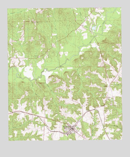
New Brockton, AL USGS Topographic Map
Click on map above to begin viewing in our Map Viewer.

This topographic map contains these locations and features:
Feature Name Type Latitude Longitude GNIS ID View Map
Arwood School (historical)SchoolN31.4168°W85.9599°135290View Map
Athens Church (historical)ChurchN31.4793°W85.9330°135291View Map
Camp Humming HillsLocaleN31.4682°W85.9986°135312View Map
Cardwell CreekStreamN31.4752°W85.9033°115615View Map
ClintonvillePopulated PlaceN31.4071°W85.8941°116274View Map
Clintonville Baptist ChurchChurchN31.4143°W85.8913°149942View Map
Coffee CountyCivilN31.4026°W85.9882°161541View Map
Coffee County Sheriff's OfficeBuildingN31.3772°W85.9158°2752008View Map
Collins ChapelChurchN31.3874°W85.9347°116443View Map
Coopers CreekStreamN31.4316°W85.9752°116592View Map
Ellis Mill CreekStreamN31.4429°W85.9983°135325View Map
Folsom BridgeBridgeN31.4727°W85.9049°149960View Map
Folsome Mill CreekStreamN31.4854°W85.8936°154505View Map
Greater Holy Temple ChurchChurchN31.4071°W85.8816°135435View Map
Harpers Mill CreekStreamN31.4371°W85.9641°119775View Map
Hollis PondReservoirN31.4091°W85.8869°129808View Map
Hollis Pond DamDamN31.4085°W85.8866°129809View Map
Hutchson and Russell Family CemeteryCemeteryN31.4527°W85.9147°135353View Map
Indigo CreekStreamN31.4477°W85.9386°120674View Map
Johnson CreekStreamN31.4474°W85.9999°135358View Map
Kingdom Hall ChurchChurchN31.3957°W85.9669°135366View Map
Lake Nolin DamDamN31.4791°W85.9053°129854View Map
Marsh BranchStreamN31.4093°W85.9474°135375View Map
McGee CemeteryCemeteryN31.4210°W85.9313°122541View Map
McGees BranchStreamN31.4246°W85.9544°135377View Map
Meadow BranchStreamN31.4418°W85.9224°135378View Map
MixsonPopulated PlaceN31.4829°W85.9194°135380View Map
Mount Pleasant CemeteryCemeteryN31.4243°W85.8922°137080View Map
Mount Pleasant Primitive Baptist ChurchChurchN31.4246°W85.8913°119725View Map
Mount Zion Baptist ChurchChurchN31.4824°W85.9172°150032View Map
Mount Zion CemeteryCemeteryN31.4827°W85.9188°123419View Map
New BrocktonPopulated PlaceN31.3857°W85.9294°152611View Map
New Brockton City CemeteryCemeteryN31.3868°W85.9269°137084View Map
New Brockton High SchoolSchoolN31.3860°W85.9361°135387View Map
New Brockton Police DepartmentBuildingN31.3852°W85.9305°2751756View Map
New Brockton Post OfficePost OfficeN31.3838°W85.9312°167520View Map
New Brockton United Methodist ChurchChurchN31.3855°W85.9271°157645View Map
New Brockton Volunteer Fire DepartmentBuildingN31.3843°W85.9333°2691249View Map
Newhope Church (historical)ChurchN31.4518°W85.9761°135393View Map
Nolin LakeReservoirN31.4810°W85.9049°135395View Map
Pathway Juvenile Wilderness CampLocaleN31.4260°W85.9027°1699936View Map
Pine Grove Church (historical)ChurchN31.4716°W85.9822°135398View Map
Pleasant Ridge CemeteryCemeteryN31.4877°W85.9708°137091View Map
Pleasant Ridge Primitive Baptist ChurchChurchN31.4874°W85.9708°150003View Map
Popular Springs Baptist ChurchChurchN31.4029°W85.9141°150005View Map
Red Oak CreekStreamN31.4443°W85.9469°125492View Map
RichburgPopulated PlaceN31.3968°W85.9608°156964View Map
Roe BridgeBridgeN31.4454°W85.9430°125890View Map
Sawyer LakeReservoirN31.4347°W85.9124°129828View Map
Sawyer Lake DamDamN31.4335°W85.9133°129827View Map
School House BranchStreamN31.3874°W85.9955°135417View Map
Shiloh ChurchChurchN31.4021°W85.9955°126726View Map
Shiloh SchoolSchoolN31.4027°W85.9955°135421View Map
Tindle CreekStreamN31.4957°W85.8855°135434View Map
Town of New BrocktonCivilN31.3784°W85.9228°2406973View Map
Weeks BridgeBridgeN31.4327°W85.9697°128699View Map
WKMX-FM (Enterprise)TowerN31.4127°W85.9588°161134View Map
Woodland CemeteryCemeteryN31.4543°W85.9663°137105View Map
Woodland Grove Baptist ChurchChurchN31.4546°W85.9666°154025View Map

Note: Coordinates in the location and feature list above are referenced to NAD83 datum.


Copyright (C) 2008-2025 Ryan Niemi / Sunset Dynamics ... All Rights Reserved