TopoQuest Logo
Do you find TopoQuest useful?
Help keep TopoQuest running and adding new maps/features by donating!
Bitcoin:  19c7KJd3qBynnjoSw5npx9KScwjBe4ifkT
Litecoin:  LXs6TkuXGGXo1vDsWCkWVdjQX94eUKd6ui
Home View Maps Find Maps Find Places Resources & Links


Gorman, Maryland Topographic Map

USGS Map Title: Gorman, MD
USGS Map MRC: 39079C3
DRG (GeoTIFF) Download: o39079c3.tif


Neighboring USGS Topographic Map Quads:


  Oakland, MD  
39079D4
 

  Deer Park, MD  
39079D3
 

  Kitzmiller, MD  
39079D2
 

  Table Rock, MD  
39079C4
 

  Gorman, MD  
39079C3
 

  Mount Storm, WV  
39079C2
 

  Davis, WV  
39079B4
 

  Mount Storm Lake, WV  
39079B3
 

  Greenland Gap, WV  
39079B2


Map MRC Location:

N40°
W80°
N40°
W79°
H8 H7 H6 H5 H4 H3 H2 H1
G8 G7 G6 G5 G4 G3 G2 G1
F8 F7 F6 F5 F4 F3 F2 F1
E8 E7 E6 E5 E4 E3 E2 E1
D8 D7 D6 D5 D4 D3 D2 D1
C8 C7 C6 C5 C4 C3 C2 C1
B8 B7 B6 B5 B4 B3 B2 B1
A8 A7 A6 A5 A4 A3 A2 A1
N39°
W80°
N39°
W79°

Gorman, MD USGS 1:24K Topographic Map Preview:
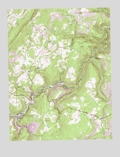
Gorman, MD USGS Topographic Map
Click on map above to begin viewing in our Map Viewer.

This topographic map contains these locations and features:
Feature Name Type Latitude Longitude GNIS ID View Map
BayardPopulated PlaceN39.2729°W79.3645°1553813View Map
Bayard CemeteryCemeteryN39.2729°W79.3445°1535319View Map
Bayard Post OfficePost OfficeN39.2731°W79.3664°1697219View Map
Bayard Truss BridgeBridgeN39.2739°W79.3697°2635408View Map
Bayard Volunteer Fire DepartmentBuildingN39.2717°W79.3647°2577794View Map
Berrett (historical)Populated PlaceN39.2854°W79.3512°1711120View Map
Bethlehem ChurchChurchN39.3687°W79.2970°583193View Map
Bethlehem SchoolSchoolN39.3704°W79.2859°583194View Map
Bradshaw (historical)Populated PlaceN39.3273°W79.2759°1711128View Map
Buffalo CreekStreamN39.2745°W79.3645°1536636View Map
Chisholm-Nydegger CemeteryCemeteryN39.3190°W79.3400°583764View Map
Crooked RunStreamN39.3543°W79.2564°583977View Map
Dales SpringSpringN39.2926°W79.3248°1677864View Map
Difficult CreekStreamN39.2987°W79.2925°1538185View Map
Difficult HillSummitN39.2873°W79.3212°1538186View Map
District 16, Mountain Lake ParkCivilN39.3718°W79.3510°1929503View Map
Fort PendletonPopulated PlaceN39.2954°W79.3742°590228View Map
Glade RunStreamN39.3012°W79.3253°584604View Map
GormanPopulated PlaceN39.2954°W79.3464°590346View Map
Gorman Census Designated PlaceCensusN39.2927°W79.3527°2583633View Map
Gorman Volunteer Fire Department Station 120BuildingN39.2967°W79.3470°1953584View Map
GormaniaPopulated PlaceN39.2929°W79.3445°1554585View Map
Gormania BridgeBridgeN39.2932°W79.3470°1711139View Map
Gormania Post OfficePost OfficeN39.2926°W79.3456°1697237View Map
Harvey-Wilson CemeteryCemeteryN39.3326°W79.3112°584893View Map
KearneyPopulated PlaceN39.3432°W79.3223°590579View Map
Kelso GapGapN39.3643°W79.3453°585290View Map
Laurel RunStreamN39.3429°W79.2575°585373View Map
Lish CemeteryCemeteryN39.3348°W79.3559°585432View Map
Little Buffalo CreekStreamN39.2626°W79.3625°1542046View Map
Little Buffalo Creek - North Branch DamDamN39.2601°W79.3514°1557459View Map
Little Yok Reservoir Site Number 5ReservoirN39.3736°W79.3742°594319View Map
Mill RunStreamN39.2607°W79.2595°1543352View Map
Moreland CemeteryCemeteryN39.2954°W79.3700°585960View Map
North Prong Lostland RunStreamN39.3715°W79.2545°586245View Map
Nydegger RunStreamN39.2937°W79.3453°586264View Map
Oak Grove CemeteryCemeteryN39.3148°W79.3528°586266View Map
Oak Grove ChurchChurchN39.3159°W79.3470°586268View Map
Potomac State ForestForestN39.3401°W79.2800°586689View Map
Rileys Spring BranchStreamN39.3473°W79.2942°586837View Map
SchellPopulated PlaceN39.3420°W79.2598°591237View Map
SchellLocaleN39.3420°W79.2570°1555582View Map
South Prong Lostland RunStreamN39.3715°W79.2545°587468View Map
SteyerPopulated PlaceN39.3057°W79.3109°587554View Map
Steyer RunStreamN39.3045°W79.3120°587555View Map
Stony RiverStreamN39.3276°W79.2717°1553080View Map
Tasker CornersLocaleN39.3623°W79.2942°587703View Map
Town of BayardCivilN39.2711°W79.3662°2390716View Map
Trout RunStreamN39.3484°W79.2900°587888View Map
Union Educational ComplexSchoolN39.2744°W79.2799°1697279View Map
WallmanPopulated PlaceN39.3170°W79.2839°591484View Map
White CemeteryCemeteryN39.3559°W79.3273°588195View Map
White CemeteryCemeteryN39.3426°W79.3195°1711179View Map
White ChurchChurchN39.3434°W79.3220°588196View Map

Note: Coordinates in the location and feature list above are referenced to NAD83 datum.


Copyright (C) 2008-2025 Ryan Niemi / Sunset Dynamics ... All Rights Reserved