TopoQuest Logo
Do you find TopoQuest useful?
Help keep TopoQuest running and adding new maps/features by donating!
Bitcoin:  19c7KJd3qBynnjoSw5npx9KScwjBe4ifkT
Litecoin:  LXs6TkuXGGXo1vDsWCkWVdjQX94eUKd6ui
Home View Maps Find Maps Find Places Resources & Links


Mount Storm Lake, West Virginia Topographic Map

USGS Map Title: Mount Storm Lake, WV
USGS Map MRC: 39079B3
DRG (GeoTIFF) Download: o39079b3.tif


Neighboring USGS Topographic Map Quads:


  Table Rock, MD  
39079C4
 

  Gorman, MD  
39079C3
 

  Mount Storm, WV  
39079C2
 

  Davis, WV  
39079B4
 

  Mount Storm Lake, WV  
39079B3
 

  Greenland Gap, WV  
39079B2
 

  Blackwater Falls, WV  
39079A4
 

  Blackbird Knob, WV  
39079A3
 

  Maysville, WV  
39079A2


Map MRC Location:

N40°
W80°
N40°
W79°
H8 H7 H6 H5 H4 H3 H2 H1
G8 G7 G6 G5 G4 G3 G2 G1
F8 F7 F6 F5 F4 F3 F2 F1
E8 E7 E6 E5 E4 E3 E2 E1
D8 D7 D6 D5 D4 D3 D2 D1
C8 C7 C6 C5 C4 C3 C2 C1
B8 B7 B6 B5 B4 B3 B2 B1
A8 A7 A6 A5 A4 A3 A2 A1
N39°
W80°
N39°
W79°

Mount Storm Lake, WV USGS 1:24K Topographic Map Preview:
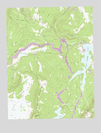
Mount Storm Lake, WV USGS Topographic Map
Click on map above to begin viewing in our Map Viewer.

This topographic map contains these locations and features:
Feature Name Type Latitude Longitude GNIS ID View Map
Accident School (historical)SchoolN39.2359°W79.2603°1697215View Map
Brown MountainSummitN39.1629°W79.3728°1550484View Map
Camp 94 (historical)LocaleN39.1348°W79.2873°1697225View Map
Camp SeventytwoLocaleN39.1440°W79.3498°1536962View Map
Canaan ValleyValleyN39.1755°W79.3427°1550627View Map
Cherry RidgeRidgeN39.2312°W79.3184°1537245View Map
Dobbin RidgeRidgeN39.1996°W79.3642°1550932View Map
Elder SwampSwampN39.1994°W79.3495°1538588View Map
Fourmile RunStreamN39.2190°W79.2959°1539186View Map
Helmick RunStreamN39.1568°W79.2653°1540132View Map
Ice House RocksAreaN39.1815°W79.3464°1689370View Map
Laurel RunStreamN39.2279°W79.3048°1541517View Map
Morgan RunStreamN39.1729°W79.2803°1543548View Map
Mount Storm LakeReservoirN39.1876°W79.2607°1543767View Map
Mount Storm Power StationBuildingN39.2008°W79.2628°2560322View Map
Mount Storm Power Station Fire Department and RescueBuildingN39.2026°W79.2636°2775499View Map
Mud RunStreamN39.1434°W79.2881°1543916View Map
Red Brush RidgeRidgeN39.2059°W79.3281°1545446View Map
Red Sea RunStreamN39.1646°W79.2867°1545463View Map
Snowy PointSummitN39.1637°W79.3225°1547041View Map
Stony River DamDamN39.1373°W79.2982°1557455View Map
Stony River DamDamN39.1373°W79.2987°1547497View Map
Stony River ReservoirReservoirN39.1254°W79.3050°1550384View Map
Timberman RidgeRidgeN39.1948°W79.3703°1548098View Map
Union DistrictCivilN39.1512°W79.2593°1928385View Map

Note: Coordinates in the location and feature list above are referenced to NAD83 datum.


Copyright (C) 2008-2025 Ryan Niemi / Sunset Dynamics ... All Rights Reserved