TopoQuest Logo
Do you find TopoQuest useful?
Help keep TopoQuest running and adding new maps/features by donating!
Bitcoin:  19c7KJd3qBynnjoSw5npx9KScwjBe4ifkT
Litecoin:  LXs6TkuXGGXo1vDsWCkWVdjQX94eUKd6ui
Home View Maps Find Maps Find Places Resources & Links


Mount Storm, West Virginia Topographic Map

USGS Map Title: Mount Storm, WV
USGS Map MRC: 39079C2
DRG (GeoTIFF) Download: o39079c2.tif


Neighboring USGS Topographic Map Quads:


  Deer Park, MD  
39079D3
 

  Kitzmiller, MD  
39079D2
 

  Westernport, MD  
39079D1
 

  Gorman, MD  
39079C3
 

  Mount Storm, WV  
39079C2
 

  Antioch, WV  
39079C1
 

  Mount Storm Lake, WV  
39079B3
 

  Greenland Gap, WV  
39079B2
 

  Medley, WV  
39079B1


Map MRC Location:

N40°
W80°
N40°
W79°
H8 H7 H6 H5 H4 H3 H2 H1
G8 G7 G6 G5 G4 G3 G2 G1
F8 F7 F6 F5 F4 F3 F2 F1
E8 E7 E6 E5 E4 E3 E2 E1
D8 D7 D6 D5 D4 D3 D2 D1
C8 C7 C6 C5 C4 C3 C2 C1
B8 B7 B6 B5 B4 B3 B2 B1
A8 A7 A6 A5 A4 A3 A2 A1
N39°
W80°
N39°
W79°

Mount Storm, WV USGS 1:24K Topographic Map Preview:
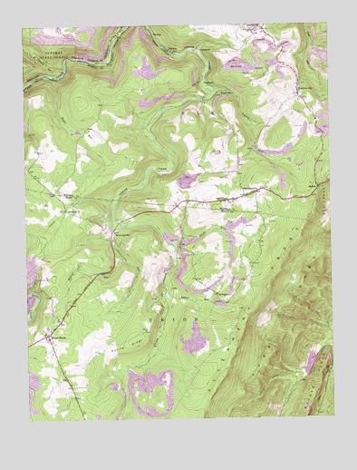
Mount Storm, WV USGS Topographic Map
Click on map above to begin viewing in our Map Viewer.

This topographic map contains these locations and features:
Feature Name Type Latitude Longitude GNIS ID View Map
Allegheny Mining HeliportAirportN39.3193°W79.1717°1558799View Map
Blackburn CemeteryCemeteryN39.3415°W79.2225°1936841View Map
Blake ChapelChurchN39.3195°W79.1664°1536081View Map
CrosstownPopulated PlaceN39.3562°W79.1767°1554229View Map
Dixon CemeteryCemeteryN39.3426°W79.1348°1538214View Map
Duling RidgeRidgeN39.2740°W79.2081°1538419View Map
Emory CreekStreamN39.3562°W79.1745°1538708View Map
EmoryvillePopulated PlaceN39.3534°W79.1703°1538709View Map
Empire School (historical)SchoolN39.3473°W79.2195°1557040View Map
Evans CemeteryCemeteryN39.3193°W79.1659°1937342View Map
Glade RunStreamN39.3051°W79.1892°1539435View Map
Gleason (historical)Populated PlaceN39.3629°W79.2173°1557043View Map
Grant Memorial Hospital AmbulanceBuildingN39.2771°W79.2418°2581124View Map
HartmansvillePopulated PlaceN39.3220°W79.1550°1540033View Map
Johnnycake RunStreamN39.3143°W79.2142°1540957View Map
Kalbough CemeteryCemeteryN39.3745°W79.1581°1541058View Map
Kitzmiller CemeteryCemeteryN39.3498°W79.1356°1937363View Map
Laurel RunStreamN39.2920°W79.1928°1541519View Map
Lostland RunStreamN39.3618°W79.2323°585609View Map
Maple RunStreamN39.3584°W79.2370°1542735View Map
Mount PisgahPopulated PlaceN39.2898°W79.1714°1549838View Map
Mount Pisgah Church (historical)ChurchN39.2898°W79.1717°1557019View Map
Mount StormPopulated PlaceN39.2773°W79.2409°1543766View Map
Mount Storm Post OfficePost OfficeN39.2778°W79.2404°1697261View Map
Mount Storm Volunteer Fire DepartmentBuildingN39.2771°W79.2418°2577869View Map
Mount Vernon School (historical)SchoolN39.2570°W79.2306°1557020View Map
Murphy CemeteryCemeteryN39.3390°W79.2450°1937381View Map
Nethken School (historical)SchoolN39.3748°W79.1581°1557052View Map
New Creek Structure 14 DamDamN39.2704°W79.1323°1557442View Map
Number 15LocaleN39.3673°W79.1784°1544247View Map
Number 7 HillSummitN39.3626°W79.1620°1555229View Map
OakmontPopulated PlaceN39.3668°W79.1884°1544316View Map
Rehoboth ChurchChurchN39.3165°W79.2325°1545505View Map
Sand SpringSpringN39.3365°W79.1264°1677644View Map
Schaeffer CemeteryCemeteryN39.2609°W79.2309°1546488View Map
Schell School (historical)SchoolN39.3373°W79.2445°1557057View Map
SkylinePopulated PlaceN39.3237°W79.1292°1546877View Map
Sulphur CityPopulated PlaceN39.3532°W79.1375°1547709View Map
Sulphur City ChurchChurchN39.3532°W79.1384°1939810View Map
Terra Firma School (historical)SchoolN39.2940°W79.1803°1557035View Map
The EddyLocaleN39.3723°W79.1970°1548002View Map
Union High SchoolSchoolN39.2779°W79.2420°1697280View Map
Wabash (historical)Populated PlaceN39.3279°W79.1817°1557061View Map
White Hall School (historical)SchoolN39.3095°W79.2136°1549028View Map
Wycroff RunStreamN39.3020°W79.2111°1549442View Map

Note: Coordinates in the location and feature list above are referenced to NAD83 datum.


Copyright (C) 2008-2025 Ryan Niemi / Sunset Dynamics ... All Rights Reserved