TopoQuest Logo
Do you find TopoQuest useful?
Help keep TopoQuest running and adding new maps/features by donating!
Bitcoin:  19c7KJd3qBynnjoSw5npx9KScwjBe4ifkT
Litecoin:  LXs6TkuXGGXo1vDsWCkWVdjQX94eUKd6ui
Home View Maps Find Maps Find Places Resources & Links


Greenland Gap, West Virginia Topographic Map

USGS Map Title: Greenland Gap, WV
USGS Map MRC: 39079B2
DRG (GeoTIFF) Download: o39079b2.tif


Neighboring USGS Topographic Map Quads:


  Gorman, MD  
39079C3
 

  Mount Storm, WV  
39079C2
 

  Antioch, WV  
39079C1
 

  Mount Storm Lake, WV  
39079B3
 

  Greenland Gap, WV  
39079B2
 

  Medley, WV  
39079B1
 

  Blackbird Knob, WV  
39079A3
 

  Maysville, WV  
39079A2
 

  Rig, WV  
39079A1


Map MRC Location:

N40°
W80°
N40°
W79°
H8 H7 H6 H5 H4 H3 H2 H1
G8 G7 G6 G5 G4 G3 G2 G1
F8 F7 F6 F5 F4 F3 F2 F1
E8 E7 E6 E5 E4 E3 E2 E1
D8 D7 D6 D5 D4 D3 D2 D1
C8 C7 C6 C5 C4 C3 C2 C1
B8 B7 B6 B5 B4 B3 B2 B1
A8 A7 A6 A5 A4 A3 A2 A1
N39°
W80°
N39°
W79°

Greenland Gap, WV USGS 1:24K Topographic Map Preview:
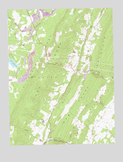
Greenland Gap, WV USGS Topographic Map
Click on map above to begin viewing in our Map Viewer.

This topographic map contains these locations and features:
Feature Name Type Latitude Longitude GNIS ID View Map
Allegheny Church of the BrethrenChurchN39.2126°W79.2256°1697216View Map
Allegheny FrontRidgeN39.2232°W79.1989°1550088View Map
BismarckPopulated PlaceN39.2179°W79.2331°1549596View Map
Brick ChurchChurchN39.1312°W79.2034°1536331View Map
Brick Church SpringSpringN39.1318°W79.2042°1677866View Map
Cold SpringSpringN39.1834°W79.1331°1677865View Map
Cosner GapGapN39.1282°W79.1914°1537693View Map
Elklick RunStreamN39.1929°W79.1689°1538660View Map
Excelsior School (historical)SchoolN39.1487°W79.2023°1557002View Map
Fore KnobsSummitN39.2051°W79.1928°1554484View Map
Forest Hill School (historical)SchoolN39.1607°W79.1864°1557005View Map
Grassy Ridge School (historical)SchoolN39.1765°W79.2423°1557008View Map
GreenlandPopulated PlaceN39.1921°W79.1531°1549717View Map
Greenland GapGapN39.1840°W79.1261°1539711View Map
Laurel RunStreamN39.1976°W79.2381°1541515View Map
Little CreekStreamN39.2282°W79.2200°1542066View Map
Little Creek School (historical)SchoolN39.2184°W79.2189°1557017View Map
Locust Grove ChurchChurchN39.2279°W79.2420°1542295View Map
Lunice Creek Structure Number 10 DamDamN39.1284°W79.2131°1557444View Map
Lunice Creek Structure Number 11 DamDamN39.1451°W79.2081°1557445View Map
Mount Storm HeliportAirportN39.2315°W79.2186°1558824View Map
Mount Storm Power Station DamDamN39.2001°W79.2498°1557440View Map
New Creek MountainRidgeN39.2282°W79.1286°1552293View Map
Oak HillPopulated PlaceN39.1368°W79.1523°1549857View Map
Oak Hill School (historical)SchoolN39.1368°W79.1523°1557024View Map
Oakdale ChurchChurchN39.2329°W79.1520°1544306View Map
Oakdale School (historical)SchoolN39.2287°W79.1550°1557025View Map
Patterson Creek Structure Number Six DamDamN39.2101°W79.1698°1557450View Map
Pigeon Roost Lookout TowerLocaleN39.1873°W79.2236°1697267View Map
PigeonroostSummitN39.1873°W79.2239°1544819View Map
Saltblock RunStreamN39.1262°W79.2089°1546310View Map
ScherrPopulated PlaceN39.1932°W79.1700°1549915View Map
Scherr Post OfficePost OfficeN39.1926°W79.1695°1697271View Map
Shell RunStreamN39.1254°W79.1806°1546662View Map
Walker RidgeRidgeN39.1976°W79.1584°1548729View Map

Note: Coordinates in the location and feature list above are referenced to NAD83 datum.


Copyright (C) 2008-2025 Ryan Niemi / Sunset Dynamics ... All Rights Reserved