TopoQuest Logo
Do you find TopoQuest useful?
Help keep TopoQuest running and adding new maps/features by donating!
Bitcoin:  19c7KJd3qBynnjoSw5npx9KScwjBe4ifkT
Litecoin:  LXs6TkuXGGXo1vDsWCkWVdjQX94eUKd6ui
Home View Maps Find Maps Find Places Resources & Links


Keatchie, Louisiana Topographic Map

USGS Map Title: Keatchie, LA
USGS Map MRC: 32093B8
DRG (GeoTIFF) Download: o32093b8.tif


Neighboring USGS Topographic Map Quads:


  Panola, LA  
32094C1
 

  Spring Ridge, LA  
32093C8
 

  Stonewall, LA  
32093C7
 

  Old Panola, TX  
32094B1
 

  Keatchie, LA  
32093B8
 

  Gloster, LA  
32093B7
 

  Galloway, TX  
32094A1
 

  Longstreet, LA  
32093A8
 

  Grand Cane, LA  
32093A7


Map MRC Location:

N33°
W94°
N33°
W93°
H8 H7 H6 H5 H4 H3 H2 H1
G8 G7 G6 G5 G4 G3 G2 G1
F8 F7 F6 F5 F4 F3 F2 F1
E8 E7 E6 E5 E4 E3 E2 E1
D8 D7 D6 D5 D4 D3 D2 D1
C8 C7 C6 C5 C4 C3 C2 C1
B8 B7 B6 B5 B4 B3 B2 B1
A8 A7 A6 A5 A4 A3 A2 A1
N32°
W94°
N32°
W93°

Keatchie, LA USGS 1:24K Topographic Map Preview:
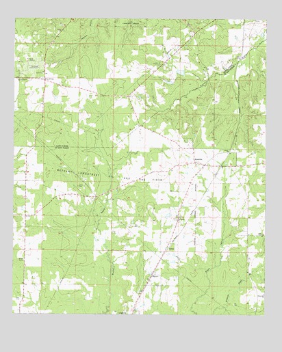
Keatchie, LA USGS Topographic Map
Click on map above to begin viewing in our Map Viewer.

This topographic map contains these locations and features:
Feature Name Type Latitude Longitude GNIS ID View Map
Bethany Longstreet Oil and Gas FieldOilfieldN32.1821°W93.9527°532969View Map
Burris School (historical)SchoolN32.2440°W93.9782°541228View Map
Caddo Correctional InstituteLocaleN32.2493°W93.9424°533605View Map
Charity ChurchChurchN32.1940°W93.8935°533880View Map
Flower Hill Baptist ChurchChurchN32.1338°W93.8755°554442View Map
Flower Hill CemeteryCemeteryN32.1346°W93.8757°535013View Map
Four ForksPopulated PlaceN32.2238°W93.9849°543218View Map
Four Forks Lookout TowerTowerN32.2299°W93.9885°558772View Map
Fullalove CemeteryCemeteryN32.2321°W93.9905°535139View Map
Gatlin CemeteryCemeteryN32.1793°W93.9680°535193View Map
Good Hope ChurchChurchN32.1885°W93.9185°541226View Map
Holiness ChurchChurchN32.1416°W93.9305°535715View Map
Joseph Grove School (historical)SchoolN32.2357°W93.9096°541227View Map
KeatchiePopulated PlaceN32.1885°W93.9055°554912View Map
KolterPopulated PlaceN32.1529°W93.9244°543365View Map
Liberty ChurchChurchN32.2443°W93.9780°536422View Map
Little Rock School (historical)SchoolN32.2107°W93.9855°541222View Map
Maeora Airport (historical)AirportN32.2393°W93.9219°1632939View Map
Mary Evergreen ChurchChurchN32.2243°W93.9982°536925View Map
Milton Crowe Lake Number One DamDamN32.2285°W93.9219°556998View Map
Milton Crowe Lake Number Two DamDamN32.2235°W93.9269°556999View Map
Parish Governing Authority District 1ACivilN32.1440°W93.9318°1929862View Map
Shiloh CampLocaleN32.1482°W93.9946°539335View Map
Spring Hill ChurchChurchN32.1652°W93.9188°539597View Map
Town of KeachiCivilN32.1708°W93.9160°2405931View Map
Ward OneCivilN32.1341°W93.9355°544995View Map
Whitley (historical)Populated PlaceN32.1668°W93.9941°545672View Map

Note: Coordinates in the location and feature list above are referenced to NAD83 datum.


Copyright (C) 2008-2025 Ryan Niemi / Sunset Dynamics ... All Rights Reserved