TopoQuest Logo
Do you find TopoQuest useful?
Help keep TopoQuest running and adding new maps/features by donating!
Bitcoin:  19c7KJd3qBynnjoSw5npx9KScwjBe4ifkT
Litecoin:  LXs6TkuXGGXo1vDsWCkWVdjQX94eUKd6ui
Home View Maps Find Maps Find Places Resources & Links


Grandin, North Carolina Topographic Map

USGS Map Title: Grandin, NC
USGS Map MRC: 36081A4
DRG (GeoTIFF) Download: o36081a4.tif


Neighboring USGS Topographic Map Quads:


  Deep Gap, NC  
36081B5
 

  Maple Springs, NC  
36081B4
 

  Purlear, NC  
36081B3
 

  Buffalo Cove, NC  
36081A5
 

  Grandin, NC  
36081A4
 

  Boomer, NC  
36081A3
 

  Lenoir, NC  
35081H5
 

  Kings Creek, NC  
35081H4
 

  Ellendale, NC  
35081H3


Map MRC Location:

N37°
W82°
N37°
W81°
H8 H7 H6 H5 H4 H3 H2 H1
G8 G7 G6 G5 G4 G3 G2 G1
F8 F7 F6 F5 F4 F3 F2 F1
E8 E7 E6 E5 E4 E3 E2 E1
D8 D7 D6 D5 D4 D3 D2 D1
C8 C7 C6 C5 C4 C3 C2 C1
B8 B7 B6 B5 B4 B3 B2 B1
A8 A7 A6 A5 A4 A3 A2 A1
N36°
W82°
N36°
W81°

Grandin, NC USGS 1:24K Topographic Map Preview:
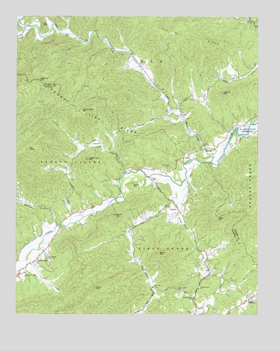
Grandin, NC USGS Topographic Map
Click on map above to begin viewing in our Map Viewer.

This topographic map contains these locations and features:
Feature Name Type Latitude Longitude GNIS ID View Map
Blue CreekStreamN36.0012°W81.4018°981623View Map
Browns MountainSummitN36.0646°W81.3837°1805953View Map
Butte MountainSummitN36.0257°W81.4262°982338View Map
Chestnut MountainSummitN36.0985°W81.4890°1019652View Map
Cilley (historical)Populated PlaceN36.0426°W81.4701°1001501View Map
County Line RidgeRidgeN36.0854°W81.4679°983611View Map
DarbyPopulated PlaceN36.1212°W81.4954°1006171View Map
Denny (historical)Populated PlaceN36.0918°W81.4226°1805954View Map
Denny Station (historical)LocaleN36.1043°W81.4359°1805955View Map
Dugger CreekStreamN36.1190°W81.4940°1020043View Map
Elk ChurchChurchN36.0840°W81.4134°984694View Map
Elk CreekStreamN36.0643°W81.3990°984697View Map
ElkvillePopulated PlaceN36.0699°W81.4018°984718View Map
Fort DefiancePopulated PlaceN36.0171°W81.4951°1020328View Map
German ChapelChurchN36.0454°W81.4226°985639View Map
Gill KnobSummitN36.0693°W81.4934°985692View Map
GrandinPopulated PlaceN36.0440°W81.4159°1020487View Map
Grandin Baptist ChurchChurchN36.0429°W81.4159°1001511View Map
Hawkins CreekStreamN36.0371°W81.4787°1011919View Map
Jerry MountainSummitN36.0410°W81.3956°987579View Map
Kings CreekStreamN36.0562°W81.4129°987998View Map
Laurel Hills Church (historical)ChurchN36.0990°W81.3920°1805956View Map
Laytown CreekStreamN36.0593°W81.4429°1012760View Map
Lenoir (historical)Populated PlaceN36.0354°W81.4782°1001516View Map
Little Kings CreekStreamN36.0396°W81.4162°988691View Map
Little MountainSummitN36.0540°W81.4398°1021217View Map
Livingston Memorial ChurchChurchN36.0065°W81.3779°988823View Map
Maria ChapelChurchN36.0574°W81.4298°989334View Map
Mill CreekStreamN36.0196°W81.4962°989928View Map
Mount Bethel CemeteryCemeteryN36.0107°W81.4159°990315View Map
Mount Bethel ChurchChurchN36.0074°W81.4087°990320View Map
New Hope ChurchChurchN36.0121°W81.4281°991015View Map
Patterson Grove ChurchChurchN36.0112°W81.4045°991941View Map
Piney Grove ChurchChurchN36.0240°W81.4834°992360View Map
Rock Island Church (historical)ChurchN36.1107°W81.4473°1805957View Map
Round TopSummitN36.0418°W81.4487°993754View Map
Sherrill Hill CemeteryCemeteryN36.0626°W81.4206°994670View Map
Sly MountainSummitN36.1218°W81.4862°1022669View Map
Township of ElkCivilN36.1244°W81.4355°1027326View Map
Township of Kings CreekCivilN36.0098°W81.4122°1026485View Map
Tugman MountainSummitN36.0929°W81.3929°996303View Map
Turkey Hen MountainSummitN36.0654°W81.4626°996335View Map
Warrior MountainsRangeN36.0126°W81.4376°1001522View Map
Wheat Patch MountainSummitN36.0840°W81.4645°997102View Map
White MountainSummitN36.0110°W81.4587°997151View Map
Yadkin ValleyPopulated PlaceN36.0224°W81.4901°1016852View Map
Yadkin Valley Volunteer Fire DepartmentBuildingN36.0281°W81.4830°2638118View Map
Yates CreekStreamN36.1215°W81.3762°997693View Map

Note: Coordinates in the location and feature list above are referenced to NAD83 datum.


Copyright (C) 2008-2025 Ryan Niemi / Sunset Dynamics ... All Rights Reserved